HISTORIX Vintage 1874 South Bend Indiana Map and 50 similar items


Free Shipping
HISTORIX Vintage 1874 South Bend Indiana Map - 18x24 Inch Old South Bend St Jose
$39.99 - $54.99
View full item details »

Shipping options
Seller handling time is 1 business day Details
FREE via to United States
Return policy
Full refund available for DOAs
Details
Purchase protection
Payment options
PayPal accepted
PayPal Credit accepted
Venmo accepted
PayPal, MasterCard, Visa, Discover, and American Express accepted
Maestro accepted
Amazon Pay accepted
Nuvei accepted
View full item details »
Shipping options
Seller handling time is 1 business day Details
FREE via to United States
Return policy
Full refund available for DOAs
Details
Purchase protection
Payment options
PayPal accepted
PayPal Credit accepted
Venmo accepted
PayPal, MasterCard, Visa, Discover, and American Express accepted
Maestro accepted
Amazon Pay accepted
Nuvei accepted
Item traits
| Category: | |
|---|---|
| Quantity Available: |
16 in stock |
| Condition: |
New |
| ASIN: |
B09VD7P5XL |
| Item Name: |
1874 South Bend Indiana Poster Print |
| Item Type Keyword: |
prints |
| sizes: |
Listing details
| Seller policies: | |
|---|---|
| Shipping discount: |
Seller pays shipping for this item. |
| Posted for sale: |
April 21 |
| Item number: |
1741421615 |
Item description
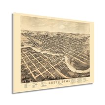
Produced, published, and illustrated by two of the most prolific American cartographers of the period, this stunning depiction of South Bend, Indiana, shows the city in a period of significant growth and transformation after being officially incorporated in 1865. The arrival of the first railroad in 1851 allowed the city to grow and expand as a cultural and economic center for the entire region. Its location on the banks of the St. Joseph River allowed a thriving industrial economy to begin and spurred on prosperity throughout the latter portions of the nineteenth century. Large numbers of immigrants settled in the area, with many communities of Europeans creating neighborhoods based along cultural lines, many of which exist to this day. The iconic University of Notre Dame was founded just north of the city and remains an enduring part of the area’s distinctive culture.
Birds eye perspectives were created to attract residents and merchants alike and served to promote civic features, religious and educational institutions, as well as other economic opportunities. Panoramic maps were widely popular during the latter portions of the nineteenth century until the 1920s, when technological advances in aviation made aerial photography a possibility. These maps bear a unique aesthetic that is immediately recognizable and transports the viewer back in time, creating an indelible bond between the past and present.
This is an authentic piece of American cartographical history that captures the significant transformation occurring across the nation in the years following the conclusion of the American Civil War.
Our museum quality giclee print comes printed with archival ink on premium heavyweight matte paper. Shipped in a sturdy cardboard tube your print will arrive ready to be framed. This eye-catching vintage map reproduction print makes the perfect gift for anyone that loves history and imagery.
|
Why are we showing these items?
Booth
Historic Prints |

|


-
Refine your browsing experience
We can show you more items that are exactly like the original item, or we can show you items that are similar in spirit. By default we show you a mix.


This item has been added to your cart
 HISTORIX Vintage 1874 South Bend Indiana Map - 18x24 Inch Old South Bend St Jose added to cart.
16 available in stock
HISTORIX Vintage 1874 South Bend Indiana Map - 18x24 Inch Old South Bend St Jose added to cart.
16 available in stock
View Cart or continue shopping.
 Please wait while we finish adding this item to your cart.
Get an item reminder
We'll email you a link to your item now and follow up with a single reminder (if you'd like one). That's it! No spam, no hassle.
Already have an account?
Log in and add this item to your wish list.