HISTORIX Vintage 1883 Superior Wisconsin Map and similar items


Free Shipping
HISTORIX Vintage 1883 Superior Wisconsin Map - 12x24 Inch Vintage Superior Map o
$37.99 - $59.99
View full item details »

Shipping options
Seller handling time is 1 business day Details
FREE via to United States
Return policy
Full refund available for DOAs
Details
Purchase protection
Payment options
PayPal accepted
PayPal Credit accepted
Venmo accepted
PayPal, MasterCard, Visa, Discover, and American Express accepted
Maestro accepted
Amazon Pay accepted
Nuvei accepted
View full item details »
Shipping options
Seller handling time is 1 business day Details
FREE via to United States
Return policy
Full refund available for DOAs
Details
Purchase protection
Payment options
PayPal accepted
PayPal Credit accepted
Venmo accepted
PayPal, MasterCard, Visa, Discover, and American Express accepted
Maestro accepted
Amazon Pay accepted
Nuvei accepted
Item traits
| Category: | |
|---|---|
| Quantity Available: |
16 in stock |
| Condition: |
New |
| ASIN: |
B09RQNKMKW |
| Item Name: |
1883 Superior, Wisconsin Poster Print |
| Item Type Keyword: |
prints |
| sizes: |
Listing details
| Seller policies: | |
|---|---|
| Shipping discount: |
Seller pays shipping for this item. |
| Posted for sale: |
April 21 |
| Item number: |
1741421580 |
Item description
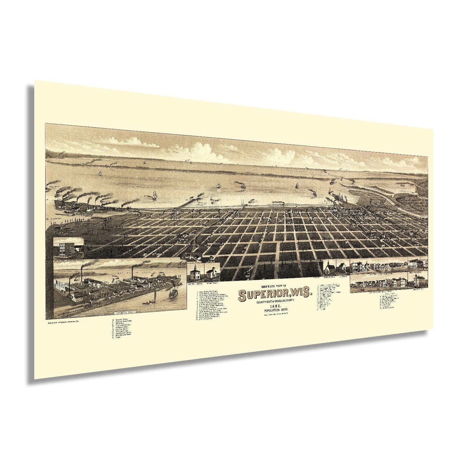
Produced and published by one of the most prolific American mapmakers of the era, Henry Wellge, one of six cartographers who were responsible for the creation of more than half of all birds eye perspective of cities across the United States. The style bears a distinctive aesthetic that immediately transports the viewer back in time. They were widely popular during the mid-nineteenth and early twentieth centuries and served as marketing materials to attract residents and merchants alike. They often featured prominent civic features and economic opportunities as well as other notable buildings and schools.
The Seat of Douglas County, Superior, Wisconsin, is framed by the Nemadji and Saint Louis Rivers across the bay from Duluth, which forms the so-called Twin Ports. The two cities shared harbor is one of the most important ports on the Great Lakes. This map was published before the Boom Period, which began in 1888, and shows the town on the brink of significant transformation and population growth. Between 1890 and 1920, the region was heavily settled by immigrants coming from Eastern and Western Europe, England, Scandinavia, and Germany. These communities founded numerous neighborhoods based on cultural lines, many of which remain to this day.
Wellge’s depiction of the city captures a unique moment in the city’s rich history that illustrates the importance of the geographic proximity to the waters of Lake Superior. This is an authentic piece of American cartographical history that illustrates the early signs of its importance as an industrial center.
Our museum quality giclee print comes printed with archival ink on premium heavyweight matte paper. Shipped in a sturdy cardboard tube your print will arrive ready to be framed. This eye-catching vintage map reproduction print makes the perfect gift for anyone that loves history and imagery.
Loading
This item has been added to your cart
 HISTORIX Vintage 1883 Superior Wisconsin Map - 12x24 Inch Vintage Superior Map o added to cart.
16 available in stock
HISTORIX Vintage 1883 Superior Wisconsin Map - 12x24 Inch Vintage Superior Map o added to cart.
16 available in stock
View Cart or continue shopping.
 Please wait while we finish adding this item to your cart.
Get an item reminder
We'll email you a link to your item now and follow up with a single reminder (if you'd like one). That's it! No spam, no hassle.
Already have an account?
Log in and add this item to your wish list.