HISTORIX Vintage 1725 Africa Map - 18x24 and similar items


Free Shipping
HISTORIX Vintage 1725 Africa Map - 18x24 Inch Vintage Map Poster - Africa Wall A
$39.99 - $59.99
View full item details »

Shipping options
Seller handling time is 1 business day Details
FREE via to United States
Return policy
Full refund available for DOAs
Details
Purchase protection
Payment options
PayPal accepted
PayPal Credit accepted
Venmo accepted
PayPal, MasterCard, Visa, Discover, and American Express accepted
Maestro accepted
Amazon Pay accepted
Nuvei accepted
View full item details »
Shipping options
Seller handling time is 1 business day Details
FREE via to United States
Return policy
Full refund available for DOAs
Details
Purchase protection
Payment options
PayPal accepted
PayPal Credit accepted
Venmo accepted
PayPal, MasterCard, Visa, Discover, and American Express accepted
Maestro accepted
Amazon Pay accepted
Nuvei accepted
Item traits
| Category: | |
|---|---|
| Quantity Available: |
16 in stock |
| Condition: |
New |
| ASIN: |
B08MFQKNHX |
| Item Name: |
HISTORIX 1725 Africa |
| manufacturer: |
HISTORIX |
| Item Type Keyword: |
prints |
| Brand: |
HISTORIX |
| Unspsc Code: |
52140000 |
| sizes: |
Listing details
| Seller policies: | |
|---|---|
| Shipping discount: |
Seller pays shipping for this item. |
| Posted for sale: |
April 21 |
| Item number: |
1741421655 |
Item description
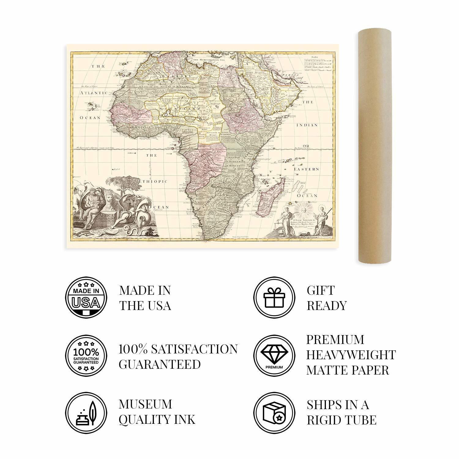
Created by one of the most prominent and prolific cartographers of the eighteenth century, John Senex, this stunning depiction of Africa in 1725 bears a striking detail and unique aesthetic that immediately transports the viewer back in time, creating a link between the past and the present. Senex was the official geographer to Queen Anne of Britain and created the world's first pocket-sized map. As one of the eighteenth-century principal cartographers, his remarkable accuracy and detail set this map apart from other works of the time. Senex was elected into the Royal Society of London in 1728.
European explorers had come to Africa as early as the fifteenth century, and by 1725 colonizers from Europe were arriving and establishing boundaries that would define the continent's geopolitics for the next two centuries. Senex's work served as one of the most detailed and accurate maps, which became invaluable tools for British expeditions during this time. Trading posts had long been established in Africa's coastal regions, and these markets bustled with European traders from the North, Chinese merchants from the East, and Arabian traders.
One interesting feature of this map is that it defines nearly every region, which depictions even into the 1800s often left unlabeled. Exploration and colonization of Africa would occur for the bulk of the eighteenth and nineteenth centuries. This rare production is truly an authentic piece of cartographical history. It stands as a distinctive artifact of the rich history of both Africa and Britain.
Our museum quality giclee print comes printed with archival ink on premium heavyweight matte paper. Shipped in a sturdy cardboard tube your print will arrive ready to be framed. This eye-catching vintage map reproduction print makes the perfect gift for anyone that loves history and imagery.
Loading
This item has been added to your cart
 HISTORIX Vintage 1725 Africa Map - 18x24 Inch Vintage Map Poster - Africa Wall A added to cart.
16 available in stock
HISTORIX Vintage 1725 Africa Map - 18x24 Inch Vintage Map Poster - Africa Wall A added to cart.
16 available in stock
View Cart or continue shopping.
 Please wait while we finish adding this item to your cart.
Get an item reminder
We'll email you a link to your item now and follow up with a single reminder (if you'd like one). That's it! No spam, no hassle.
Already have an account?
Log in and add this item to your wish list.