HISTORIX Vintage 1861 American Civil War Map and 50 similar items


Free Shipping
HISTORIX Vintage 1861 American Civil War Map - 18x24 Inch Vintage Map of the Uni
$39.99 - $57.99
View full item details »

Shipping options
Seller handling time is 1 business day Details
FREE via to United States
Return policy
Full refund available for DOAs
Details
Purchase protection
Payment options
PayPal accepted
PayPal Credit accepted
Venmo accepted
PayPal, MasterCard, Visa, Discover, and American Express accepted
Maestro accepted
Amazon Pay accepted
Nuvei accepted
View full item details »
Shipping options
Seller handling time is 1 business day Details
FREE via to United States
Return policy
Full refund available for DOAs
Details
Purchase protection
Payment options
PayPal accepted
PayPal Credit accepted
Venmo accepted
PayPal, MasterCard, Visa, Discover, and American Express accepted
Maestro accepted
Amazon Pay accepted
Nuvei accepted
Item traits
| Category: | |
|---|---|
| Quantity Available: |
16 in stock |
| Condition: |
New |
| ASIN: |
B086WLGNCD |
| Item Name: |
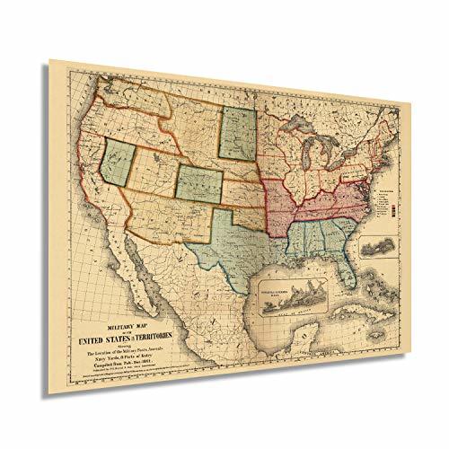
HISTORIX 1861 Military map of the United States & territories |
| manufacturer: |
Historix |
| Item Type Keyword: |
prints |
| Brand: |
HISTORIX |
| Unspsc Code: |
52140000 |
| sizes: |
Listing details
| Seller policies: | |
|---|---|
| Shipping discount: |
Seller pays shipping for this item. |
| Posted for sale: |
April 15 |
| Item number: |
1739668779 |
Item description
This military map produced at the beginning of the Civil War illustrates strategic ports and military installations. Illustrated and published by prominent lithographer and mapmaker Peter Duval, this map is a compilation of public data and allowed military leaders to prepare a strategy for the conflict that would reshape American history forever.
The secession of the southern states in 1861 marked a turning point in an already tense time, and the Union military had readied itself to combat the insurgent South. The loose organization of the Confederate States had called on men from across the South to bear arms and prepare for the inevitable invasion by Union forces.
Shortly after Lincoln’s election, secessionist forces attacked Fort Sumter in South Carolina, and the war officially broke out in April of 1861. The US Navy at the beginning of the war was enlarged to six thousand officers and forty-five thousand enlisted men and became a crucial part of the Union’s success. By establishing and maintaining blockades, the Union gained a valuable upper hand on the ports that were essential for the Southern states, critically establishing a Union presence at the mouth of the Mississippi River.
The Civil War allowed for the development of what would become the modern US Navy and the construction of well-armored ironclad warships as the war had broken out at the beginning of the industrial revolution. The distinct aesthetic and wealth of information provided by this map offer the viewer a glimpse into the past, and it is an authentic piece of cartographical history.
Our museum quality giclee print comes printed with archival ink on premium heavyweight matte paper. Shipped in a sturdy cardboard tube your print will arrive ready to be framed. This eye-catching vintage map print makes the perfect gift for anyone that loves history and imagery.
|
Why are we showing these items?
Booth
Historic Prints |

|


-
Refine your browsing experience
We can show you more items that are exactly like the original item, or we can show you items that are similar in spirit. By default we show you a mix.


This item has been added to your cart
 HISTORIX Vintage 1861 American Civil War Map - 18x24 Inch Vintage Map of the Uni added to cart.
16 available in stock
HISTORIX Vintage 1861 American Civil War Map - 18x24 Inch Vintage Map of the Uni added to cart.
16 available in stock
View Cart or continue shopping.
 Please wait while we finish adding this item to your cart.
Get an item reminder
We'll email you a link to your item now and follow up with a single reminder (if you'd like one). That's it! No spam, no hassle.
Already have an account?
Log in and add this item to your wish list.