Rendered at 06:46:16 08/07/25


United Kingdom & Ireland, map Senex, 1728, A Globular Chart Shewing the errors..
$279.00
Ships from
Spain

Shipping options
Estimated to arrive by Wed, Aug 13th.
Details
$30.00 via Standard shipping (1 to 5 business days) to United States
Ships from
Spain
Offer policy
OBO - Seller accepts offers on this item.
Details
Return policy
Full refund available within 30 days
Purchase protection
Payment options
PayPal accepted
PayPal Credit accepted
Venmo accepted
PayPal, MasterCard, Visa, Discover, and American Express accepted
Maestro accepted
Amazon Pay accepted
Nuvei accepted
Item traits
| Category: | |
|---|---|
| Quantity Available: |
Only one in stock, order soon |
| Condition: |
Unspecified by seller, may be new. |
| Type: |
Nautical Map |
| Original/Reproduction: |
Antique Original |
| Date Range: |
1700-1799 |
| Year: |
1728 |
| Country/Region: |
England |
| City: |
London |
| Cartographer/Publisher: |
John Senex |
| Format: |
Atlas Map |
| Printing Technique: |
Copper Plate |
Listing details
| Seller policies: | |
|---|---|
| Shipping discount: |
No combined shipping offered |
| Posted for sale: |
More than a week ago |
| Item number: |
1756410596 |
Item description
Old
maps, Genuine antiques
No
copies
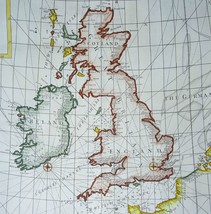
United
Kingdom Ireland
Senex,
1728,
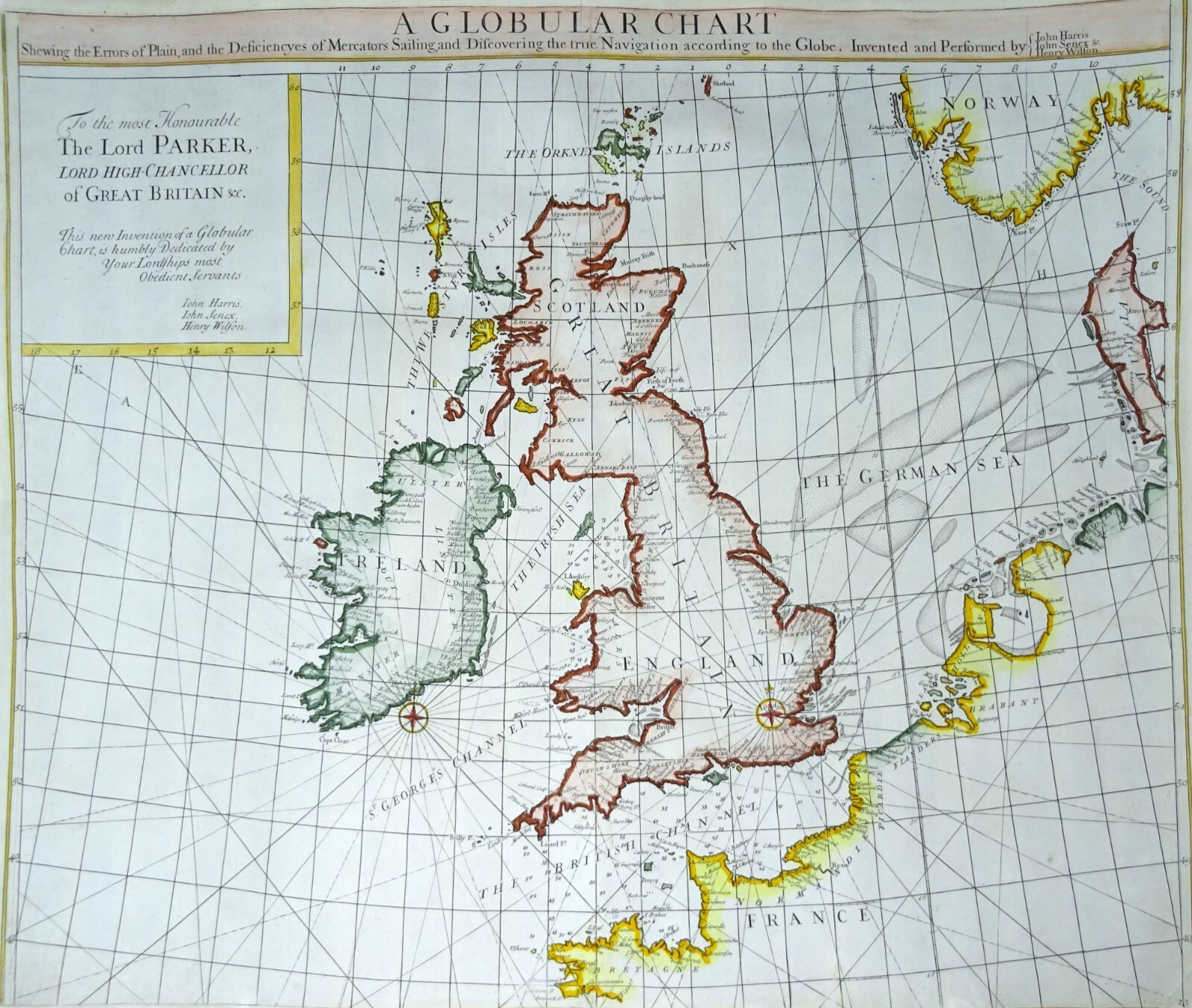
A Globular Chart Shewing the errors of Plain, and the Deficiencyes of
Mercators Sailing, and Discovering the true Navigation according to
the Globe...
Cartographer
/ Cartografo
Senex
/ Wilson
Title
/ Título
A
Globular Chart Shewing the errors of Plain, and the Deficiencyes
of Mercators Sailing, and Discovering the true Navigation
according to the Globe. Invented and perdorde by John Harris John
Senex Henry Wilson.
Year
/ Año
1728
Size
/ Tamaño
18th
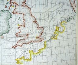
century copper engraved antique nautical chart by Senex showing
the British Isles. It is the top half of a map showing Western
Europe.
It
shows an alternate projection of the globe as a flat map to the
prevailing Mercator Projection. Includes rhumb lines and coastal
details. From Atlas Maritimus, a commercial sea atlas was
published as a guide to British global commerce. Good condition
with some stains along lower center fold. Sir Edmond Halley
(1656--1742) was an English astronomer, geophysicist,
mathematician, meteorologist, and physicist known for computing
the orbit of the eponymous Halley's Comet. He was the second
Astronomer Royal in Britain after John Flamsteed. John Senex (1678
to1740) was an English cartographer, engraver and explorer who
worked prominently in the 18th century. He is especially known for
his maps of the world, some of which have added elevations and
minuscule detailed engravings. Globular Projection maps were
invented by Halley, Harris and Senex.
McLaughlin,
no.207; Shirley (BL Atlases) no.M.HALL-1a; Wagner, ?Northwest?,
no.532. KAP
Published
in London by James Knapton, 1728.This chart was included in an
important English maritime atlas of the early-eighteenth century,
the Atlas Maritimus et Commercialis.
Description
/ Descripcion
Image
51x62cm, page 54,5x64cm
Condition
/ Estado
Very
good condition.
Reference
number
Ref.
25
1 C
Remarks
/ Comentarios
Please
read the part about the condition of the map and study the
pictures carefully before buying. I sell original maps, often
several centuries old, and they therefore will have signs of
age and use.
Por
favor, estudie atentamente las fotos y el texto para conocer el
estado del mapa antes de adquirirlo. Se trata de un mapa original
que tiene unos siglos de antigüedad, razon por la que presenta
ciertas marcas de uso.
Payment
and shipment / Pago y envío
Payment
/ Pago
With
bank transfer to Spanish or Dutch bank account or with PayPal (the
seller prefers a bank transfer).
Pago
por transferencia bancaria a cuenta española u holandesa o con
PayPal (el vendedor prefiere transferencia).
Shipment
/ Envío
In
case you choose to have the item shipped without certified/insured
mail, the seller will not be responsible for safe arrival of the
shipment. If
needed, a proof of shipment can be provided.
En
caso de que usted no elija correo certificado, el vendedor no se
hara responsable si su paquete no llega bien. Si
lo desea, recibira un comprobante de envío.
Return
policy / devolucion
In
case you do not like the map, you can return it to the seller
within 10 days after receiving it. You are responsible for the
costs for return shipment/insurance. You will receive a full
refund of the purchase amount (excl. shipping costs) after the
seller has the map.
En
caso de que al final no le guste el mapa, puede devolverlo en un
plazo de 10 días tras recibirlo. Los gastos de envío
(certificado) corren de su cargo. Cuando el vendedor reciba el
mapa, le sera devuelto el importe completo de la compra
(excluidos los gastos de envío).
SHIPMENT
CAN BE COMBINED
PUEDEN
MANDARSE VARIOS MAPAS EN UN SOLO ENVÍO
SEE
THE OTHER MAPS I HAVE FOR SALE
MIRE
LOS DEMAS MAPAS QUE TENGO EN VENTA
Keywords:
Added to your wish list!
- United Kingdom & Ireland, map Senex, 1728, A Globular Chart Shewing the errors..
- 1 in stock
- Price negotiable
- Handling time 1 day. Estimated delivery: Wed, Aug 13th
- Returns/refunds accepted
Get an item reminder
We'll email you a link to your item now and follow up with a single reminder (if you'd like one). That's it! No spam, no hassle.
Already have an account?
Log in and add this item to your wish list.