Rendered at 16:15:51 05/31/25
Free Shipping
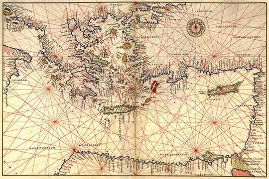
Portolan or Navigational Map of Greece, the Mediterranean and the Levant 20 x 30
$25.98

Shipping options
Estimated to arrive by Tue, Jun 10th.
Details
FREE via Standard shipping (1 to 5 business days) to United States
Return policy
Purchase protection
Payment options
PayPal accepted
PayPal Credit accepted
Venmo accepted
PayPal, MasterCard, Visa, Discover, and American Express accepted
Maestro accepted
Amazon Pay accepted
Nuvei accepted
Item traits
| Category: | |
|---|---|
| Quantity Available: |
7 in stock |
| Condition: |
New with tags |
Listing details
| Shipping discount: |
Seller pays shipping for this item. |
|---|---|
| Posted for sale: |
More than a week ago |
| Item number: |
1046215259 |
Item description
20inch x 30inch Poster Portolan or Navigational Map of Greece, the Mediterranean and the Levant. Done in 1544 by the Italian cartographer Battista Agnese. Battista Agnese (c. 1500 ?? 1564) was a cartographer from the Republic of Genoa, who worked in the Venetian Republic. - There is a border around the image. Image size is correct.
Added to your wish list!
- Portolan or Navigational Map of Greece, the Mediterranean and the Levant 20 x 30
- 7 in stock
- Handling time 4 days. Estimated delivery: Tue, Jun 10th
Get an item reminder
We'll email you a link to your item now and follow up with a single reminder (if you'd like one). That's it! No spam, no hassle.
Already have an account?
Log in and add this item to your wish list.