Rendered at 07:32:31 08/07/25


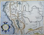
Peru, Ecuador, Bolivia – Rare! Cornelius van Wytfliet, 1597, Peruani Regni..
$419.00
Ships from
Spain

Shipping options
Estimated to arrive by Wed, Aug 13th.
Details
$15.00 via Standard shipping (1 to 5 business days) to United States
Ships from
Spain
Offer policy
OBO - Seller accepts offers on this item.
Details
Return policy
Full refund available within 30 days
Purchase protection
Payment options
PayPal accepted
PayPal Credit accepted
Venmo accepted
PayPal, MasterCard, Visa, Discover, and American Express accepted
Maestro accepted
Amazon Pay accepted
Nuvei accepted
Item traits
| Category: | |
|---|---|
| Quantity Available: |
Only one in stock, order soon |
| Condition: |
Unspecified by seller, may be new. |
| Type: |
Topographical Map |
| Original/Reproduction: |
Antique Original |
| Date Range: |
1500-1599 |
| Year: |
1597 |
| Country/Region: |
Bolivia |
| City: |
Lima |
| Format: |
Atlas Map |
| Printing Technique: |
Copper Plate |
| Cartographer/Publisher: |
Cornelius van Wytfliet |
Listing details
| Seller policies: | |
|---|---|
| Shipping discount: |
No combined shipping offered |
| Posted for sale: |
More than a week ago |
| Item number: |
1755527510 |
Item description
Old
maps, Genuine antiques
No
copies
Peru,
Ecuador, Bolivia ? Rare!
Cornelius
van Wytfliet, 1597,
Peruani Regni Descriptio 1597
Cartographer
/ Cartografo
Cornelius
van Wytfliet
Title
/ Título
Peruani
Regni Descriptio 1597
Year
/ Año
1597
Size
/ Tamaño
Image
23x29cm, page 28x38cm
Description
/ Descripcion
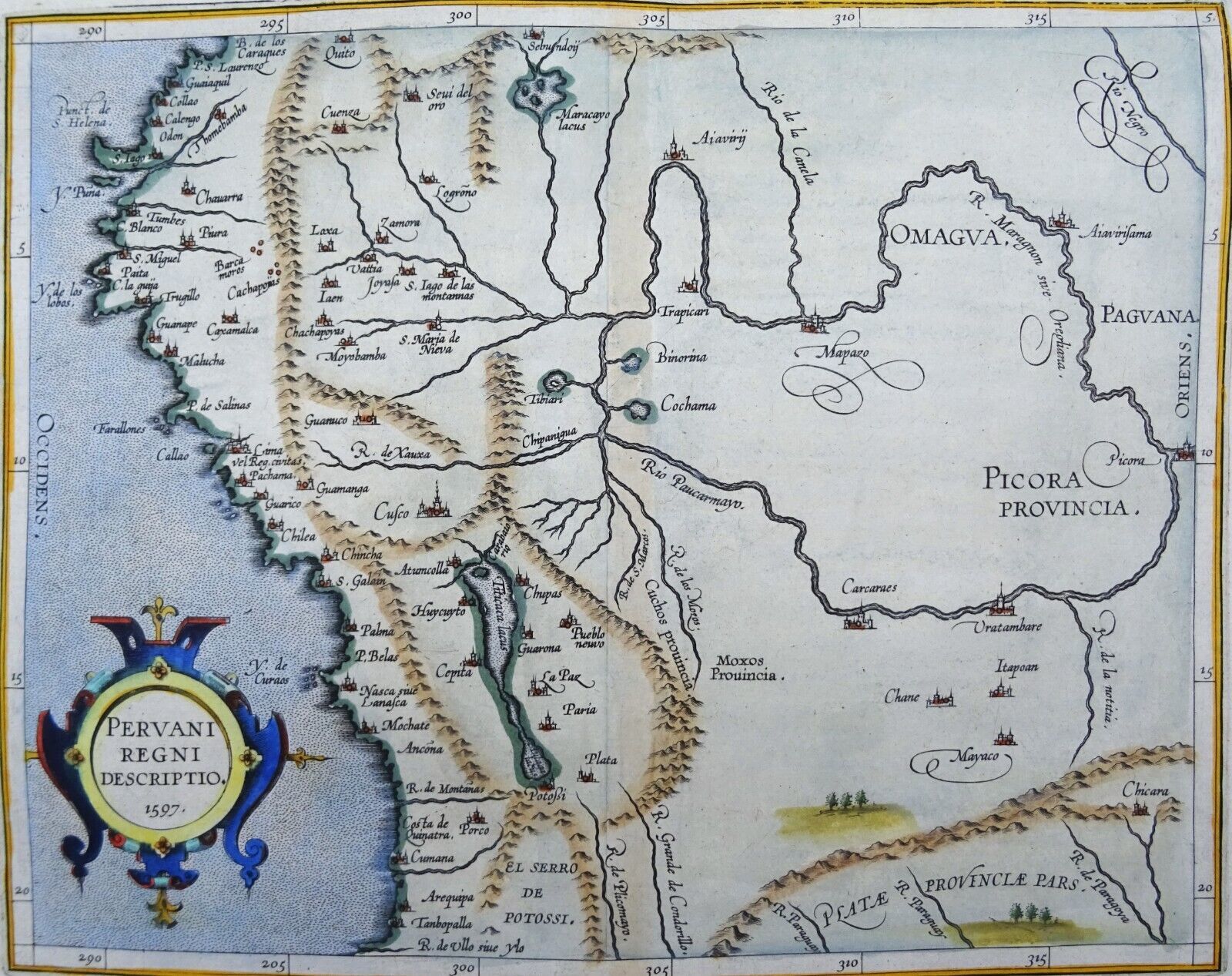
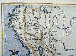
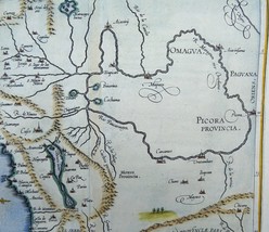
Late
16th century copper engraved antique map of Peru that also
includes parts of Bolivia, Ecuador and western Brazil. It is an important early map of Peru, from Cornelis Wytfliet's Descriptionis
Ptolemaicae Augmentum, the first atlas to focus on the mapping of
the New World.
The
region was of particular importance to the Spanish government
because of its gold and silver veins. Both the Maragnon (Maranon)
and the Paucarmayo (Ucayali), both of which originate in Peru,
dominate the Peruvian Amazon water system. It is only from their
confluence that the stream is called Amazon. The map shows the
Inca land as it was conquered by Pizarro (together with de Soto)
after the decisive battle of Chamarra in 1532.
The
following pre-Inca sites are listed:
? Pachama
(temple): Pacha Kamaq or ?creator of the earth? was worshiped
by the population living in these areas before the arrival of the
Incas;
? Nasca:
southern coastal city, with a name that refers to the Nazca
culture that existed between 100 BC. and 800 flourished. The
so-called Nazca lines in the landscape are known.
In
addition, some important Inca settlements are noted:
? Cuzco:
capital of the Inca Empire until 1533;
? Quito:
its origins date back to the first millennium, when the Suitus
tribe populated this region. The Incas conquered this area in
1462.
Machu
Picchu is invisible. This site was abandoned by the Incas around
1572 and there would be no evidence of any Spanish presence there.
Machu Picchu did not receive international attention until the
American archaeologist Hiram Bingham rediscovered it in 1911.
In
addition, the map shows a number of Spanish settlements:
Guaiaquil:
Ecuadorian coastal city and port, founded by the Spaniards who did
not consider inland Quito suitable. Incidentally, also the largest
city in the country;
Trujiilo:
founded by Diego de Almagro on December 6, 1534, now the third
city of Peru;
Lima
as sheet Reg. civitatis: Pizarro already founded this in 1533. In
1541 he was murdered in his palace in Lima in a failed coup d?etat
by Diego de Almagro II, son of Diego de Almagro. He is buried in
the cathedral of Lima. Lima was already elevated to a Spanish
colonial capital in 1535;
Callao:
misleadingly placed next to the island outside Lima that is
actually called Isla San Lorenzo. Callao is Lima?s outer port on
the mainland;
Potosí:
on the south side of the Titicaca lacus, founded in 1546 as a
silver mining community; now located in Bolivia;
Arequipa:
all the way on the coast in the south. This city was founded in
1540 by Garcí Manuel de Carbajal as Villa Hermosa de Nuestra
Señora de la Asuncion. Between 1835 and 1883 it was even the
capital of independent Peru. Now the second city in the country.
Picora
Provincia is now called Picota. Arequipa?s placement shows the
massive distortion of the map. Wytfliet places the city far south
of Lake Titicaca, when in reality it is roughly level with the
center of the lake?s north-south axis. Maps of Peru were
certainly not an oddity. Wytfliet probably knew the map of
Ortelius.
Cornelius
Wytfliet (? ? 1597)
Cornelius
Wytfliet was a geographer from Leuven. After graduating Licentiate
in Laws from the University of Leuven, Wytfliet moved to Brussels
and became secretary to the Council of Brabant.
In
1597 he published the first atlas of America: the Descriptionis
Ptolemaicae Augmentum (Augmentation to Ptolemy?s description).
Most of Van Wytfliet?s maps are the first or among the earliest
of specific regions of North and South America.
For
the book, Wytfliet had engraved nineteen maps, one of the world
and eighteen regional maps of the Americas. The book was an
immediate success and ran to several editions.
Two
editions of the Descriptionis Ptolemaicae were published et Leuven
in 1597 and 1598. In 1603 appeared the first Douai edition with
later editions with French text. The last edition was published in
Arnhem in 1615.
Map
reference: Van der Krogt 2, 9820:371:1, page 5 (top right)
From:
Descriptionis Ptolemaicae Augmentum; Van der Krogt 371:01-13
Condition
/ Estado
Excellent
condition.
Reference
number
Ref.
24
32 M
Remarks
/ Comentarios
Please
read the part about the condition of the map and study the
pictures carefully before buying. I sell original maps, often
several centuries old, and they therefore will have signs of
age and use.
Por
favor, estudie atentamente las fotos y el texto para conocer el
estado del mapa antes de adquirirlo. Se trata de un mapa original
que tiene unos siglos de antigüedad, razon por la que presenta
ciertas marcas de uso.
Payment
and shipment / Pago y envío
Payment
/ Pago
With
bank transfer to Spanish or Dutch bank account or with PayPal (the
seller prefers a bank transfer).
Pago
por transferencia bancaria a cuenta española u holandesa o con
PayPal (el vendedor prefiere transferencia).
Shipment
/ Envío
In
case you choose to have the item shipped without certified/insured
mail, the seller will not be responsible for safe arrival of the
shipment. If
needed, a proof of shipment can be provided.
En
caso de que usted no elija correo certificado, el vendedor no se
hara responsable si su paquete no llega bien. Si
lo desea, recibira un comprobante de envío.
Return
policy / devolucion
In
case you do not like the map, you can return it to the seller
within 10 days after receiving it. You are responsible for the
costs for return shipment/insurance. You will receive a full
refund of the purchase amount (excl. shipping costs) after the
seller has the map.
En
caso de que al final no le guste el mapa, puede devolverlo en un
plazo de 10 días tras recibirlo. Los gastos de envío
(certificado) corren de su cargo. Cuando el vendedor reciba el
mapa, le sera devuelto el importe completo de la compra
(excluidos los gastos de envío).
SHIPMENT
CAN BE COMBINED
PUEDEN
MANDARSE VARIOS MAPAS EN UN SOLO ENVÍO
SEE
THE OTHER MAPS I HAVE FOR SALE
MIRE
LOS DEMAS MAPAS QUE TENGO EN VENTA
Keywords:
Added to your wish list!
- Peru, Ecuador, Bolivia – Rare! Cornelius van Wytfliet, 1597, Peruani Regni..
- 1 in stock
- Price negotiable
- Handling time 1 day. Estimated delivery: Wed, Aug 13th
- Returns/refunds accepted
Get an item reminder
We'll email you a link to your item now and follow up with a single reminder (if you'd like one). That's it! No spam, no hassle.
Already have an account?
Log in and add this item to your wish list.