Rendered at 13:17:22 05/30/25


Original 1865 Sam Bowles map of the Territories and Pacific States in oak frame

Shipping options
Offer policy
OBO - Seller accepts offers on this item.
Details
Return policy
Purchase protection
Payment options
PayPal accepted
PayPal Credit accepted
Venmo accepted
PayPal, MasterCard, Visa, Discover, and American Express accepted
Maestro accepted
Amazon Pay accepted
Nuvei accepted
Item traits
| Category: | |
|---|---|
| Quantity Available: |
Only one in stock, order soon |
| Condition: |
Unspecified by seller, may be new. |
| Original/Reproduction: |
Antique Original |
| Date Range: |
1800-1899 |
| Year: |
1865 |
| Format: |
Atlas Map |
| Printing Technique: |
Copper Plate |
| Cartographer/Publisher: |
Goldthwait |
| Seller Notes: |
Listing details
| Seller policies: | |
|---|---|
| Shipping discount: |
Shipping weights of all items added together for savings. |
| Price discount: |
5% off w/ $75.00 spent |
| Posted for sale: |
More than a week ago |
| Item number: |
1088296380 |
Item description
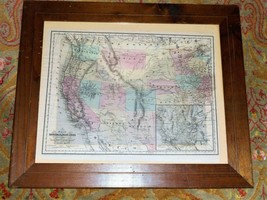
Original 1865 Map of the Territories and Pacific States to Accompany 'Across the Continent'
By Samuel Bowles
A rare and highly appealing 1865 map of the western parts of the United States drawn to illustrate Samuel Bowles' Across the Continent (New York: Hurd Houghton, 1866). The map covers from the Pacific Ocean to Illinois and the Great Lakes. It is notable for its detailed inclusion of important trans-continental emigrant routes, including the Overland Stage Route and Proposed R.R. Routes. A large inset of San Francisco Bay / California Gold Region. This map was drawn by Samuel Bowles and printed by G. W. Colton. Engraved by J. H. Goldthwait and dated 1865.
14.5" x 18.5", 24.5" x 20.5" in frame. Beautifully framed under glass in an old oak frame.
Original 1865 Sam Bowles map of the Territories and Pacific States in oak frame
Click images to enlarge
Description
Original 1865 Map of the Territories and Pacific States to Accompany 'Across the Continent'
By Samuel Bowles
A rare and highly appealing 1865 map of the western parts of the United States drawn to illustrate Samuel Bowles' Across the Continent (New York: Hurd Houghton, 1866). The map covers from the Pacific Ocean to Illinois and the Great Lakes. It is notable for its detailed inclusion of important trans-continental emigrant routes, including the Overland Stage Route and Proposed R.R. Route, Route of Central Pacific R.R., the Salt Lake and Walla Walla Mail Route, Smoky Hill express and Stage Route, and more. A large inset in the lower right quadrant focuses on the Sacramento Valley and the bustling San Francisco Bay / California Gold Region. This map was drawn by Samuel Bowles and printed by G. W. Colton. Engraved by J. H. Goldthwait and ?Entered according to Act of Congress in the Year 1865 by J. H. Goldthwait in the Clerks Office of the district Court of the U.S. for the Southern District of New York?.
14.5" x 18.5" (36.83 x 46.99 cm). 24.5" x 20.5" in frame. Scale - 1 : 7241142. Vibrant hand colored map. Beautifully framed under glass in an old oak frame.
Guarantee: We make every effort to describe our items as comprehensively and accurately as possible. It is up to you to ask questions prior to bidding - we will cheerfully answer all questions as quickly and completely as possible. Objects are sold in "as is" condition and we provide numerous pictures for your information. We offer refunds/returns if the item has been misrepresented or misdescribed and we will work with you in good faith to ensure your absolute satisfaction!
The Fine Print. Please read!
I normally ship at three times per week on Monday, Wednesday, and Friday. At end of auction, contact is expected within three days and payment is due within 5 days of auction close (10 for overseas bidders). Non-paying bidder notice after that time and item re-listed. Where possible, Delivery Confirmation (package tracking) is used and incorporated into the mailing price. Tracking is not available on international orders. Florida residents must pay 6% sales tax. I am not responsible for any accidents, injuries or other damages that arise out of the use or misuse of any item purchased. , each bidder agrees to release and hold the seller harmless from any and all losses, damages, rights, claims and actions of any kind in connection with the auction or resulting from acceptance, possession, or use of any item including, without limitation, personal injury, death, property damage and claims based on publicity rights, defamation or invasion of privacy. , each bidder agrees to all terms and conditions stated here.
Get images that
make Supersized seem small.
Showcase your items with Auctiva's
Listing Templates!
THE simple solution for sellers.
Track Page Views With
Auctiva's FREE Counter
Added to your wish list!
- Original 1865 Sam Bowles map of the Territories and Pacific States in oak frame
- 1 in stock
- Price negotiable
- Handling time 2 days. Estimated delivery: Mon, Jun 9th
Get an item reminder
We'll email you a link to your item now and follow up with a single reminder (if you'd like one). That's it! No spam, no hassle.
Already have an account?
Log in and add this item to your wish list.