Rendered at 03:27:26 07/23/25
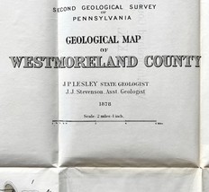


Map Coal Outcrops 1878 KKK Geological Westmoreland County Penn Victorian DWZ1
$399.99

Shipping options
Offer policy
OBO - Seller accepts offers on this item.
Details
Return policy
Purchase protection
Payment options
PayPal accepted
PayPal Credit accepted
Venmo accepted
PayPal, MasterCard, Visa, Discover, and American Express accepted
Maestro accepted
Amazon Pay accepted
Nuvei accepted
Item traits
| Category: | |
|---|---|
| Quantity Available: |
Only one in stock, order soon |
| Condition: |
Unspecified by seller, may be new. |
| Type: |
Geological Map |
| Original/Reproduction: |
Antique Original |
| Date Range: |
1800-1899 |
| Year: |
1878 |
| Country/Region: |
United States of America |
| US State: |
Pennsylvania |
| Mexican State: |
Nayarit |
| Format: |
Folding Map |
| Printing Technique: |
Lithography |
| Cartographer/Publisher: |
Lane Hart |
| City: |
Various |
| Canadian Province: |
NA |
Listing details
| Shipping discount: |
Shipping weights of all items added together for savings. |
|---|---|
| Posted for sale: |
More than a week ago |
| Item number: |
1750924865 |
Item description
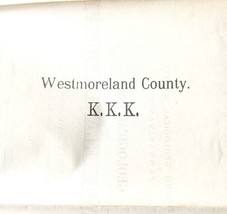
This map bears the initials of the Klu Klux Klan on the back, a very prominent group in SW Penn Bituminous coal mining and production.
How they were involved in this map is a mystery and I cannot find any history on it... whether they funded survey maps or not, I do not know. But there is no other KKK in Penn in Victorian times.
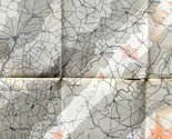
In good Victorian antique condition with less than typical wear/staining and foxing...as seen in pics. There are tears, holes in the deep creases as this map has been folded in the back of a book for about 150 years
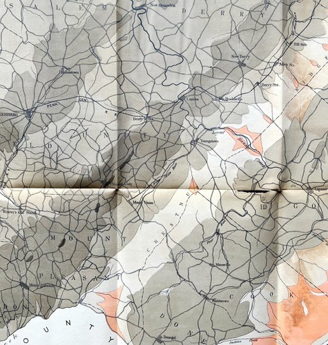
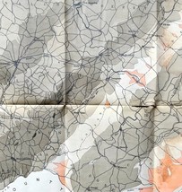
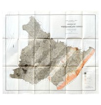
From "Geology of Southwestern Pennsylvania" volume 3, 1878 1st edition.
NOT Reproduction despite its excellent preserved condition
Approx 24.25 x 28.5"
MUST SHIP FOLDED
***Disclaimer on old/vintage/antique books/paper and the like:
Some wear from age, use and storage which may or may not include some, none or all of the following: writing/personalized notes on inside covers and title pages(or notes on pages in the case of songbooks and sheet Music), small tears, creasing, etc.... all typical Vintage and antique book wear.
Opposite side may have images or printing related to or unrelated to item shown.
See top of description for any outstanding flaws.
**All items pictured are fully usable and/or functional unless otherwise noted**
Inspect pics closely and ask any questions before buying or offering.
Tons more toys, collectibles, paper, antique, vintage ephemera, maps, engravings, prints, vinyl, vhs, media, books, bags, handmade and more!
Will combine shipping
Added to your wish list!
- Map Coal Outcrops 1878 KKK Geological Westmoreland County Penn Victorian DWZ1
- 1 in stock
- Price negotiable
Get an item reminder
We'll email you a link to your item now and follow up with a single reminder (if you'd like one). That's it! No spam, no hassle.
Already have an account?
Log in and add this item to your wish list.