HISTORIX Vintage 1912 Asheville Map - 24x36 Inch Vintage Map of Asheville North
Shipping options
Seller handling time is 2 business days Details
This reflects the seller's handling time and may not include time spent in transit.
If you have questions about shipping, please contact the seller.
FREE via to United States
Return policy
Full refund available for DOAs
Details
- We guarantee our products and offer full refunds or exchange for defective items or items not as-described.
- Buyer must contact us within 30 days after receipt of shipment.
- The item must be received in the same condition as shipped.
- Items must be returned with all original packaging and accessories.
- Items must not be abused, modified or damaged by accident.
- A 20% restocking fee will be charged for returns
- Buyer is responsible for all return shipping and handling fees.
- Restocking and return shipping fees do not apply when item is returned as defective or because incorrect product was delivered.
Payment options
PayPal accepted
PayPal Credit accepted
Venmo accepted
PayPal, MasterCard, Visa, Discover, and American Express accepted
Maestro accepted
Amazon Pay accepted
Nuvei accepted
Item traits
| Category: |
Kitchen Scales
|
| Quantity Available: |
8 in stock
|
| Condition: |
New
|
| ASIN: |
B08MQ57DMW
|
| binding: |
kitchen
|
| format: |
kitchen
|
| Map Type: |
Street
|
| Bullet Point: |
View details
VINTAGE MAP REPRODUCTION: You’ll love this high quality historic reproduction of 1912 Asheville Map. Our museum quality maps are archival grade, which means it will look great and last without fading for over 100 years. Our print to order maps are...
|
| Product Description: |
View details
Published during a time of great prosperity and population growth, this detailed bird’s eye perspective of Asheville show’s the city thriving after the turn of the century. By 1900 Asheville was the third-largest city in North Carol...
|
| Brand: |
HISTORIX
|
| Unspsc Code: |
55101500
|
| Item Type Keyword: |
prints
|
| size: |
24x36 Inch
|
| Paper Size: |
24 x 36
|
| manufacturer: |
HISTORIX
|
| Paper Finish: |
matte
|
| Item Name: |
View details
HISTORIX Vintage 1912 Asheville Map - 24x36 Inch Vintage Map of Asheville North Carolina Wall Art - Old Asheville NC Poster - Historic Asheville NC Map - Bird's Eye View Map of Asheville NC
|
| Product Site Launch Date: |
2020-11-04T05:23:52.731Z
|
| Material: |
paper
|
Listing details
|
Seller policies:
|
View seller policies
|
|
Shipping discount:
|
Seller pays shipping for this item.
|
|
Posted for sale:
|
More than a week ago
|
|
Item number:
|
1735171681
|
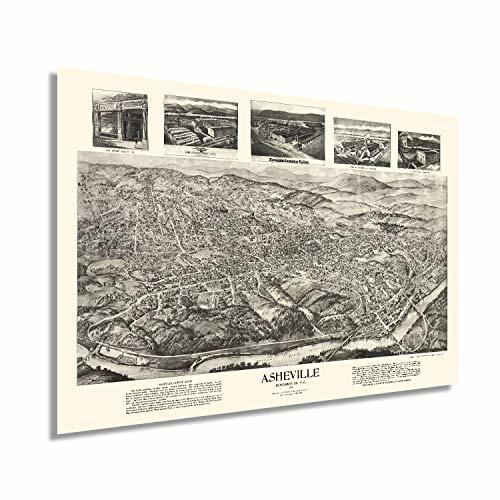
Published during a time of great prosperity and population growth, this detailed bird’s eye perspective of Asheville show’s the city thriving after the turn of the century. By 1900 Asheville was the third-largest city in North Carolina and had experienced this significant growth spurred by expanded access with the completion of the Western North Carolina Railroad. Located in the Blue Ridge Mountains, Asheville was established at the confluence of the French Broad and Swannanoa Rivers.
Produced by prominent and prolific American cartographer and illustrator Thaddeus Mortimer Fowler. He is best known for this style of bird’s eye perspective, which was wildly popular from the late nineteenth century until the 1920s. Fowler produced numerous perspectives throughout the East Coast. His work is held in collections at Pennsylvania State University, Yale, and Boston Public Library. After working for his uncle as a photographer, Fowler started his own lithography company. Bird’s eye perspectives served as marketing materials to attract residents and industrialists alike. Merchants and residents would also display them to show civic pride.
Asheville had the first electric street railway in North Carolina, which was completed in 1889; these were replaced by buses in 1934. The city’s prosperity was fueled by a robust lumber industry and a burgeoning manufacturing industry that was taking hold across the Midwest and Western regions of North Carolina. Fowler’s distinctive aesthetic and unique style immediately transports the viewer back in time, creating a link between the past and present. This is truly an authentic piece of American cartographical history.
Our museum quality giclee print comes printed with archival ink on premium heavyweight matte paper. This eye-catching vintage map reproduction print makes the perfect gift for anyone that loves history and imagery.
Additional Details
------------------------------
Bullet point: VINTAGE MAP REPRODUCTION: You?ll love this high quality historic reproduction of 1912 Asheville Map. Our museum quality maps are archival grade, which means it will look great and last without fading for over 100 years. Our print to order maps are made in the USA and each map is inspected for quality. This beautiful artwork is a perfect addition to your themed decor. Vintage maps look great in the home, study or office. They make a perfect gift as well.
Product description:
Published during a time of great prosperity and population growth, this detailed bird’s eye perspective of Asheville show’s the city thriving after the turn of the century. By 1900 Asheville was the third-largest city in North Carolina and had experienced this significant growth spurred by expanded access with the completion of the Western North Carolina Railroad. Located in the Blue Ridge Mountains, Asheville was established at the confluence of the French Broad and Swannanoa Rivers.
Produced by prominent and prolific American cartographer and illustrator Thaddeus Mortimer Fowler. He is best known for this style of bird’s eye perspective, which was wildly popular from the late nineteenth century until the 1920s. Fowler produced numerous perspectives throughout the East Coast. His work is held in collections at Pennsylvania State University, Yale, and Boston Public Library. After working for his uncle as a photographer, Fowler started his own lithography company. Bird’s eye perspectives served as marketing materials to attract residents and industrialists alike. Merchants and residents would also display them to show civic pride.
Asheville had the first electric street railway in North Carolina, which was completed in 1889; these were replaced by buses in 1934. The city’s prosperity was fueled by a robust lumber industry and a burgeoning manufacturing industry that was taking hold across the Midwest and Western regions of North Carolina. Fowler’s distinctive aesthetic and unique style immediately transports the viewer back in time, creating a link between the past and present. This is truly an authentic piece of American cartographical history.
Our museum quality giclee print comes printed with archival ink on premium heavyweight matte paper. This eye-catching vintage map reproduction print makes the perfect gift for anyone that loves history and imagery.