HISTORIX Vintage 1910 The Nile Valley Map Print - 18x24 Inch Nile Valley Map Inc
Shipping options
Seller handling time is 2 business days Details
This reflects the seller's handling time and may not include time spent in transit.
If you have questions about shipping, please contact the seller.
FREE via to United States
Return policy
Full refund available for DOAs
Details
- We guarantee our products and offer full refunds or exchange for defective items or items not as-described.
- Buyer must contact us within 30 days after receipt of shipment.
- The item must be received in the same condition as shipped.
- Items must be returned with all original packaging and accessories.
- Items must not be abused, modified or damaged by accident.
- A 20% restocking fee will be charged for returns
- Buyer is responsible for all return shipping and handling fees.
- Restocking and return shipping fees do not apply when item is returned as defective or because incorrect product was delivered.
Payment options
PayPal accepted
PayPal Credit accepted
Venmo accepted
PayPal, MasterCard, Visa, Discover, and American Express accepted
Maestro accepted
Amazon Pay accepted
Nuvei accepted
Item traits
| Category: |
Kitchen Scales
|
| Quantity Available: |
8 in stock
|
| Condition: |
New
|
| UPC: |
705514888266
|
| MPN: |
ENMAP06511824
|
| EAN: |
0705514888266
|
| Color: |
Natural
|
| binding: |
unbound
|
| format: |
unbound
|
| language: |
english
|
| manufacturer: |
HISTORIX
|
| Externally Assigned Product Identifier: |
0705514888266
|
| Bullet Point: |
View details
VINTAGE MAP REPRODUCTION: You’ll love this high quality historic reproduction of 1910 The Nile Valley Map Poster Print. Our museum quality prints are archival grade, which means it will look great and last without fading for over 100 years. Our pr...
|
| Publication Date: |
1910T
|
| Product Description: |
View details
Produced by the Edward Stanton Limited mapmaking company, which was founded in the nineteenth century and remains a respected producer to this day, this map of the Nile Valley is an essential piece of international cartographical history that b...
|
| Brand: |
HISTORIX
|
| Unspsc Code: |
55101500
|
| Paper Finish: |
matte
|
| Map Scale: |
1000
|
| Item Name: |
View details
HISTORIX Vintage 1910 The Nile Valley Map Print - 18x24 Inch Nile Valley Map Including Egypt Nubia Uganda Abyssinia British East Africa & Somali Land
|
| Item Type Keyword: |
prints
|
| Product Site Launch Date: |
2023-08-17T21:54:13.983Z
|
| Part Number: |
ENMAP06511824
|
Listing details
|
Seller policies:
|
View seller policies
|
|
Shipping discount:
|
Seller pays shipping for this item.
|
|
Posted for sale:
|
More than a week ago
|
|
Item number:
|
1735181184
|
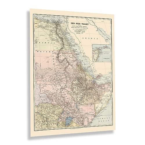
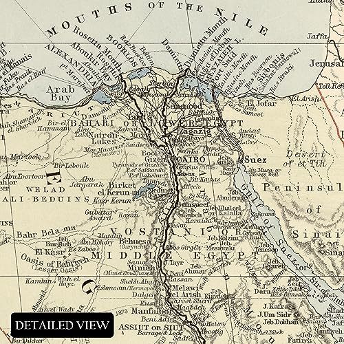
Produced by the Edward Stanton Limited mapmaking company, which was founded in the nineteenth century and remains a respected producer to this day, this map of the Nile Valley is an essential piece of international cartographical history that bears a classic aesthetic and distinctive style that immediately transports the viewer back in time creating an indelible bond between the past and present. Edward Stanford was born in 1827 and began his career as a cartographer at the age of fourteen and would go on to become one of the most prestigious British cartographers of the nineteenth century.
The Nile Valley and river have been historically considered the longest in the world, though some research in recent years disputes this claim and gives the title to the Amazon River. The Nile travels through eleven countries in Northeast Africa before reaching the Mediterranean Sea. The two main tributaries that feed the Nile, The Blue, and White Nile, begin at Lake Victoria and Lake Tana, respectively. The Nile Valley is an essential ecosystem for the region's residents and has remained an important agricultural area since the earliest inhabitants started farming the area. The northern section of the river flows almost entirely through the Nubian Desert before reaching the iconic confluence with the Mediterranean in Cairo.
This is a historic piece of international cartographic history with a rarified aesthetic that immediately transports the viewer back in time, creating a bond between the past and present of one of the most iconic places in the world.
Additional Details
------------------------------
Bullet point: VINTAGE MAP REPRODUCTION: You?ll love this high quality historic reproduction of 1910 The Nile Valley Map Poster Print. Our museum quality prints are archival grade, which means it will look great and last without fading for over 100 years. Our print to order maps are made in the USA and each map is inspected for quality. This beautiful artwork is a perfect addition to your themed decor. Vintage maps look great in the home, study or office. They make a perfect gift as well.
Product description:
Produced by the Edward Stanton Limited mapmaking company, which was founded in the nineteenth century and remains a respected producer to this day, this map of the Nile Valley is an essential piece of international cartographical history that bears a classic aesthetic and distinctive style that immediately transports the viewer back in time creating an indelible bond between the past and present. Edward Stanford was born in 1827 and began his career as a cartographer at the age of fourteen and would go on to become one of the most prestigious British cartographers of the nineteenth century.
The Nile Valley and river have been historically considered the longest in the world, though some research in recent years disputes this claim and gives the title to the Amazon River. The Nile travels through eleven countries in Northeast Africa before reaching the Mediterranean Sea. The two main tributaries that feed the Nile, The Blue, and White Nile, begin at Lake Victoria and Lake Tana, respectively. The Nile Valley is an essential ecosystem for the region's residents and has remained an important agricultural area since the earliest inhabitants started farming the area. The northern section of the river flows almost entirely through the Nubian Desert before reaching the iconic confluence with the Mediterranean in Cairo.
This is a historic piece of international cartographic history with a rarified aesthetic that immediately transports the viewer back in time, creating a bond between the past and present of one of the most iconic places in the world.
Format: wall_map