HISTORIX Vintage 1906 Casco Bay Map - 17x25 Inch Nordic Oak (Natural) Framed Vin
Shipping options
Seller handling time is 2 business days Details
This reflects the seller's handling time and may not include time spent in transit.
If you have questions about shipping, please contact the seller.
FREE via to United States
Return policy
Full refund available for DOAs
Details
- We guarantee our products and offer full refunds or exchange for defective items or items not as-described.
- Buyer must contact us within 30 days after receipt of shipment.
- The item must be received in the same condition as shipped.
- Items must be returned with all original packaging and accessories.
- Items must not be abused, modified or damaged by accident.
- A 20% restocking fee will be charged for returns
- Buyer is responsible for all return shipping and handling fees.
- Restocking and return shipping fees do not apply when item is returned as defective or because incorrect product was delivered.
Payment options
PayPal accepted
PayPal Credit accepted
Venmo accepted
PayPal, MasterCard, Visa, Discover, and American Express accepted
Maestro accepted
Amazon Pay accepted
Nuvei accepted
Item traits
| Category: |
Books & Magazines
|
| Quantity Available: |
8 in stock
|
| Condition: |
New
|
| ASIN: |
B099R3DD4H
|
| EAN: |
0693634000456
|
| UPC: |
693634000456
|
| color: |
Nordic Oak (Natural) Frame
|
| Map Type: |
Historical
|
| Externally Assigned Product Identifier: |
0693634000456
|
| Item Shape: |
Rectangular
|
| Bullet Point: |
View details
VINTAGE MAP FRAMED: You’ll love this high-quality nordic oak (natural) framed historic reproduction of 1906 Casco Bay Map. Our ready-to-hang maps are printed and framed in the USA by professional art framers using the highest quality materials. Ea...
|
| Product Description: |
View details
With an official 136 islands in the Casco Bay, it figured prominently in the War of 1812, serving as an anchorage for US Naval ships. The waters that are surrounded by Portland, Maine have long served as the primary economic driver for the city...
|
| brand: |
HISTORIX
|
| Unspsc Code: |
44103112
|
| Paper Finish: |
matte
|
| Item Name: |
View details
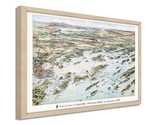
HISTORIX Vintage 1906 Casco Bay Map - 17x25 Inch Nordic Oak (Natural) Framed Vintage Casco Bay Maine Map - Old Map of Portland Maine - Bird's Eye View of Casco Bay Portland Maine & Surroundings
|
| Item Type Keyword: |
artwork
|
| Product Site Launch Date: |
2021-07-19T00:15:09.418Z
|
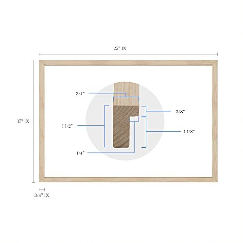
| size: |
17x25 Inch
|
| material: |
Paper
|
| style: |
Retro
|
Listing details
|
Seller policies:
|
View seller policies
|
|
Shipping discount:
|
Seller pays shipping for this item.
|
|
Posted for sale:
|
More than a week ago
|
|
Item number:
|
1735166722
|
With an official 136 islands in the Casco Bay, it figured prominently in the War of 1812, serving as an anchorage for US Naval ships. The waters that are surrounded by Portland, Maine have long served as the primary economic driver for the city, and commercial fishing is an essential industry.
Produced by George H. Walker’s lithography company in 1906, this stunning depiction shows the railroads and steamship lines that were so important to the region. Walker’s grandson and great-grandson would later both become President of the United States. The peninsula was originally settled in 1632 as a fishing and trading village. By the turn of the 20th century, the region was well known for its sailing and sport fishing.
By 1911 five railroads used the city as a hub, and it remains the largest city in Maine. These hubs were essential for the region, and goods flowed into the Northeast and Canada. The nearby town of Deering was annexed by Portland in 1899 and greatly expanded the area for development away from the shoreline.
The Grand Trunk Railroad was completed in 1852 and served as the primary source for imports to Montreal, especially crucial in the winter months when the city became inaccessible by water. This trade route was an important income source for residents of Portland, and the Portland Rail Company produced more than 600 locomotives. This stunning depiction shows the city in a time of great prosperity and is truly an authentic piece of cartographical history.
Our ready-to-hang wall art are printed and framed in the USA using the highest quality materials with professional craftsmanship. This beautiful artwork is a perfect addition to your themed decor. Historic prints look great in the home, study or office. They also make an unforgettable gift.
Additional Details
------------------------------
Bullet point: VINTAGE MAP FRAMED: You?ll love this high-quality nordic oak (natural) framed historic reproduction of 1906 Casco Bay Map. Our ready-to-hang maps are printed and framed in the USA by professional art framers using the highest quality materials. Each order is inspected for quality. This beautiful artwork is a perfect addition to your themed decor. Vintage maps look great in the home, study or office. They also make an unforgettable gift.
Product description:
With an official 136 islands in the Casco Bay, it figured prominently in the War of 1812, serving as an anchorage for US Naval ships. The waters that are surrounded by Portland, Maine have long served as the primary economic driver for the city, and commercial fishing is an essential industry.
Produced by George H. Walker’s lithography company in 1906, this stunning depiction shows the railroads and steamship lines that were so important to the region. Walker’s grandson and great-grandson would later both become President of the United States. The peninsula was originally settled in 1632 as a fishing and trading village. By the turn of the 20th century, the region was well known for its sailing and sport fishing.
By 1911 five railroads used the city as a hub, and it remains the largest city in Maine. These hubs were essential for the region, and goods flowed into the Northeast and Canada. The nearby town of Deering was annexed by Portland in 1899 and greatly expanded the area for development away from the shoreline.
The Grand Trunk Railroad was completed in 1852 and served as the primary source for imports to Montreal, especially crucial in the winter months when the city became inaccessible by water. This trade route was an important income source for residents of Portland, and the Portland Rail Company produced more than 600 locomotives. This stunning depiction shows the city in a time of great prosperity and is truly an authentic piece of cartographical history.
Our ready-to-hang wall art are printed and framed in the USA using the highest quality materials with professional craftsmanship. This beautiful artwork is a perfect addition to your themed decor. Historic prints look great in the home, study or office. They also make an unforgettable gift.