HISTORIX Vintage 1890 Davidson County North Carolina Map Print - 26x38 Inch Blac
Shipping options
Seller handling time is 2 business days Details
This reflects the seller's handling time and may not include time spent in transit.
If you have questions about shipping, please contact the seller.
FREE via to United States
Return policy
Full refund available for DOAs
Details
- We guarantee our products and offer full refunds or exchange for defective items or items not as-described.
- Buyer must contact us within 30 days after receipt of shipment.
- The item must be received in the same condition as shipped.
- Items must be returned with all original packaging and accessories.
- Items must not be abused, modified or damaged by accident.
- A 20% restocking fee will be charged for returns
- Buyer is responsible for all return shipping and handling fees.
- Restocking and return shipping fees do not apply when item is returned as defective or because incorrect product was delivered.
Payment options
PayPal accepted
PayPal Credit accepted
Venmo accepted
PayPal, MasterCard, Visa, Discover, and American Express accepted
Maestro accepted
Amazon Pay accepted
Nuvei accepted
Item traits
| Category: |
Books & Magazines
|
| Quantity Available: |
8 in stock
|
| Condition: |
New
|
| ASIN: |
B097NGB5TQ
|
| EAN: |
0723592010171
|
| UPC: |
723592010171
|
| color: |
Black Frame
|
| Map Type: |
Historical
|
| Externally Assigned Product Identifier: |
0723592010171
|
| Item Shape: |
Rectangular
|
| Bullet Point: |
View details
VINTAGE MAP FRAMED: You’ll love this high-quality black framed historic reproduction of 1890 Davidson County North Carolina Map. Our ready-to-hang maps are printed and framed in the USA by professional art framers using the highest quality materia...
|
| Product Description: |
View details
This western county of North Carolina was renamed in 1822 after Revolutionary War hero William Lee Davidson, a prominent resident and noted Continental General. Davidson was born in Pennsylvania, and his family moved to Rowan County, North Caro...
|
| brand: |
HISTORIX
|
| Unspsc Code: |
44103112
|
| Paper Finish: |
matte
|
| Item Name: |
View details
HISTORIX Vintage 1890 Davidson County North Carolina Map Print - 26x38 Inch Black Framed Vintage Map of Davidson County North Carolina Wall Art - Old Davidson NC Map Poster
|
| Item Type Keyword: |
artwork
|
| Product Site Launch Date: |
2021-06-21T16:19:25.079Z
|
| size: |
26x38 Inch
|
| material: |
Paper
|
Listing details
|
Seller policies:
|
View seller policies
|
|
Shipping discount:
|
Seller pays shipping for this item.
|
|
Posted for sale:
|
More than a week ago
|
|
Item number:
|
1735818299
|
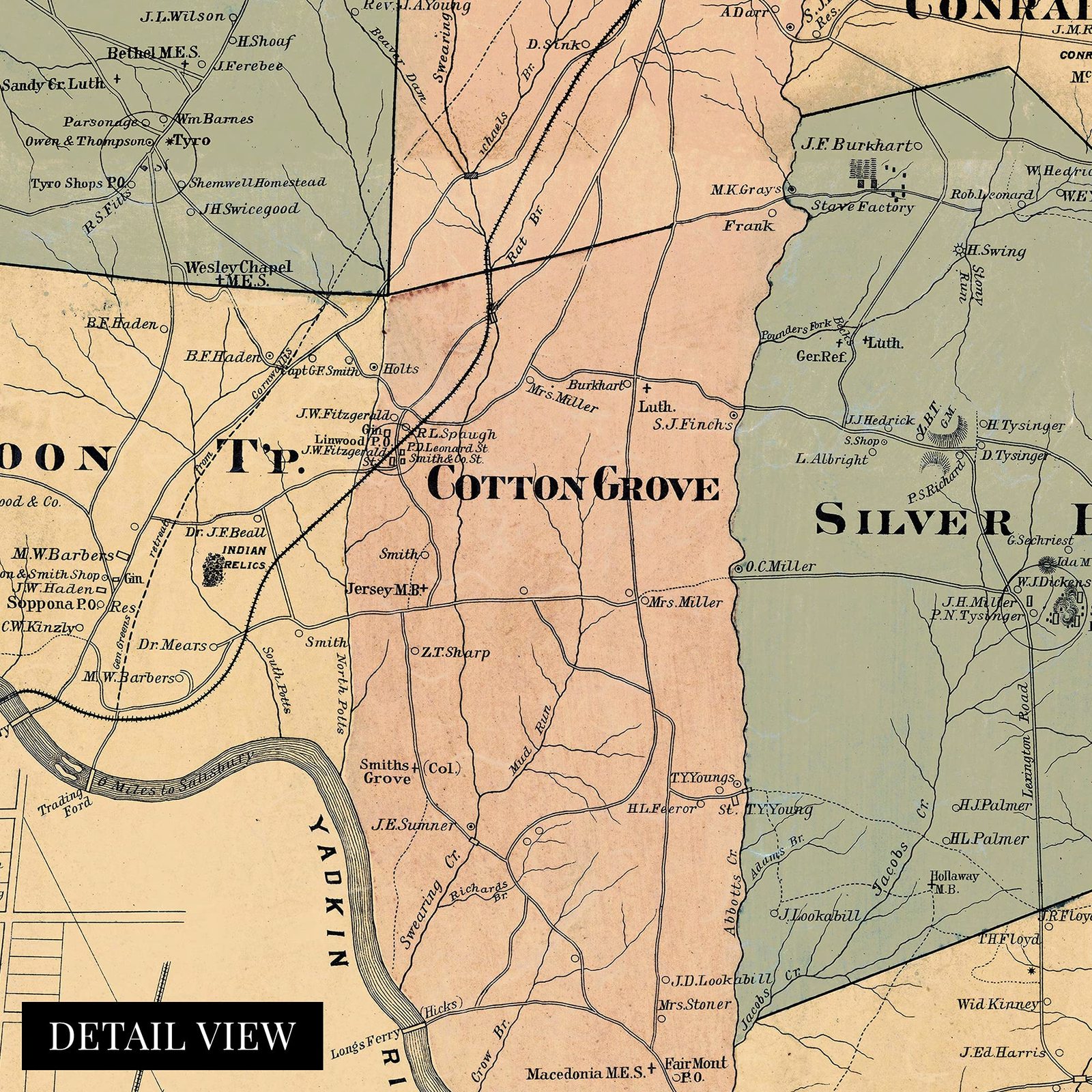
This western county of North Carolina was renamed in 1822 after Revolutionary War hero William Lee Davidson, a prominent resident and noted Continental General. Davidson was born in Pennsylvania, and his family moved to Rowan County, North Carolina in 1750. His military service began in 1775 in the 1st Rowan County in 1775, and he fought the British bravely until he died in the Battle of Cowan's Ford. The battle took place in 1781 and led to the eventual surrender of the British Army in Yorktown. The engagement is marked by the Continental armies' style of fighting, which wore the British down through a series of small conflicts. Davidson's body was recovered, and he was buried in the Hopewell Presbyterian Church north of Charlotte.
1890 was a time of economic prosperity in North Carolina with tobacco exports driving the boom. These maps are a valuable tool for genealogists and historians to develop a picture of American life in the late 19th century. This unique depiction of the county highlights notable buildings as well as churches and details Yadkin College.
North Carolina had recovered from the destruction of the Civil War at this time and was rapidly developing. Lexington, the county seat, was the home to the first silver mine in the United States, and the discovery of gold in the area in 1799 sparked the famed American gold rush, which would spur on the settlement of the vast American west. This distinct illustration is an authentic piece of cartographical history.
Our ready-to-hang wall art are printed and framed in the USA using the highest quality materials with professional craftsmanship. This beautiful artwork is a perfect addition to your themed decor. Historic prints look great in the home, study or office. They also make an unforgettable gift.
Additional Details
------------------------------
Bullet point: VINTAGE MAP FRAMED: You?ll love this high-quality black framed historic reproduction of 1890 Davidson County North Carolina Map. Our ready-to-hang maps are printed and framed in the USA by professional art framers using the highest quality materials. Each order is inspected for quality. This beautiful artwork is a perfect addition to your themed decor. Vintage maps look great in the home, study or office. They also make an unforgettable gift.
Product description:
This western county of North Carolina was renamed in 1822 after Revolutionary War hero William Lee Davidson, a prominent resident and noted Continental General. Davidson was born in Pennsylvania, and his family moved to Rowan County, North Carolina in 1750. His military service began in 1775 in the 1st Rowan County in 1775, and he fought the British bravely until he died in the Battle of Cowan's Ford. The battle took place in 1781 and led to the eventual surrender of the British Army in Yorktown. The engagement is marked by the Continental armies' style of fighting, which wore the British down through a series of small conflicts. Davidson's body was recovered, and he was buried in the Hopewell Presbyterian Church north of Charlotte.
1890 was a time of economic prosperity in North Carolina with tobacco exports driving the boom. These maps are a valuable tool for genealogists and historians to develop a picture of American life in the late 19th century. This unique depiction of the county highlights notable buildings as well as churches and details Yadkin College.
North Carolina had recovered from the destruction of the Civil War at this time and was rapidly developing. Lexington, the county seat, was the home to the first silver mine in the United States, and the discovery of gold in the area in 1799 sparked the famed American gold rush, which would spur on the settlement of the vast American west. This distinct illustration is an authentic piece of cartographical history.
Our ready-to-hang wall art are printed and framed in the USA using the highest quality materials with professional craftsmanship. This beautiful artwork is a perfect addition to your themed decor. Historic prints look great in the home, study or office. They also make an unforgettable gift.