HISTORIX Vintage 1889 Multnomah County Oregon Map - 13x25 Inch Light Walnut Fram
Shipping options
Seller handling time is 2 business days Details
This reflects the seller's handling time and may not include time spent in transit.
If you have questions about shipping, please contact the seller.
FREE via to United States
Return policy
Full refund available for DOAs
Details
- We guarantee our products and offer full refunds or exchange for defective items or items not as-described.
- Buyer must contact us within 30 days after receipt of shipment.
- The item must be received in the same condition as shipped.
- Items must be returned with all original packaging and accessories.
- Items must not be abused, modified or damaged by accident.
- A 20% restocking fee will be charged for returns
- Buyer is responsible for all return shipping and handling fees.
- Restocking and return shipping fees do not apply when item is returned as defective or because incorrect product was delivered.
Payment options
PayPal accepted
PayPal Credit accepted
Venmo accepted
PayPal, MasterCard, Visa, Discover, and American Express accepted
Maestro accepted
Amazon Pay accepted
Nuvei accepted
Item traits
| Category: |
Books & Magazines
|
| Quantity Available: |
8 in stock
|
| Condition: |
New
|
| ASIN: |
B0965W663N
|
| EAN: |
0723592007560
|
| UPC: |
723592007560
|
| color: |
Light Walnut Frame
|
| Externally Assigned Product Identifier: |
0723592007560
|
| Item Shape: |
Rectangular
|
| Bullet Point: |
View details
VINTAGE MAP FRAMED: You’ll love this high-quality light walnut framed historic reproduction of 1889 Multnomah County Oregon Map. Our ready-to-hang maps are printed and framed in the USA by professional art framers using the highest quality materia...
|
| Product Description: |
View details
This map was produced by Julius Bien, a German-born American lithographer with a distinctive style. The superior technical illustration expertise marks Bien's legacy. Bien also illustrated and printed Audubon's famous work, The Birds of America...
|
| brand: |
HISTORIX
|
| Unspsc Code: |
55101500
|
| Item Name: |
View details
HISTORIX Vintage 1889 Multnomah County Oregon Map - 13x25 Inch Light Walnut Framed Vintage Multnomah Wall Art - Old Map of Oregon Poster - History Map of Multnomah County Oregon Wall Art
|
| Item Type Keyword: |
artwork
|
| Product Site Launch Date: |
2021-05-29T20:00:26.814Z
|
| material: |
Paper
|
| size: |
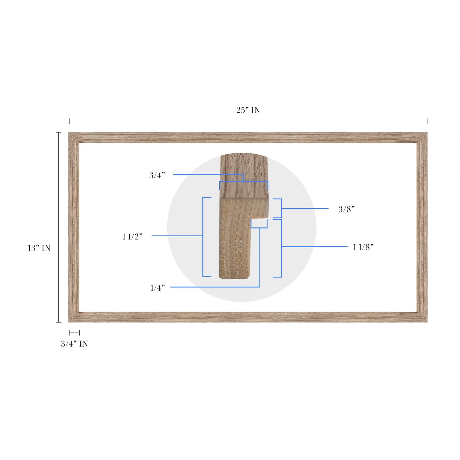
13x25 Inch
|
| style: |
Victorian
|
Listing details
|
Seller policies:
|
View seller policies
|
|
Shipping discount:
|
Seller pays shipping for this item.
|
|
Posted for sale:
|
More than a week ago
|
|
Item number:
|
1735846159
|
This map was produced by Julius Bien, a German-born American lithographer with a distinctive style. The superior technical illustration expertise marks Bien's legacy. Bien also illustrated and printed Audubon's famous work, The Birds of America. He utilized the latest science of the time to produce maps with extremely accurate scale and detail, printed using a technique called chromolithography and stunningly depicted in this 1889 illustration of Multnomah County.
The county gets its name from the Chinookan word for 'lower river,' and while geographically the smallest county in Oregon, it is the most populous. Though still notated as East Portland here, the two cities had incorporated in 1871. The historical Barber Block building was completed in 1889 and is recognized for its late Victorian architecture.
This cadastral map, which illustrates the boundaries and ownership of land parcels, shows Portland in a time of significant expansion. Already a thriving inland port with ocean access via the Columbia and Willamette Rivers. Though this was a substantial reason for the cities prosperity, it also contributed to its reputation as a dangerous place with a high number of saloons, bordellos, and gambling dens; its character as a sober frontier city had been lost.
Portland's population increased in the late 20th century with nearly fifty thousand residents by 1889 it was experiencing an economic boom and was the largest port in the Northwest. These maps were an essential tool for merchants and residents alike, and the signature aesthetic transports the viewer back in time.
Our ready-to-hang wall art are printed and framed in the USA using the highest quality materials with professional craftsmanship. This beautiful artwork is a perfect addition to your themed decor. Historic prints look great in the home, study or office. They also make an unforgettable gift.
Additional Details
------------------------------
Bullet point: VINTAGE MAP FRAMED: You?ll love this high-quality light walnut framed historic reproduction of 1889 Multnomah County Oregon Map. Our ready-to-hang maps are printed and framed in the USA by professional art framers using the highest quality materials. Each order is inspected for quality. This beautiful artwork is a perfect addition to your themed decor. Vintage maps look great in the home, study or office. They also make an unforgettable gift.
Product description:
This map was produced by Julius Bien, a German-born American lithographer with a distinctive style. The superior technical illustration expertise marks Bien's legacy. Bien also illustrated and printed Audubon's famous work, The Birds of America. He utilized the latest science of the time to produce maps with extremely accurate scale and detail, printed using a technique called chromolithography and stunningly depicted in this 1889 illustration of Multnomah County.
The county gets its name from the Chinookan word for 'lower river,' and while geographically the smallest county in Oregon, it is the most populous. Though still notated as East Portland here, the two cities had incorporated in 1871. The historical Barber Block building was completed in 1889 and is recognized for its late Victorian architecture.
This cadastral map, which illustrates the boundaries and ownership of land parcels, shows Portland in a time of significant expansion. Already a thriving inland port with ocean access via the Columbia and Willamette Rivers. Though this was a substantial reason for the cities prosperity, it also contributed to its reputation as a dangerous place with a high number of saloons, bordellos, and gambling dens; its character as a sober frontier city had been lost.
Portland's population increased in the late 20th century with nearly fifty thousand residents by 1889 it was experiencing an economic boom and was the largest port in the Northwest. These maps were an essential tool for merchants and residents alike, and the signature aesthetic transports the viewer back in time.
Our ready-to-hang wall art are printed and framed in the USA using the highest quality materials with professional craftsmanship. This beautiful artwork is a perfect addition to your themed decor. Historic prints look great in the home, study or office. They also make an unforgettable gift.