HISTORIX Vintage 1868 Saint Joseph Missouri Map Poster - 18x24 Inch Vintage Bird
Shipping options
Seller handling time is 2 business days Details
This reflects the seller's handling time and may not include time spent in transit.
If you have questions about shipping, please contact the seller.
FREE via to United States
Return policy
Full refund available for DOAs
Details
- We guarantee our products and offer full refunds or exchange for defective items or items not as-described.
- Buyer must contact us within 30 days after receipt of shipment.
- The item must be received in the same condition as shipped.
- Items must be returned with all original packaging and accessories.
- Items must not be abused, modified or damaged by accident.
- A 20% restocking fee will be charged for returns
- Buyer is responsible for all return shipping and handling fees.
- Restocking and return shipping fees do not apply when item is returned as defective or because incorrect product was delivered.
Payment options
PayPal accepted
PayPal Credit accepted
Venmo accepted
PayPal, MasterCard, Visa, Discover, and American Express accepted
Maestro accepted
Amazon Pay accepted
Nuvei accepted
Item traits
| Category: |
Kitchen Scales
|
| Quantity Available: |
8 in stock
|
| Condition: |
New
|
| UPC: |
705514886248
|
| MPN: |
ENMAP0622_1824
|
| ASIN: |
B0C4DD29MJ
|
| EAN: |
0705514886248
|
| Age Range Description: |
Adult
|
| Bullet Point: |
View details
VINTAGE MAP REPRODUCTION: You’ll love this high quality historic reproduction of 1868 Saint Joseph Missouri Wall Map Poster. Our museum quality prints are archival grade, which means it will look great and last without fading for over 100 years. O...
|
| Product Description: |
View details
Located on the banks of the Missouri River, Saint Joseph, Missouri, was the furthest west town that could be reached by rail in the United States until rail expansion occurred after the end of the Civil War. Officially incorporated in 1843, Sai...
|
| Brand: |
HISTORIX
|
| Unspsc Code: |
55101500
|
| Externally Assigned Product Identifier: |
705514886248
|
| Item Type Keyword: |
artwork
|
| size: |
36L" x 24W"
|
| Paper Size: |
18 x 24
|
| Part Number: |
ENMAP0622_1824
|
| Style: |
Classic
|
| Wall Art Form: |
poster
|
| Target Gender: |
unisex
|
| Color: |
Natural
|
| manufacturer: |
historix
|
| Item Shape: |
Rectangular
|
| orientation: |
Landscape
|
| Paper Finish: |
matte
|
| Item Name: |
View details
HISTORIX Vintage 1868 Saint Joseph Missouri Map Poster - 18x24 Inch Vintage Bird's Eye View of the City of St Joseph Missouri Wall Art Map Print
|
| Material: |
Paper
|
| Mounting Type: |
Wall Mount
|
| Room Type: |
Office
|
Listing details
|
Seller policies:
|
View seller policies
|
|
Shipping discount:
|
Seller pays shipping for this item.
|
|
Posted for sale:
|
More than a week ago
|
|
Item number:
|
1735819726
|
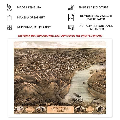
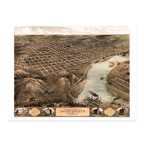
Located on the banks of the Missouri River, Saint Joseph, Missouri, was the furthest west town that could be reached by rail in the United States until rail expansion occurred after the end of the Civil War. Officially incorporated in 1843, Saint Joseph earned a reputation as a rugged frontier town that was the last point before you entered the so-called Wild West and maintained a bustling outpost that outfitted travelers as they began their journey, often to the Oregon territories. In the years following the conclusion of the Civil War, the city saw an influx of residents from across the United States and Eastern and Western Europe who established towns and communities based on shared traditions, many of which exist to this day.
Saint Joseph is located across from the eastern boundary of Kansas and has a rich history, including being home to outlaw Jesse James for a brief time. Produced and published by an early adopter of the form, Albert Ruger, this bird's eye perspective was used as a way to market the town to potential residents and merchants alike and featured prominent civic features, natural attractions, and economic opportunities. Panoramic maps bear a distinct aesthetic and classic style, and Ruger's use of bold colors set his work apart from other producers of the time.
Bird's eye perspectives were widely popular during the latter portions of the nineteenth century and early parts of the twentieth century. This is a unique piece of nineteenth-century American cartographical history.
Additional Details
------------------------------
Bullet point: VINTAGE MAP REPRODUCTION: You?ll love this high quality historic reproduction of 1868 Saint Joseph Missouri Wall Map Poster. Our museum quality prints are archival grade, which means it will look great and last without fading for over 100 years. Our print to order maps are made in the USA and each map is inspected for quality. This beautiful artwork is a perfect addition to your themed decor. Vintage maps look great in the home, study or office. They make a perfect gift as well.
Product description:
Located on the banks of the Missouri River, Saint Joseph, Missouri, was the furthest west town that could be reached by rail in the United States until rail expansion occurred after the end of the Civil War. Officially incorporated in 1843, Saint Joseph earned a reputation as a rugged frontier town that was the last point before you entered the so-called Wild West and maintained a bustling outpost that outfitted travelers as they began their journey, often to the Oregon territories. In the years following the conclusion of the Civil War, the city saw an influx of residents from across the United States and Eastern and Western Europe who established towns and communities based on shared traditions, many of which exist to this day.
Saint Joseph is located across from the eastern boundary of Kansas and has a rich history, including being home to outlaw Jesse James for a brief time. Produced and published by an early adopter of the form, Albert Ruger, this bird's eye perspective was used as a way to market the town to potential residents and merchants alike and featured prominent civic features, natural attractions, and economic opportunities. Panoramic maps bear a distinct aesthetic and classic style, and Ruger's use of bold colors set his work apart from other producers of the time.
Bird's eye perspectives were widely popular during the latter portions of the nineteenth century and early parts of the twentieth century. This is a unique piece of nineteenth-century American cartographical history.