HISTORIX Vintage 1868 Independence Jackson County Missouri Wall Map Print - 24x3
Shipping options
Seller handling time is 2 business days Details
This reflects the seller's handling time and may not include time spent in transit.
If you have questions about shipping, please contact the seller.
FREE via to United States
Return policy
Full refund available for DOAs
Details
- We guarantee our products and offer full refunds or exchange for defective items or items not as-described.
- Buyer must contact us within 30 days after receipt of shipment.
- The item must be received in the same condition as shipped.
- Items must be returned with all original packaging and accessories.
- Items must not be abused, modified or damaged by accident.
- A 20% restocking fee will be charged for returns
- Buyer is responsible for all return shipping and handling fees.
- Restocking and return shipping fees do not apply when item is returned as defective or because incorrect product was delivered.
Payment options
PayPal accepted
PayPal Credit accepted
Venmo accepted
PayPal, MasterCard, Visa, Discover, and American Express accepted
Maestro accepted
Amazon Pay accepted
Nuvei accepted
Item traits
| Category: |
Kitchen Scales
|
| Quantity Available: |
8 in stock
|
| Condition: |
New
|
| UPC: |
705514886781
|
| Style: |
Vintage/Retro
|
| ASIN: |
B0C6FV2DCT
|
| EAN: |
0705514886781
|
| Paint Type: |
Watercolor
|
| Color: |
Natural
|
| Pattern: |
Printed
|
| Externally Assigned Product Identifier: |
0705514886781
|
| Item Shape: |
Rectangular
|
| Age Range Description: |
Adult
|
| Bullet Point: |
View details
VINTAGE MAP REPRODUCTION: You’ll love this high quality historic reproduction of 1868 Independence Jackson County Missouri Map Poster. Our museum quality prints are archival grade, which means it will look great and last without fading for over 10...
|
| theme: |
Map
|
| Product Description: |
View details
The fifth-largest city in Missouri and part of the Kansas City metropolitan area, Jackson was experiencing a period of significant growth and transformation following the conclusion of the Civil War. Independence was known as the "Queen City of...
|
| Brand: |
HISTORIX
|
| Supplier Declared Dg Hz Regulation: |
not_applicable
|
| Unspsc Code: |
60121000
|
| orientation: |
Landscape
|
| Paper Finish: |
matte
|
| Item Name: |
View details
HISTORIX Vintage 1868 Independence Jackson County Missouri Wall Map Print - 24x30 Inch Vintage Bird's Eye View Map of Independence Missouri Wall Art Poster
|
| Item Type Keyword: |
artwork
|
| Mounting Type: |
Wall Mount
|
| size: |
24L" x 36W"
|
| Material: |
Paper
|
| Paper Size: |
24 x 30
|
| Wall Art Form: |
poster
|
| Target Gender: |
unisex
|
Listing details
|
Seller policies:
|
View seller policies
|
|
Shipping discount:
|
Seller pays shipping for this item.
|
|
Posted for sale:
|
More than a week ago
|
|
Item number:
|
1735823222
|
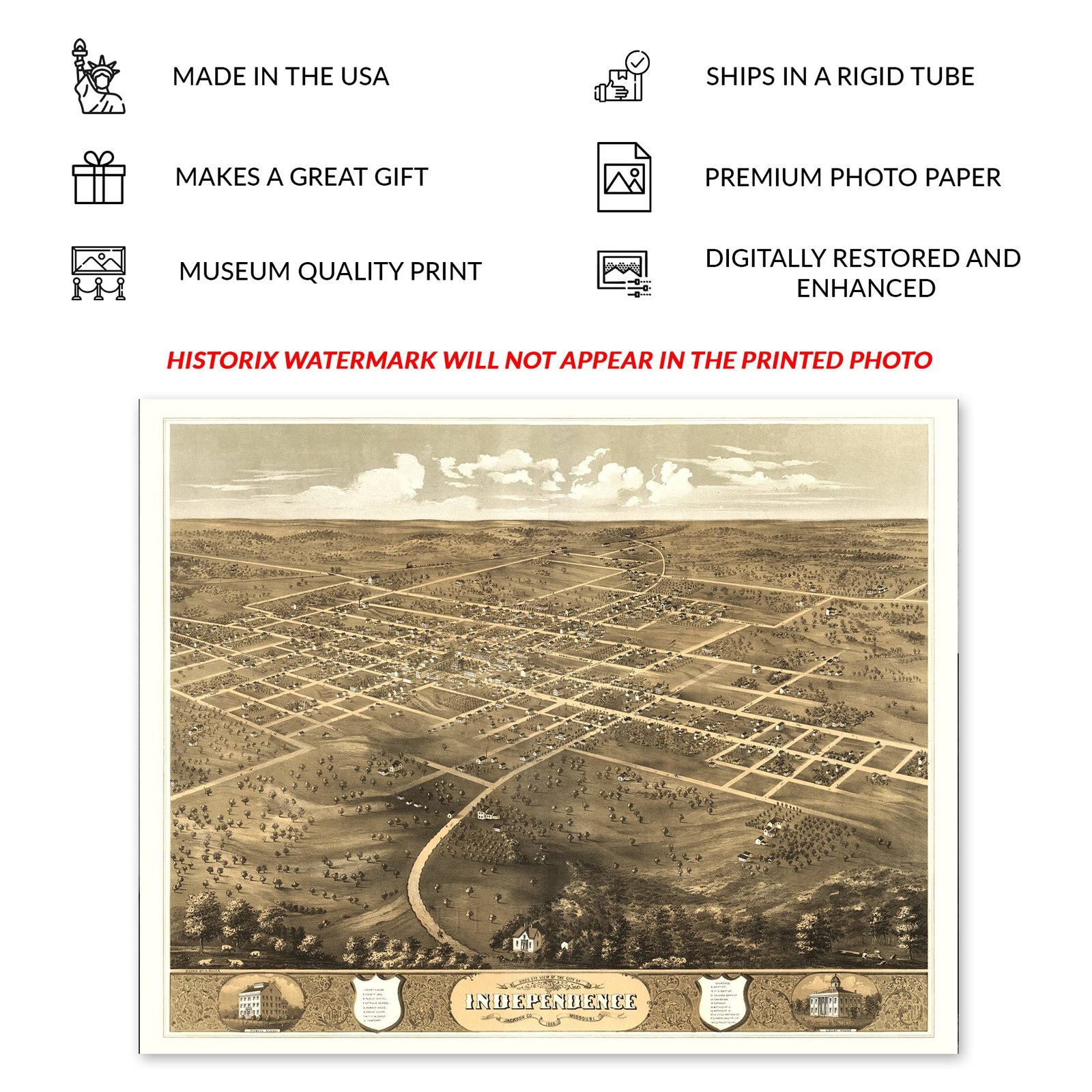
The fifth-largest city in Missouri and part of the Kansas City metropolitan area, Jackson was experiencing a period of significant growth and transformation following the conclusion of the Civil War. Independence was known as the "Queen City of the Trails" due to its location as the departure point for settlers making their way across the American West en route to destinations in the Pacific Northwest and California seeking to establish neighborhoods and communities. Independence was officially established in 1827 though it had been growing since the region was acquired in the Louisiana Purchase in 1803 in a deal brokered by Thomas Jefferson that would transform the American landscape permanently.
This bird's eye perspective was produced by one of the early adopters of the form Albert Ruger and bears his distinctive style and aesthetic. Panoramic maps were used as marketing materials to promote towns and cities across the nation and featured attractive economic opportunities and notable buildings to entice residents and merchants alike. Ruger's works inspired numerous other illustrators, and bird's eye perspectives would become some of the most popular works during the middle of the nineteenth and early twentieth century. Ruger primarily focused on the Midwest, as his firm was based in Chicago.
This panoramic map immediately transports the viewer back in time, creating an indelible bond between the past and present. During the 1860s, Independence had become a prosperous city with numerous outfitters giving settlers the last opportunity to stock up on provisions before starting their arduous journey West.
Additional Details
------------------------------
Bullet point: VINTAGE MAP REPRODUCTION: You?ll love this high quality historic reproduction of 1868 Independence Jackson County Missouri Map Poster. Our museum quality prints are archival grade, which means it will look great and last without fading for over 100 years. Our print to order maps are made in the USA and each map is inspected for quality. This beautiful artwork is a perfect addition to your themed decor. Vintage maps look great in the home, study or office. They make a perfect gift as well.
Product description:
The fifth-largest city in Missouri and part of the Kansas City metropolitan area, Jackson was experiencing a period of significant growth and transformation following the conclusion of the Civil War. Independence was known as the "Queen City of the Trails" due to its location as the departure point for settlers making their way across the American West en route to destinations in the Pacific Northwest and California seeking to establish neighborhoods and communities. Independence was officially established in 1827 though it had been growing since the region was acquired in the Louisiana Purchase in 1803 in a deal brokered by Thomas Jefferson that would transform the American landscape permanently.
This bird's eye perspective was produced by one of the early adopters of the form Albert Ruger and bears his distinctive style and aesthetic. Panoramic maps were used as marketing materials to promote towns and cities across the nation and featured attractive economic opportunities and notable buildings to entice residents and merchants alike. Ruger's works inspired numerous other illustrators, and bird's eye perspectives would become some of the most popular works during the middle of the nineteenth and early twentieth century. Ruger primarily focused on the Midwest, as his firm was based in Chicago.
This panoramic map immediately transports the viewer back in time, creating an indelible bond between the past and present. During the 1860s, Independence had become a prosperous city with numerous outfitters giving settlers the last opportunity to stock up on provisions before starting their arduous journey West.
Style: Retro