HISTORIX Vintage 1865 South Carolina Map - 19x25 Inch Black Framed Vintage South
Shipping options
Seller handling time is 2 business days Details
This reflects the seller's handling time and may not include time spent in transit.
If you have questions about shipping, please contact the seller.
FREE via to United States
Return policy
Full refund available for DOAs
Details
- We guarantee our products and offer full refunds or exchange for defective items or items not as-described.
- Buyer must contact us within 30 days after receipt of shipment.
- The item must be received in the same condition as shipped.
- Items must be returned with all original packaging and accessories.
- Items must not be abused, modified or damaged by accident.
- A 20% restocking fee will be charged for returns
- Buyer is responsible for all return shipping and handling fees.
- Restocking and return shipping fees do not apply when item is returned as defective or because incorrect product was delivered.
Payment options
PayPal accepted
PayPal Credit accepted
Venmo accepted
PayPal, MasterCard, Visa, Discover, and American Express accepted
Maestro accepted
Amazon Pay accepted
Nuvei accepted
Item traits
| Category: |
Books & Magazines
|
| Quantity Available: |
8 in stock
|
| Condition: |
New
|
| ASIN: |
B09BG28M66
|
| EAN: |
0693634001316
|
| UPC: |
693634001316
|
| color: |
Black Frame
|
| Map Type: |
Historical
|
| Externally Assigned Product Identifier: |
0693634001316
|
| Item Shape: |
Rectangular
|
| Bullet Point: |
View details
VINTAGE MAP FRAMED: You’ll love this high-quality black framed historic reproduction of 1865 South Carolina Map. Our ready-to-hang maps are printed and framed in the USA by professional art framers using the highest quality materials. Each order i...
|
| Product Description: |
View details
Based on depictions of the region from the decade prior, this map was published in 1865 at the close of the American Civil War and produced by prominent American cartographer and publisher J.H. Colton. Colton employed a more costly steel engrav...
|
| brand: |
HISTORIX
|
| Unspsc Code: |
55101500
|
| Paper Finish: |
matte
|
| Item Name: |
View details
HISTORIX Vintage 1865 South Carolina Map - 19x25 Inch Black Framed Vintage South Carolina Wall Art - Old South Carolina State Map - Restored Map of SC - Colton's South Carolina Wall Map
|
| Item Type Keyword: |
artwork
|
| Product Site Launch Date: |
2021-07-29T14:28:56.747Z
|
| size: |
19x25 Inch
|
| material: |
Paper
|
| style: |
Retro
|
Listing details
|
Seller policies:
|
View seller policies
|
|
Shipping discount:
|
Seller pays shipping for this item.
|
|
Posted for sale:
|
More than a week ago
|
|
Item number:
|
1735192311
|
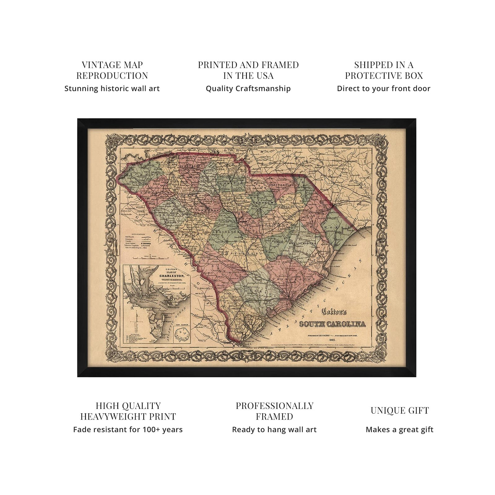
Based on depictions of the region from the decade prior, this map was published in 1865 at the close of the American Civil War and produced by prominent American cartographer and publisher J.H. Colton. Colton employed a more costly steel engraving method that was then colored by hand, and his maps were known for their premium quality, extensive detailing, and distinctive aesthetic. This map also features the signature border that Colton maps were known for.
The decision to depict the city of Charleston and also Fort Sumter, given the period, is unique given the former’s role at the start of the Civil War. Charleston’s history is deep, and the city had been experiencing great prosperity during the antebellum due to its bustling ports. Charleston was a key fortification point for the Confederacy, and it did not fall to Union Forces until the very last months of the Civil War.
This handsome depiction of the state shows it in a time of great transition, and these maps were often produced for markets in Western Europe. Europeans had become fascinated with the results of the American Civil War. They were eager to display locations that had historical significance, and South Carolina was easily one of the most symbolic.
This is truly an authentic piece of cartographical history, and the extensive details in Colton’s publication allow historians to gain greater insight into the daily lives of prominent South Carolinians and how their lives had been altered in the period stretching from antebellum to reconstruction.
Our ready-to-hang wall art are printed and framed in the USA using the highest quality materials with professional craftsmanship. This beautiful artwork is a perfect addition to your themed decor. Historic prints look great in the home, study or office. They also make an unforgettable gift.
Additional Details
------------------------------
Bullet point: VINTAGE MAP FRAMED: You?ll love this high-quality black framed historic reproduction of 1865 South Carolina Map. Our ready-to-hang maps are printed and framed in the USA by professional art framers using the highest quality materials. Each order is inspected for quality. This beautiful artwork is a perfect addition to your themed decor. Vintage maps look great in the home, study or office. They also make an unforgettable gift.
Product description:
Based on depictions of the region from the decade prior, this map was published in 1865 at the close of the American Civil War and produced by prominent American cartographer and publisher J.H. Colton. Colton employed a more costly steel engraving method that was then colored by hand, and his maps were known for their premium quality, extensive detailing, and distinctive aesthetic. This map also features the signature border that Colton maps were known for.
The decision to depict the city of Charleston and also Fort Sumter, given the period, is unique given the former’s role at the start of the Civil War. Charleston’s history is deep, and the city had been experiencing great prosperity during the antebellum due to its bustling ports. Charleston was a key fortification point for the Confederacy, and it did not fall to Union Forces until the very last months of the Civil War.
This handsome depiction of the state shows it in a time of great transition, and these maps were often produced for markets in Western Europe. Europeans had become fascinated with the results of the American Civil War. They were eager to display locations that had historical significance, and South Carolina was easily one of the most symbolic.
This is truly an authentic piece of cartographical history, and the extensive details in Colton’s publication allow historians to gain greater insight into the daily lives of prominent South Carolinians and how their lives had been altered in the period stretching from antebellum to reconstruction.
Our ready-to-hang wall art are printed and framed in the USA using the highest quality materials with professional craftsmanship. This beautiful artwork is a perfect addition to your themed decor. Historic prints look great in the home, study or office. They also make an unforgettable gift.