HISTORIX Vintage 1861 Military Map of The United States - 25x33 Inch Light Walnu
Shipping options
Seller handling time is 2 business days Details
This reflects the seller's handling time and may not include time spent in transit.
If you have questions about shipping, please contact the seller.
FREE via to United States
Return policy
Full refund available for DOAs
Details
- We guarantee our products and offer full refunds or exchange for defective items or items not as-described.
- Buyer must contact us within 30 days after receipt of shipment.
- The item must be received in the same condition as shipped.
- Items must be returned with all original packaging and accessories.
- Items must not be abused, modified or damaged by accident.
- A 20% restocking fee will be charged for returns
- Buyer is responsible for all return shipping and handling fees.
- Restocking and return shipping fees do not apply when item is returned as defective or because incorrect product was delivered.
Payment options
PayPal accepted
PayPal Credit accepted
Venmo accepted
PayPal, MasterCard, Visa, Discover, and American Express accepted
Maestro accepted
Amazon Pay accepted
Nuvei accepted
Item traits
| Category: |
Books & Magazines
|
| Quantity Available: |
8 in stock
|
| Condition: |
New
|
| ASIN: |
B096ZGHYR3
|
| EAN: |
0723592009410
|
| UPC: |
723592009410
|
| color: |
Light Walnut Frame
|
| Map Type: |
Historical
|
| Externally Assigned Product Identifier: |
0723592009410
|
| Item Shape: |
Rectangular
|
| Bullet Point: |
View details
VINTAGE MAP FRAMED: You’ll love this high-quality light walnut framed historic reproduction of 1861 Military Map of The United States. Our ready-to-hang maps are printed and framed in the USA by professional art framers using the highest quality m...
|
| Product Description: |
View details
This military map produced at the beginning of the Civil War illustrates strategic ports and military installations. Illustrated and published by prominent lithographer and mapmaker Peter Duval, this map is a compilation of public data and allo...
|
| brand: |
HISTORIX
|
| Unspsc Code: |
55101500
|
| Paper Finish: |
matte
|
| Item Name: |
View details
HISTORIX Vintage 1861 Military Map of The United States - 25x33 Inch Light Walnut Framed Vintage United States Map - Restored USA Map Poster - Old Military Map of United States & Territories
|
| Item Type Keyword: |
artwork
|
| Product Site Launch Date: |
2021-06-10T06:08:33.847Z
|
| material: |
Paper
|
| size: |
25x33 Inch
|
Listing details
|
Seller policies:
|
View seller policies
|
|
Shipping discount:
|
Seller pays shipping for this item.
|
|
Posted for sale:
|
More than a week ago
|
|
Item number:
|
1735817998
|
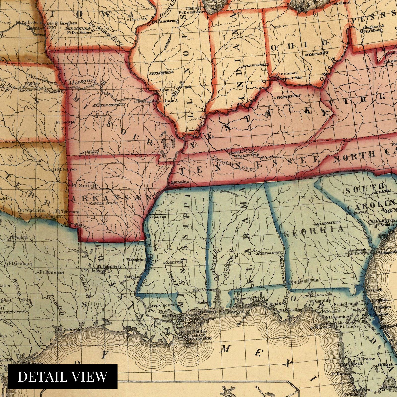
This military map produced at the beginning of the Civil War illustrates strategic ports and military installations. Illustrated and published by prominent lithographer and mapmaker Peter Duval, this map is a compilation of public data and allowed military leaders to prepare a strategy for the conflict that would reshape American history forever.
The secession of the southern states in 1861 marked a turning point in an already tense time, and the Union military had readied itself to combat the insurgent South. The loose organization of the Confederate States had called on men from across the South to bear arms and prepare for the inevitable invasion by Union forces.
Shortly after Lincoln’s election, secessionist forces attacked Fort Sumter in South Carolina, and the war officially broke out in April of 1861. The US Navy at the beginning of the war was enlarged to six thousand officers and forty-five thousand enlisted men and became a crucial part of the Union’s success. By establishing and maintaining blockades, the Union gained a valuable upper hand on the ports that were essential for the Southern states, critically establishing a Union presence at the mouth of the Mississippi River.
The Civil War allowed for the development of what would become the modern US Navy and the construction of well-armored ironclad warships as the war had broken out at the beginning of the industrial revolution. The distinct aesthetic and wealth of information provided by this map offer the viewer a glimpse into the past, and it is an authentic piece of cartographical history.
Our ready-to-hang wall art are printed and framed in the USA using the highest quality materials with professional craftsmanship. This beautiful artwork is a perfect addition to your themed decor. Historic prints look great in the home, study or office. They also make an unforgettable gift.
Additional Details
------------------------------
Bullet point: VINTAGE MAP FRAMED: You?ll love this high-quality light walnut framed historic reproduction of 1861 Military Map of The United States. Our ready-to-hang maps are printed and framed in the USA by professional art framers using the highest quality materials. Each order is inspected for quality. This beautiful artwork is a perfect addition to your themed decor. Vintage maps look great in the home, study or office. They also make an unforgettable gift.
Product description:
This military map produced at the beginning of the Civil War illustrates strategic ports and military installations. Illustrated and published by prominent lithographer and mapmaker Peter Duval, this map is a compilation of public data and allowed military leaders to prepare a strategy for the conflict that would reshape American history forever.
The secession of the southern states in 1861 marked a turning point in an already tense time, and the Union military had readied itself to combat the insurgent South. The loose organization of the Confederate States had called on men from across the South to bear arms and prepare for the inevitable invasion by Union forces.
Shortly after Lincoln’s election, secessionist forces attacked Fort Sumter in South Carolina, and the war officially broke out in April of 1861. The US Navy at the beginning of the war was enlarged to six thousand officers and forty-five thousand enlisted men and became a crucial part of the Union’s success. By establishing and maintaining blockades, the Union gained a valuable upper hand on the ports that were essential for the Southern states, critically establishing a Union presence at the mouth of the Mississippi River.
The Civil War allowed for the development of what would become the modern US Navy and the construction of well-armored ironclad warships as the war had broken out at the beginning of the industrial revolution. The distinct aesthetic and wealth of information provided by this map offer the viewer a glimpse into the past, and it is an authentic piece of cartographical history.
Our ready-to-hang wall art are printed and framed in the USA using the highest quality materials with professional craftsmanship. This beautiful artwork is a perfect addition to your themed decor. Historic prints look great in the home, study or office. They also make an unforgettable gift.