HISTORIX Vintage 1845 Iowa Map Poster - 18x24 Inch Vintage Map of Iowa Showing T
Shipping options
Seller handling time is 2 business days Details
This reflects the seller's handling time and may not include time spent in transit.
If you have questions about shipping, please contact the seller.
FREE via to United States
Return policy
Full refund available for DOAs
Details
- We guarantee our products and offer full refunds or exchange for defective items or items not as-described.
- Buyer must contact us within 30 days after receipt of shipment.
- The item must be received in the same condition as shipped.
- Items must be returned with all original packaging and accessories.
- Items must not be abused, modified or damaged by accident.
- A 20% restocking fee will be charged for returns
- Buyer is responsible for all return shipping and handling fees.
- Restocking and return shipping fees do not apply when item is returned as defective or because incorrect product was delivered.
Payment options
PayPal accepted
PayPal Credit accepted
Venmo accepted
PayPal, MasterCard, Visa, Discover, and American Express accepted
Maestro accepted
Amazon Pay accepted
Nuvei accepted
Item traits
| Category: |
Laminating Machines
|
| Quantity Available: |
8 in stock
|
| Condition: |
New
|
| MPN: |
ENMAP06891824
|
| UPC: |
705514892041
|
| EAN: |
0705514892041
|
| color: |
Natural
|
| binding: |
unbound
|
| format: |
unbound
|
| language: |
english
|
| manufacturer: |
HISTORIX
|
| Externally Assigned Product Identifier: |
0705514892041
|
| Item Shape: |
Rectangular
|
| Bullet Point: |
View details
VINTAGE MAP REPRODUCTION: You’ll love this high quality historic reproduction of 1845 Iowa Map Poster. Our museum quality prints are archival grade, which means it will look great and last without fading for over 100 years. Our print to order maps...
|
| Publication Date: |
1890T
|
| Product Description: |
View details
With its Eastern border located on the banks of the iconic Mississippi River, Iowa's proximity to the six states it borders allowed it to gain significant growth in the years following the completion of the Louisiana Purchase as scores of settl...
|
| Brand: |
HISTORIX
|
| Unspsc Code: |
55101500
|
| Paper Finish: |
matte
|
| Map Scale: |
1000
|
| Item Name: |
View details
HISTORIX Vintage 1845 Iowa Map Poster - 18x24 Inch Vintage Map of Iowa Showing Territory Occupied by the Indians of North America - Old Iowa Wall Map
|
| Item Type Keyword: |
wall-maps
|
| Product Site Launch Date: |
2024-02-07T13:43:58.053Z
|
| Part Number: |
ENMAP06891824
|
| style: |
French
|
Listing details
|
Seller policies:
|
View seller policies
|
|
Shipping discount:
|
Seller pays shipping for this item.
|
|
Posted for sale:
|
More than a week ago
|
|
Item number:
|
1735827209
|
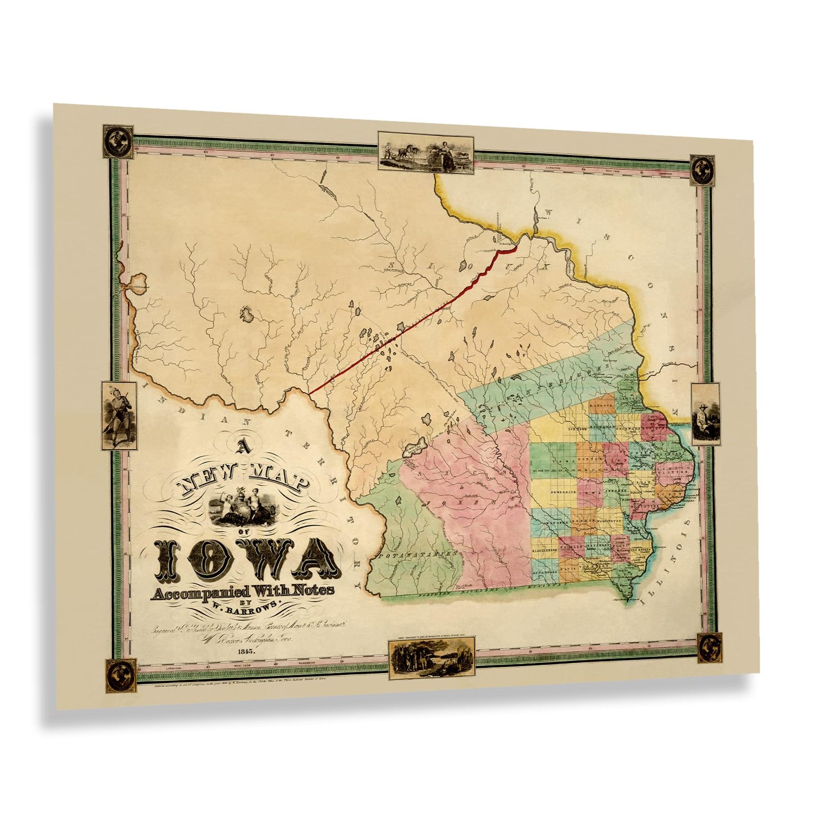
With its Eastern border located on the banks of the iconic Mississippi River, Iowa's proximity to the six states it borders allowed it to gain significant growth in the years following the completion of the Louisiana Purchase as scores of settlers arrived from French and Spanish Louisiana and established local communities based along cultural lines many of which exist to this day. At the time of this map's production, the United States had grown considerably. The Western frontiers were drawing immigrants for a variety of economic opportunities before the discovery of gold in the middle of the nineteenth century caused a large influx of prospectors, which led to the settlement of small towns en route to the Yukon and the Sierra Nevada mountains which provided these travelers with goods and created local economies which remained in place.
This map was produced the year before Iowa received statehood as the 29th state in the Union, allowing the area to settle boundary disputes and implement local government to help further bolster the economy, which was beginning to grow along with the rest of the region. The state has a long history of State Fairs and Harvest Festivals, which became synonymous with the American Dream of the nineteenth and early portions of the twentieth century.
This map bears a distinctive style and unique aesthetic that is immediately recognizable and transports the viewer back in time, creating a link between the past and present that illustrates the evolution of Iowa since its Territorial era.
Additional Details
------------------------------
Bullet point: VINTAGE MAP REPRODUCTION: You?ll love this high quality historic reproduction of 1845 Iowa Map Poster. Our museum quality prints are archival grade, which means it will look great and last without fading for over 100 years. Our print to order maps are made in the USA and each map is inspected for quality. This beautiful artwork is a perfect addition to your themed decor. Vintage maps look great in the home, study or office. They make a perfect gift as well.
Product description:
With its Eastern border located on the banks of the iconic Mississippi River, Iowa's proximity to the six states it borders allowed it to gain significant growth in the years following the completion of the Louisiana Purchase as scores of settlers arrived from French and Spanish Louisiana and established local communities based along cultural lines many of which exist to this day. At the time of this map's production, the United States had grown considerably. The Western frontiers were drawing immigrants for a variety of economic opportunities before the discovery of gold in the middle of the nineteenth century caused a large influx of prospectors, which led to the settlement of small towns en route to the Yukon and the Sierra Nevada mountains which provided these travelers with goods and created local economies which remained in place.
This map was produced the year before Iowa received statehood as the 29th state in the Union, allowing the area to settle boundary disputes and implement local government to help further bolster the economy, which was beginning to grow along with the rest of the region. The state has a long history of State Fairs and Harvest Festivals, which became synonymous with the American Dream of the nineteenth and early portions of the twentieth century.
This map bears a distinctive style and unique aesthetic that is immediately recognizable and transports the viewer back in time, creating a link between the past and present that illustrates the evolution of Iowa since its Territorial era.
Format: wall_map