HISTORIX Vintage 1818 Kentucky State Map - 13x25 Inch White Framed Vintage Map o
Shipping options
Seller handling time is 2 business days Details
This reflects the seller's handling time and may not include time spent in transit.
If you have questions about shipping, please contact the seller.
FREE via to United States
Return policy
Full refund available for DOAs
Details
- We guarantee our products and offer full refunds or exchange for defective items or items not as-described.
- Buyer must contact us within 30 days after receipt of shipment.
- The item must be received in the same condition as shipped.
- Items must be returned with all original packaging and accessories.
- Items must not be abused, modified or damaged by accident.
- A 20% restocking fee will be charged for returns
- Buyer is responsible for all return shipping and handling fees.
- Restocking and return shipping fees do not apply when item is returned as defective or because incorrect product was delivered.
Payment options
PayPal accepted
PayPal Credit accepted
Venmo accepted
PayPal, MasterCard, Visa, Discover, and American Express accepted
Maestro accepted
Amazon Pay accepted
Nuvei accepted
Item traits
| Category: |
Books & Magazines
|
| Quantity Available: |
8 in stock
|
| Condition: |
New
|
| ASIN: |
B09FL7NMPV
|
| EAN: |
0693634009343
|
| UPC: |
693634009343
|
| color: |
White
|
| Map Type: |
Travel
|
| Externally Assigned Product Identifier: |
0693634009343
|
| Bullet Point: |
View details
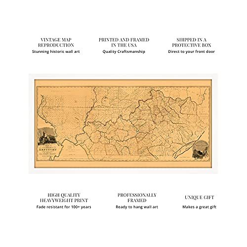
VINTAGE MAP FRAMED: You’ll love this high-quality white framed historic reproduction of 1818 Kentucky State Map. Our ready-to-hang maps are printed and framed in the USA by professional art framers using the highest quality materials. Each order i...
|
| Product Description: |
View details
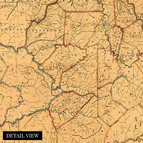
Published twenty-five years after Kentucky's inclusion to the United States as the fifteenth state, this map was produced by prolific Kentucky surveyor Luke Munsell. This detailed illustration shows the country in a time of growth though it rem...
|
| brand: |
HISTORIX
|
| Unspsc Code: |
55101500
|
| Paper Finish: |
matte
|
| Item Name: |
View details
HISTORIX Vintage 1818 Kentucky State Map - 13x25 Inch White Framed Vintage Map of Kentucky Poster - Historic Kentucky Map - Restored State Map of Kentucky Wall Art from Actual Survey
|
| Item Type Keyword: |
posters-&-prints
|
| Product Site Launch Date: |
2021-09-03T16:58:15.613Z
|
| size: |
13x25 Inch
|
Listing details
|
Seller policies:
|
View seller policies
|
|
Shipping discount:
|
Seller pays shipping for this item.
|
|
Posted for sale:
|
More than a week ago
|
|
Item number:
|
1735802389
|
Published twenty-five years after Kentucky's inclusion to the United States as the fifteenth state, this map was produced by prolific Kentucky surveyor Luke Munsell. This detailed illustration shows the country in a time of growth though it remained largely agrarian in the early 19th century. The state had been split from Virginia in its formation and became known for its rolling hills and Bourbon production. Bourbon, County Kentucky is the only location true Bourbon can be produced, and the state's robust corn cultivation spurred its distillation. Kentucky also relied on tobacco farming to support its economy.
Kentucky's largest city Louisville was a major shipping port, and the interstate travel allowed the city to flourish as ships had to be unloaded before continuing downriver due to the cities proximity to the Falls of Ohio. Louisville was a major Union stronghold during the Civil War, and the state remained firmly in the Union during the conflict.
The state's capital Frankfort was established in 1786 and is home to one of the oldest distilleries in America, Buffalo Trace, which was built in 1792. The state's coal mining industry was emerging during this period and would become one of the primary drivers of Kentucky's economy for the next century. The fertile soil of the Bluegrass pastures also supported rich agricultural interests. The deep history and rich heritage of Kentucky have endured through present day, and this illustration's distinctive aesthetic allows the viewer to be transported back in time.
Our ready-to-hang wall art are printed and framed in the USA using the highest quality materials with professional craftsmanship. This beautiful artwork is a perfect addition to your themed decor. Historic prints look great in the home, study or office. They also make an unforgettable gift.
Additional Details
------------------------------
Bullet point: VINTAGE MAP FRAMED: You?ll love this high-quality white framed historic reproduction of 1818 Kentucky State Map. Our ready-to-hang maps are printed and framed in the USA by professional art framers using the highest quality materials. Each order is inspected for quality. This beautiful artwork is a perfect addition to your themed decor. Vintage maps look great in the home, study or office. They also make an unforgettable gift.
Product description:
Published twenty-five years after Kentucky's inclusion to the United States as the fifteenth state, this map was produced by prolific Kentucky surveyor Luke Munsell. This detailed illustration shows the country in a time of growth though it remained largely agrarian in the early 19th century. The state had been split from Virginia in its formation and became known for its rolling hills and Bourbon production. Bourbon, County Kentucky is the only location true Bourbon can be produced, and the state's robust corn cultivation spurred its distillation. Kentucky also relied on tobacco farming to support its economy.
Kentucky's largest city Louisville was a major shipping port, and the interstate travel allowed the city to flourish as ships had to be unloaded before continuing downriver due to the cities proximity to the Falls of Ohio. Louisville was a major Union stronghold during the Civil War, and the state remained firmly in the Union during the conflict.
The state's capital Frankfort was established in 1786 and is home to one of the oldest distilleries in America, Buffalo Trace, which was built in 1792. The state's coal mining industry was emerging during this period and would become one of the primary drivers of Kentucky's economy for the next century. The fertile soil of the Bluegrass pastures also supported rich agricultural interests. The deep history and rich heritage of Kentucky have endured through present day, and this illustration's distinctive aesthetic allows the viewer to be transported back in time.
Our ready-to-hang wall art are printed and framed in the USA using the highest quality materials with professional craftsmanship. This beautiful artwork is a perfect addition to your themed decor. Historic prints look great in the home, study or office. They also make an unforgettable gift.