HISTORIX Vintage 1804 Baltimore Map Print - 26x38 Inch Black Framed Vintage Balt
Shipping options
Seller handling time is 2 business days Details
This reflects the seller's handling time and may not include time spent in transit.
If you have questions about shipping, please contact the seller.
FREE via to United States
Return policy
Full refund available for DOAs
Details
- We guarantee our products and offer full refunds or exchange for defective items or items not as-described.
- Buyer must contact us within 30 days after receipt of shipment.
- The item must be received in the same condition as shipped.
- Items must be returned with all original packaging and accessories.
- Items must not be abused, modified or damaged by accident.
- A 20% restocking fee will be charged for returns
- Buyer is responsible for all return shipping and handling fees.
- Restocking and return shipping fees do not apply when item is returned as defective or because incorrect product was delivered.
Payment options
PayPal accepted
PayPal Credit accepted
Venmo accepted
PayPal, MasterCard, Visa, Discover, and American Express accepted
Maestro accepted
Amazon Pay accepted
Nuvei accepted
Item traits
| Category: |
Books & Magazines
|
| Quantity Available: |
8 in stock
|
| Condition: |
New
|
| ASIN: |
B09NCC6T56
|
| EAN: |
0737214977872
|
| UPC: |
737214977872
|
| color: |
Black Frame
|
| Externally Assigned Product Identifier: |
0737214977872
|
| Item Shape: |
Rectangular
|
| Bullet Point: |
View details
VINTAGE MAP FRAMED: You’ll love this high-quality black framed historic reproduction of 1804 Baltimore Map. Our ready-to-hang maps are printed and framed in the USA by professional art framers using the highest quality materials. Each order is ins...
|
| Product Description: |
View details
Produced by early American mapmakers Warner & Hanna, this rare depiction of Baltimore shows the City in a unique period in its rich history. By 1797 it was the largest American City in what was considered the South at the time, and its populati...
|
| brand: |
HISTORIX
|
| Unspsc Code: |
55101500
|
| Paper Finish: |
matte
|
| Item Name: |
View details
HISTORIX Vintage 1804 Baltimore Map Print - 26x38 Inch Black Framed Vintage Baltimore City Wall Art - Old Baltimore Maryland Map Poster
|
| Item Type Keyword: |
prints
|
| Product Site Launch Date: |
2021-12-09T15:23:53.218Z
|
| material: |
Paper
|
| size: |
26x38 Inch
|
| style: |
Vintage
|
Listing details
|
Seller policies:
|
View seller policies
|
|
Shipping discount:
|
Seller pays shipping for this item.
|
|
Posted for sale:
|
More than a week ago
|
|
Item number:
|
1735171833
|
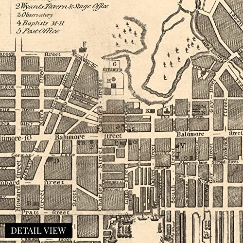
Produced by early American mapmakers Warner Hanna, this rare depiction of Baltimore shows the City in a unique period in its rich history. By 1797 it was the largest American City in what was considered the South at the time, and its population was continuing to expand by this map’s publication in 1804. Baltimore’s economy thrived during the latter portions of the eighteenth century, and it even grew during the Revolutionary War. The City had become one of the major drivers for the emerging United States. Its location allowed for significant trade in iron ore and other metal manufacturing from the North and agricultural products coming from the more rural South.
This unique city plan bears a distinctive aesthetic that immediately transports the viewer back in time and creates a link between present and past. It also illustrates the cities' immense growth and evolution in the subsequent centuries. During the Revolutionary War, Baltimore experienced no significant battles or military action, which contributed to its flourishing economy in America's early years. The City’s productive harbor was another essential factor in its prosperity. Additionally, advances made in the milling industry allowed Baltimore to dominate the international and domestic flour trade.
City planning and development were still being refined during the beginning of the eighteenth century, and this rare depiction of the process stands as a testament to Baltimore’s rich history. This is a genuine piece of American cartographical history and stands as a legacy to Baltimore's distinct local culture.
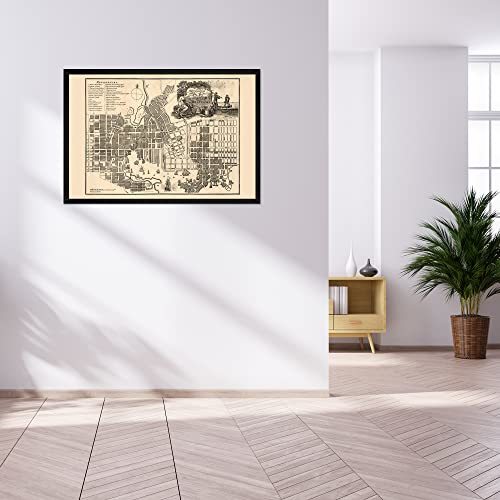
Our ready-to-hang wall art are printed and framed in the USA using the highest quality materials with professional craftsmanship. This beautiful artwork is a perfect addition to your themed decor. Historic prints look great in the home, study or office. They also make an unforgettable gift.
Additional Details
------------------------------
Bullet point: VINTAGE MAP FRAMED: You?ll love this high-quality black framed historic reproduction of 1804 Baltimore Map. Our ready-to-hang maps are printed and framed in the USA by professional art framers using the highest quality materials. Each order is inspected for quality. This beautiful artwork is a perfect addition to your themed decor. Vintage maps look great in the home, study or office. They also make an unforgettable gift.
Product description:
Produced by early American mapmakers Warner Hanna, this rare depiction of Baltimore shows the City in a unique period in its rich history. By 1797 it was the largest American City in what was considered the South at the time, and its population was continuing to expand by this map’s publication in 1804. Baltimore’s economy thrived during the latter portions of the eighteenth century, and it even grew during the Revolutionary War. The City had become one of the major drivers for the emerging United States. Its location allowed for significant trade in iron ore and other metal manufacturing from the North and agricultural products coming from the more rural South.
This unique city plan bears a distinctive aesthetic that immediately transports the viewer back in time and creates a link between present and past. It also illustrates the cities' immense growth and evolution in the subsequent centuries. During the Revolutionary War, Baltimore experienced no significant battles or military action, which contributed to its flourishing economy in America's early years. The City’s productive harbor was another essential factor in its prosperity. Additionally, advances made in the milling industry allowed Baltimore to dominate the international and domestic flour trade.
City planning and development were still being refined during the beginning of the eighteenth century, and this rare depiction of the process stands as a testament to Baltimore’s rich history. This is a genuine piece of American cartographical history and stands as a legacy to Baltimore's distinct local culture.
Our ready-to-hang wall art are printed and framed in the USA using the highest quality materials with professional craftsmanship. This beautiful artwork is a perfect addition to your themed decor. Historic prints look great in the home, study or office. They also make an unforgettable gift.