HISTORIX Vintage 1769 Map of Boston Massachusetts - 24x36 Inch Vintage Map Wall
Shipping options
Seller handling time is 2 business days Details
This reflects the seller's handling time and may not include time spent in transit.
If you have questions about shipping, please contact the seller.
FREE via to United States
Return policy
Full refund available for DOAs
Details
- We guarantee our products and offer full refunds or exchange for defective items or items not as-described.
- Buyer must contact us within 30 days after receipt of shipment.
- The item must be received in the same condition as shipped.
- Items must be returned with all original packaging and accessories.
- Items must not be abused, modified or damaged by accident.
- A 20% restocking fee will be charged for returns
- Buyer is responsible for all return shipping and handling fees.
- Restocking and return shipping fees do not apply when item is returned as defective or because incorrect product was delivered.
Payment options
PayPal accepted
PayPal Credit accepted
Venmo accepted
PayPal, MasterCard, Visa, Discover, and American Express accepted
Maestro accepted
Amazon Pay accepted
Nuvei accepted
Item traits
| Category: |
Kitchen Scales
|
| Quantity Available: |
8 in stock
|
| Condition: |
New
|
| Style: |
Vintage/Retro
|
| ASIN: |
B086VKRQ62
|
| binding: |
unknown_binding
|
| format: |
unknown_binding
|
| Map Type: |
Street
|
| Bullet Point: |
View details
VINTAGE MAP REPRODUCTION: You’ll love this high quality historic reproduction of 1769 Map of Boston Massachusetts. Our museum quality maps are archival grade, which means it will look great and last without fading for over 100 years. Our print to ...
|
| Product Description: |
View details
Published in 1769, this map of Boston was produced at a time of great tumult for the iconic American city. Though the Revolutionary war had yet to break out, tensions were high between the colonists and Great Britain. The passage of the Townsen...
|
| Brand: |
HISTORIX
|
| Unspsc Code: |
60121000
|
| Item Type Keyword: |
prints
|
| size: |
24x36 Inch
|
| Paper Size: |
24 x 36
|
| manufacturer: |
Historix
|
| Item Shape: |
Square
|
| Paper Finish: |
matte
|
| Item Name: |
View details
HISTORIX Vintage 1769 Map of Boston Massachusetts - 24x36 Inch Vintage Map Wall Art - Vintage Boston Map Art Showing Buildings and Streets in 1769 - Boston Map Wall Art - Boston Map Poster
|
| Product Site Launch Date: |
2020-04-07T12:48:31.814Z
|
| Material: |
Paper
|
Listing details
|
Seller policies:
|
View seller policies
|
|
Shipping discount:
|
Seller pays shipping for this item.
|
|
Posted for sale:
|
More than a week ago
|
|
Item number:
|
1735787370
|
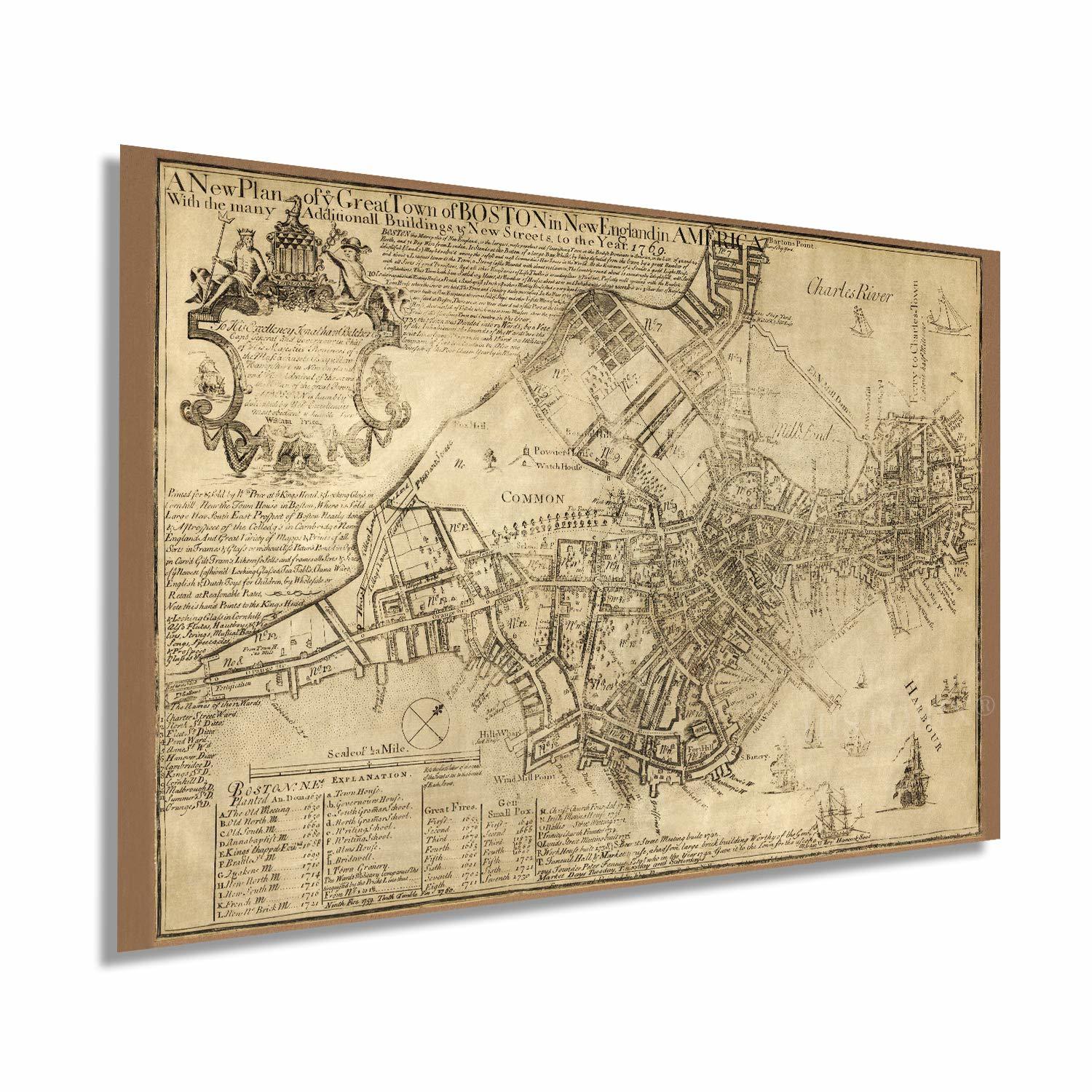
Published in 1769, this map of Boston was produced at a time of great tumult for the iconic American city. Though the Revolutionary war had yet to break out, tensions were high between the colonists and Great Britain. The passage of the Townsend Acts in 1767 had further angered colonists, and Boston was a hotbed for patriot speech and action. Boston’s role in the Revolution was crucial, and this depiction in 1769 paints a unique picture of the city in a time of transition and just one year before the famous Boston Massacre. British troops that had been stationed in the city since 1868 opened fire on a group of pro-independence protestors, and the incident served as fuel for the growing Patriotic movement.
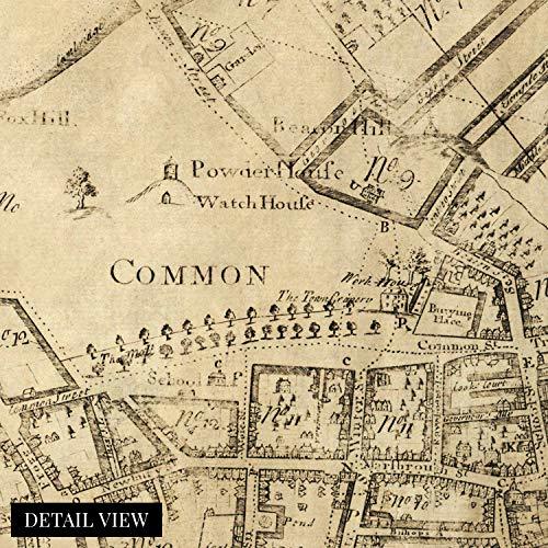
Some of the interesting features of this illustration include the details regarding the dates of significant fires as well as outbreaks of smallpox. It also features landmarks that have been filled and re-purposed like Mill Pond as well as prominent features that remain to this day like Boston Common.
William Price, the producer of this map, owned the rights to this map, which was initially printed in 1726. Price would amend and update the map re-printing for the following forty years. Street names were added or changed, and new buildings were depicted by shading rather than perspective drawing. The details, additions, and cartouche make this map the best visual record of pre-Revolutionary Boston and an authentic piece of both American and cartographical history.
Our museum quality giclee print comes printed with archival ink on premium heavyweight matte paper. Shipped in a sturdy cardboard tube your print will arrive ready to be framed. This eye-catching vintage map print makes the perfect gift for anyone that loves history and imagery.
Additional Details
------------------------------
Bullet point: VINTAGE MAP REPRODUCTION: You?ll love this high quality historic reproduction of 1769 Map of Boston Massachusetts. Our museum quality maps are archival grade, which means it will look great and last without fading for over 100 years. Our print to order maps are made in the USA and each map is inspected for quality. This beautiful artwork is a perfect addition to your themed decor. Vintage maps look great in the home, study or office. They make a perfect gift as well.
Product description:
Published in 1769, this map of Boston was produced at a time of great tumult for the iconic American city. Though the Revolutionary war had yet to break out, tensions were high between the colonists and Great Britain. The passage of the Townsend Acts in 1767 had further angered colonists, and Boston was a hotbed for patriot speech and action. Boston’s role in the Revolution was crucial, and this depiction in 1769 paints a unique picture of the city in a time of transition and just one year before the famous Boston Massacre. British troops that had been stationed in the city since 1868 opened fire on a group of pro-independence protestors, and the incident served as fuel for the growing Patriotic movement.
Some of the interesting features of this illustration include the details regarding the dates of significant fires as well as outbreaks of smallpox. It also features landmarks that have been filled and re-purposed like Mill Pond as well as prominent features that remain to this day like Boston Common.
William Price, the producer of this map, owned the rights to this map, which was initially printed in 1726. Price would amend and update the map re-printing for the following forty years. Street names were added or changed, and new buildings were depicted by shading rather than perspective drawing. The details, additions, and cartouche make this map the best visual record of pre-Revolutionary Boston and an authentic piece of both American and cartographical history.
Our museum quality giclee print comes printed with archival ink on premium heavyweight matte paper. Shipped in a sturdy cardboard tube your print will arrive ready to be framed. This eye-catching vintage map print makes the perfect gift for anyone that loves history and imagery.
Style: Vintage