Rendered at 08:49:25 08/14/25


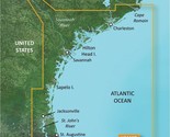
GARMIN BLUECHART® G3 VISION® HD -VUS008R-CHARLESTON TO JACKSONVILLE MICROSD/SD
$319.00

Shipping options
Estimated to arrive by Wed, Aug 20th.
Details
$3.95 via UPS Ground (1 to 5 business days) to United States
Return policy
Full refund available within 30 days
Purchase protection
Catalog info
Payment options
PayPal accepted
PayPal Credit accepted
Venmo accepted
PayPal, MasterCard, Visa, Discover, and American Express accepted
Maestro accepted
Amazon Pay accepted
Nuvei accepted
Item traits
| Category: | |
|---|---|
| Quantity Available: |
Only one in stock, order soon |
| Condition: |
New |
| Brand: |
Garmin |
| Model: |
30362 |
| MPN: |
010-C0709-00 |
| Sport/Activity: |
Fishing |
| Indoor/Outdoor: |
Outdoor |
| Type: |
Premier Coastal Navigation Charts |
| Manufacturer Warranty: |
Please contact the manufacturer directly with any issues or conce |
| Features: | |
| UPC: |
753759068899 |
Listing details
| Seller policies: | |
|---|---|
| Shipping discount: |
Items after first shipped at flat $4.00 |
| Posted for sale: |
More than a week ago |
| Item number: |
1516874806 |
Item description
GVO Marine Electronics:
We provide reliable, safe online shopping 24 hours a day, 7 days a week throughout the U.S. and the world. We are strongly committed to providing our customers with top quality merchandise and world class service.
Model 30362
BlueChart g3 Vision HD - VUS008R - Charleston to Jacksonville - microSD?/SD?
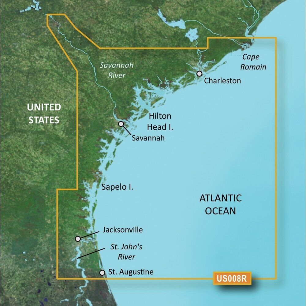
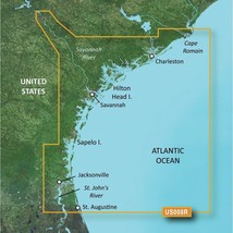
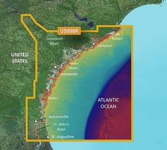
Coverage:
Cape Romain through St. Augustine including Charleston, Savannah and Jacksonville with the St. John's River covered to the Clay County line.
Premier Coastal Navigation Charts
Provides industry-leading coverage, clarity and detail with updated coastal charts that feature integrated Garmin and Navionics data
Auto Guidance technology uses your desired depth and overhead clearance to calculate routes and show a suggested path to follow
High-resolution relief shading combines color and shadow to give you an easy-to-interpret, clearer view of bottom structure than contour lines alone
Depth Range Shading provides up to 10 depth ranges, enabling you to view your target depth at a glance
Up to 1? contours provide a more accurate depiction of the bottom structure for improved fishing charts and navigation in swamps, canals and marinas
Experience unparalleled coverage and brilliant detail on the water. BlueChart g3 Vision coastal charts provide industry-leading coverage, clarity and detail with integrated Garmin and Navionics data, Auto Guidance technology and high-resolution relief shading..
Auto Guidance Technology
The Auto Guidance feature uses your desired depth and overhead clearance to calculate a route and a suggested path to follow.
High-resolution Relief Shading Feature
High-resolution relief shading combines color and shadow to give you an easy-to-interpret, clearer view of bottom structure than contour lines alone.
Up to 1? Contours
The closer the contour lines, the more accurate the depiction of the bottom structure for improved fishing charts and navigation in swamps, canals and marinas.
NOAA Raster Cartography
If you prefer your display to have the look of paper charts, NOAA raster cartography2 is available as a free downloadable feature via the ActiveCaptain app.
Depth Range Shading
This feature provides up to 10 depth ranges, enabling you to view your target depth at a glance.
Shallow Water Shading
This feature allows you to use shading to designate the shallow water depths you need to avoid.
High-resolution Satellite Imagery
These detailed images of ports, marinas, bridges and navigational landmarks help provide you with superior situational awareness.
Unique 3-D Views
MarinerEye and FishEye views provide additional perspective both above and below the water line.
Auto Guidance is for planning purposes only and does not replace safe navigation operations
Raster cartography cannot be viewed on echoMAP CHIRP and ECHOMAP Plus combos but can be viewed on mobile devices via the ActiveCaptain mobile app
*THIS ITEM CAN NOT BE RETRUNED TO THE ORIGINAL POINT OF PURCHAS. PLEASE CONTACT GARMIN DIRECTLY WITH ANY ISSUES OR CONCERNS.
GVO Marine Electronics: .
Get the item you ordered or get your money back.
Covers your purchase price and original shipping.
Added to your wish list!
- GARMIN BLUECHART® G3 VISION® HD -VUS008R-CHARLESTON TO JACKSONVILLE MICROSD/SD
- 1 in stock
- Handling time 1 day. Estimated delivery: Wed, Aug 20th
- Returns/refunds accepted
Get an item reminder
We'll email you a link to your item now and follow up with a single reminder (if you'd like one). That's it! No spam, no hassle.
Already have an account?
Log in and add this item to your wish list.