2004 Dominican Republic Map Poster - Dominican Republic Wall Art Decor Print
Shipping options
Seller handling time is 2 business days Details
This reflects the seller's handling time and may not include time spent in transit.
If you have questions about shipping, please contact the seller.
FREE in United States
Return policy
Full refund available for DOAs
Details
- We guarantee our products and offer full refunds or exchange for defective items or items not as-described.
- Buyer must contact us within 30 days after receipt of shipment.
- The item must be received in the same condition as shipped.
- Items must be returned with all original packaging and accessories.
- Items must not be abused, modified or damaged by accident.
- A 20% restocking fee will be charged for returns
- Buyer is responsible for all return shipping and handling fees.
- Restocking and return shipping fees do not apply when item is returned as defective or because incorrect product was delivered.
Payment options
PayPal accepted
PayPal Credit accepted
Venmo accepted
PayPal, MasterCard, Visa, Discover, and American Express accepted
Maestro accepted
Amazon Pay accepted
Nuvei accepted
Item traits
| Category: |
Art Prints
|
| Quantity Available: |
16 in stock
|
| Condition: |
New
|
| Subject: |
Maps
|
| Style: |
Vintage
|
| Type: |
Wall Art
|
| Features: |
Museum Quality
|
| Theme: |
History
|
| Artist: |
Various
|
| Region of Origin: |
Made in the USA
|
| Framing: |
Unframed
|
| Brand: |
HISTORIX
|
| Sizes: |
View details
18 x 24 Inch (8 in stock)
24 x 36 Inch (8 in stock)
|
Listing details
|
Seller policies:
|
View seller policies
|
|
Shipping discount:
|
Seller pays shipping for this item.
|
|
Posted for sale:
|
More than a week ago
|
|
Item number:
|
1738798017
|
Feature Points
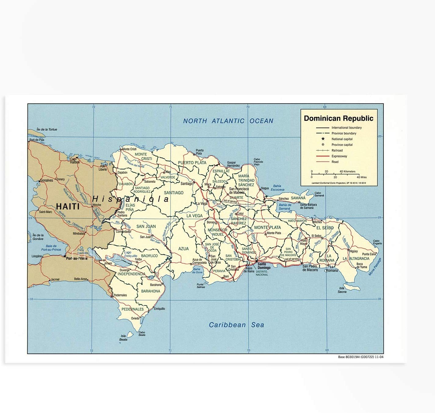
VINTAGE MAP REPRODUCTION: You?ll love this high quality historic reproduction of 2004 Dominican Republic Map Poster. Our museum quality maps are archival grade, which means it will look great and last without fading for over 100 years. Our print to order maps are made in the USA and each map is inspected for quality. This beautiful artwork is a perfect addition to your themed decor. Vintage maps look great in the home, study or office. They make a perfect gift as well.
MUSEUM QUALITY: This high quality map print will be a great addition to your vintage-themed wall. Don't waste money on cheap-looking, thin paper posters. We use thick, fine art print quality matte paper. Our professional?s choice matte paper displays artwork in high detail without glare. The color is vibrant and the text is easy to read. When framed, this map looks absolutely stunning.
A LOOK BACK AT HISTORY: This is an impressive, historic reproduction of 2004 Dominican Republic Map Poster. This print is from an original found in the maps and geography division of the US Library of Congress. A true piece of history. See our product description section for more fascinating information about this historic map and its significance.
READY TO FRAME: This print includes a 0.2 inch border for a perfect frame fit and look. Our maps are designed to fit easy-to-find standard frame sizes, saving you money from having to pay for a custom frame. Each map is inspected for quality and shipped in a rigid tube.
HISTORIX: We love history and art. Sometimes old maps have tears, folds, separations and other blemishes. We digitally restore and enhance maps while keeping its historical character. All our maps are proudly made in the USA. Customers all over the world love our vintage maps and we know you will too.
Additional Information
Published in the same year as the re-election victory for President Leonel Fernandez and the historic floods, which were the result of two weeks of heavy rainfall over the island nation. The Dominican Republic shares a border with Haiti on the larger Caribbean Island of Hispaniola and has a rich history since Columbus? landing in 1492. The first settlement in the so-called New World was in the Dominican Republic with Columbus? brother?s establishment of Santo Domingo. Santo Domingo became the springboard for the Spanish exploration of the Americas while the island itself saw a boom in mining after the discovery of gold.
The Dominican Republic holds the ninth-largest economy in Latin America and is the largest economy in the Caribbean Island region. The CIA started producing maps in 1941, and the distinctive aesthetic is consistent for their productions across the globe. The geo-political information and boundaries presented by these maps are utilized by American Intelligence organizations to analyze geodata for maximum understanding of different global regions.
This depiction was created in 2004 before the CIA shifted its cartographical concerns towards digitized publications and stands as a testament to the rich history of CIA mapmaking. The period from 2000 to 2010 was the last of CIA producing maps for print, making this an authentic piece of American cartographical history. During this time, the Dominican Republic was working towards greater economic prosperity and development while maintaining its status in the Caribbean and exporting a rich culture and history.
Our museum quality giclee print comes printed with archival ink on premium heavyweight matte paper. Shipped in a sturdy cardboard tube your print will arrive ready to be framed. This eye-catching map reproduction print makes the perfect gift for anyone that loves history and imagery.