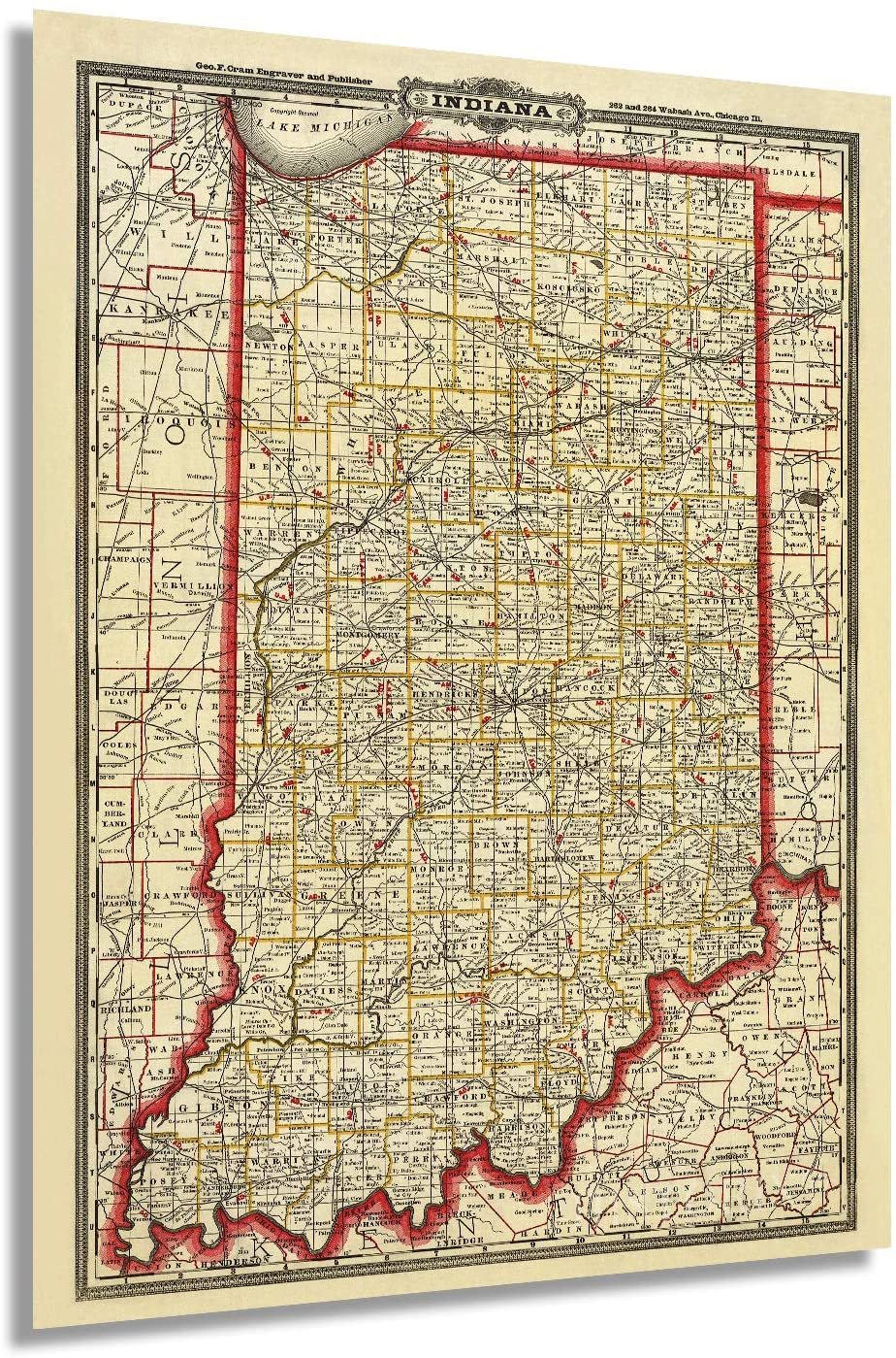
1888 Indiana State Map - Vintage State of Indiana Wall Art Decor Poster Print
Shipping options
Seller handling time is 2 business days Details
This reflects the seller's handling time and may not include time spent in transit.
If you have questions about shipping, please contact the seller.
FREE in United States
Return policy
Full refund available for DOAs
Details
- We guarantee our products and offer full refunds or exchange for defective items or items not as-described.
- Buyer must contact us within 30 days after receipt of shipment.
- The item must be received in the same condition as shipped.
- Items must be returned with all original packaging and accessories.
- Items must not be abused, modified or damaged by accident.
- A 20% restocking fee will be charged for returns
- Buyer is responsible for all return shipping and handling fees.
- Restocking and return shipping fees do not apply when item is returned as defective or because incorrect product was delivered.
Payment options
PayPal accepted
PayPal Credit accepted
Venmo accepted
PayPal, MasterCard, Visa, Discover, and American Express accepted
Maestro accepted
Amazon Pay accepted
Nuvei accepted
Item traits
| Category: |
Art Prints
|
| Quantity Available: |
16 in stock
|
| Condition: |
New
|
| Subject: |
Maps
|
| Style: |
Vintage
|
| Type: |
Wall Art
|
| Features: |
Museum Quality
|
| Theme: |
History
|
| Artist: |
Various
|
| Region of Origin: |
Made in the USA
|
| Framing: |
Unframed
|
| Brand: |
HISTORIX
|
| Sizes: |
View details
18 x 24 Inch (8 in stock)
24 x 36 Inch (8 in stock)
|
Listing details
|
Seller policies:
|
View seller policies
|
|
Shipping discount:
|
Seller pays shipping for this item.
|
|
Posted for sale:
|
More than a week ago
|
|
Item number:
|
1738798138
|
Feature Points
VINTAGE MAP REPRODUCTION: You?ll love this high quality historic reproduction of 1888 Indiana State Map. Our museum quality maps are archival grade, which means it will look great and last without fading for over 100 years. Our print to order maps are made in the USA and each map is inspected for quality. This beautiful artwork is a perfect addition to your themed decor. Vintage maps look great in the home, study or office. They make a perfect gift as well.
MUSEUM QUALITY: This high quality map print will be a great addition to your vintage-themed wall. Don't waste money on cheap-looking, thin paper posters. We use thick, fine art print quality matte paper. Our professional?s choice matte paper displays artwork in high detail without glare. The color is vibrant and text is easy to read. When framed, this map looks absolutely stunning.
A LOOK BACK AT HISTORY: This is an impressive, historic reproduction of 1888 Indiana State Map. This print is from an original found in the maps and geography division of the US Library of Congress. A true piece of history. See our product description section for more fascinating information about this historic map and its significance.
READY TO FRAME: This print includes a 0.2 inch border for a perfect frame fit and look. Our maps are designed to fit easy-to-find standard frame sizes, saving you money from having to pay for a custom frame. Each map is inspected for quality and shipped in a rigid tube.
HISTORIX: We love history and art. Sometimes old maps have tears, folds, separations and other blemishes. We digitally restore and enhance maps while keeping its historical character. All our maps are proudly made in the USA. Customers all over the world love our vintage maps and we know you will too.
Additional Information
Initially published in 1888, this Railway map was produced by one of the most well-known 19th-century map makers George Cram. Cram?s company went on to become the first American company to release a World Atlas in 1901. This incredibly detailed illustration provided a wealth of information for merchants and residents alike and is a unique link to life as an American in the mid-1800s.
Before the Railway system was completed in 1865, the Mississippi River was the primary form of transit for exporting goods out of Indiana via the Wabash and Ohio River. The Railways became necessary for the northern regions of Indiana, especially in the 1880s, when a natural gas boom transformed the economy and spurred massive growth and population expansions. At the time, the Indiana Gas Field was the largest in the world. By allowing east-west transport, the Railways were Indiana?s connection to the rest of the nation, and the links permitted the state economy to thrive.
The rails carried a romance of the time, and in the mid-1850s, Indiana was rapidly building tracks with young men enamored with a life outside of the agrarian establishment. Indianapolis became known as ?The City of Railroads,? with seven railroads converging in the city. Following the conclusion of the Civil War, the rail line became a useful tool for passengers as well as freight and interurban travel. This map was published the same year as the completion of the new Union Station in Indianapolis.
Our museum quality Indiana Map Art comes printed with archival ink on premium heavyweight matte paper. Shipped in a sturdy cardboard tube your Indiana Poster will arrive ready to be framed. This eye-catching print makes the perfect gift for anyone that loves history and imagery.