1887 Indian Territory Oklahoma Map - Indian Terrirtory Wall Art Poster Print
Shipping options
Seller handling time is 2 business days Details
This reflects the seller's handling time and may not include time spent in transit.
If you have questions about shipping, please contact the seller.
FREE in United States
Return policy
Full refund available for DOAs
Details
- We guarantee our products and offer full refunds or exchange for defective items or items not as-described.
- Buyer must contact us within 30 days after receipt of shipment.
- The item must be received in the same condition as shipped.
- Items must be returned with all original packaging and accessories.
- Items must not be abused, modified or damaged by accident.
- A 20% restocking fee will be charged for returns
- Buyer is responsible for all return shipping and handling fees.
- Restocking and return shipping fees do not apply when item is returned as defective or because incorrect product was delivered.
Payment options
PayPal accepted
PayPal Credit accepted
Venmo accepted
PayPal, MasterCard, Visa, Discover, and American Express accepted
Maestro accepted
Amazon Pay accepted
Nuvei accepted
Item traits
| Category: |
Art Prints
|
| Quantity Available: |
16 in stock
|
| Condition: |
New
|
| Subject: |
Maps
|
| Style: |
Vintage
|
| Type: |
Wall Art
|
| Features: |
Museum Quality
|
| Theme: |
History
|
| Artist: |
Various
|
| Region of Origin: |
Made in the USA
|
| Framing: |
Unframed
|
| Brand: |
HISTORIX
|
| Sizes: |
View details
18 x 24 Inch (8 in stock)
24 x 36 Inch (8 in stock)
|
Listing details
|
Seller policies:
|
View seller policies
|
|
Shipping discount:
|
Seller pays shipping for this item.
|
|
Posted for sale:
|
More than a week ago
|
|
Item number:
|
1738798128
|
Feature Points
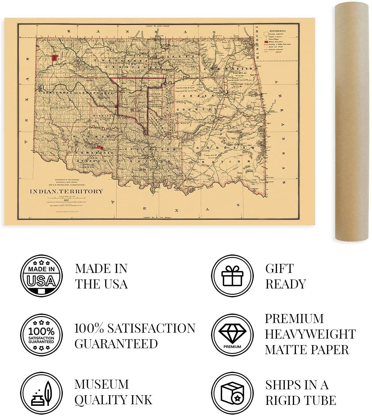
VINTAGE MAP REPRODUCTION: You?ll love this high quality historic reproduction of 1887 Indian Territory Oklahoma Map. Our museum quality maps are archival grade, which means it will look great and last without fading for over 100 years. Our print to order maps are made in the USA and each map is inspected for quality. This beautiful artwork is a perfect addition to your themed decor. Vintage maps look great in the home, study or office. They make a perfect gift as well.
MUSEUM QUALITY: This high quality map print will be a great addition to your vintage-themed wall. Don't waste money on cheap-looking, thin paper posters. We use thick, fine art print quality matte paper. Our professional?s choice matte paper displays artwork in high detail without glare. The color is vibrant and text is easy to read. When framed, this map looks absolutely stunning.
A LOOK BACK AT HISTORY: This is an impressive, historic reproduction of 1887 Indian Territory Oklahoma Map. This print is from an original found in the maps and geography division of the US Library of Congress. A true piece of history. See our product description section for more fascinating information about this historic map and its significance.
READY TO FRAME: This print includes a 0.2 inch border for a perfect frame fit and look. Our maps are designed to fit easy-to-find standard frame sizes, saving you money from having to pay for a custom frame. Each map is inspected for quality and shipped in a rigid tube.
HISTORIX: We love history and art. Sometimes old maps have tears, folds, separations and other blemishes. We digitally restore and enhance maps while keeping its historical character. All our maps are proudly made in the USA. Customers all over the world love our vintage maps and we know you will too.
Additional Information
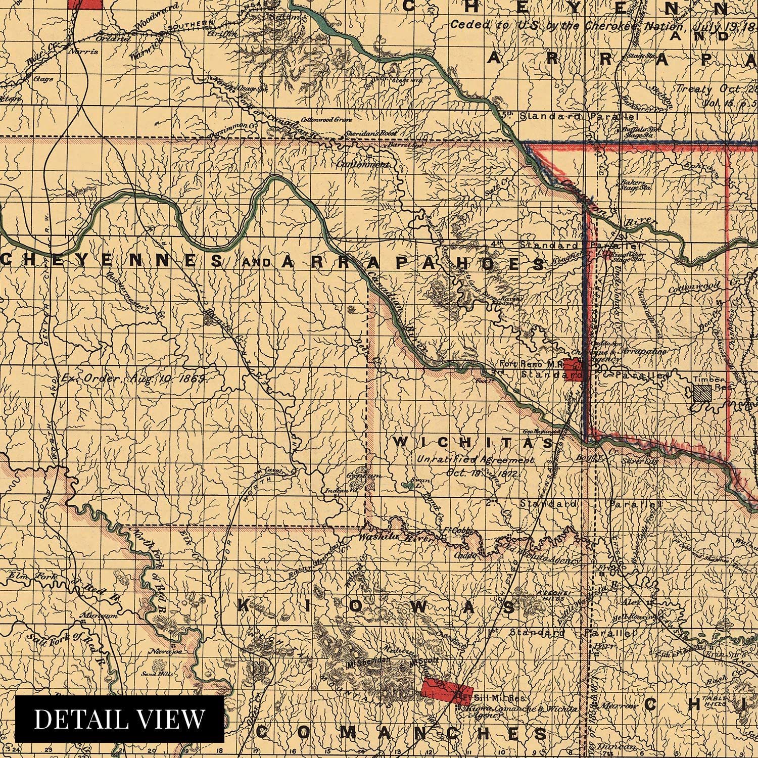
By 1887 Indian territory shared what would become the state boundaries for present-day Oklahoma. Its primary residents were comprised of the Cherokee, Choctaw, Muscogee, Chickasaw, and Seminole tribes, and this map shows land divisions across tribal lines. It also illustrates the boundaries and formation of the Oklahoma Territory with the Indian Territory.
Published three years before the official incorporation as a territory of the United States, this map contains extensive details that relate to the tribal composition of the area, including dates and locations of treaties. It has also been annotated to illustrate the division of the Oklahoma Territory from the Indian Territory.
The viewer also gets a sense of the natural topography of the lands gentle slope from high plains in the west to low wetlands in the southeast. It is one of the most ecologically diverse states in the nation with 11 distinct ecological regions, and homes to the only mountain range found between the Appalachians in the East and the Rockies in the west. Cavanal Hill, near Poteau, is considered the world's tallest hill at one foot short of the 2000 ft standard for a mountain. The Cherokee Nation Courthouse, built-in 1849, is preserved as a historical site and is the oldest standing building in Oklahoma.
The distinctive aesthetic of this map brings to life a time of American History when frontiers were being civilized, and modern America began to take shape. Oklahoma was on the verge of one of the most massive oil booms in History at this time.
Our museum quality giclee print comes printed with archival ink on premium heavyweight matte paper. Shipped in a sturdy cardboard tube your print will arrive ready to be framed. This eye-catching vintage map print makes the perfect gift for anyone that loves history and imagery.