1864 Richmond Virginia Map Poster - Vintage City of Richmond VA Wall Art Print
Shipping options
Seller handling time is 2 business days Details
This reflects the seller's handling time and may not include time spent in transit.
If you have questions about shipping, please contact the seller.
FREE in United States
Return policy
Full refund available for DOAs
Details
- We guarantee our products and offer full refunds or exchange for defective items or items not as-described.
- Buyer must contact us within 30 days after receipt of shipment.
- The item must be received in the same condition as shipped.
- Items must be returned with all original packaging and accessories.
- Items must not be abused, modified or damaged by accident.
- A 20% restocking fee will be charged for returns
- Buyer is responsible for all return shipping and handling fees.
- Restocking and return shipping fees do not apply when item is returned as defective or because incorrect product was delivered.
Payment options
PayPal accepted
PayPal Credit accepted
Venmo accepted
PayPal, MasterCard, Visa, Discover, and American Express accepted
Maestro accepted
Amazon Pay accepted
Nuvei accepted
Item traits
| Category: |
Art Prints
|
| Quantity Available: |
16 in stock
|
| Condition: |
New
|
| Subject: |
Maps
|
| Style: |
Vintage
|
| Type: |
Wall Art
|
| Features: |
Museum Quality
|
| Theme: |
Vintage
|
| Artist: |
Various
|
| Region of Origin: |
Made in the USA
|
| Brand: |
HISTORIX
|
| Sizes: |
View details
18x24 Inch (8 in stock)
24x30 Inch (8 in stock)
|
Listing details
|
Seller policies:
|
View seller policies
|
|
Shipping discount:
|
Seller pays shipping for this item.
|
|
Posted for sale:
|
More than a week ago
|
|
Item number:
|
1738798317
|
HISTORIX Vintage 1864 Richmond Virginia Map - Vintage Richmond Map Wall Art - Historic Map of Richmond VA Poster - Old Richmond Map - City of Richmond VA Map Print
Features
VINTAGE MAP REPRODUCTION: You'll love this high quality historic reproduction of 1864 Richmond Map. Our museum quality maps are archival grade, which means it will look great and last without fading for over 100 years. Our print to order maps are made in the USA and each map is inspected for quality. This beautiful artwork is a perfect addition to your themed decor. Vintage maps look great in the home, study or office. They make a perfect gift as well.
MUSEUM QUALITY: This high quality map print will be a great addition to your vintage-themed wall. Don't waste money on cheap-looking, thin paper posters. We use thick, fine art print quality matte paper. Our professional's choice matte paper displays artwork in high detail without glare. The color is vibrant and the text is easy to read. When framed, this map looks absolutely stunning.
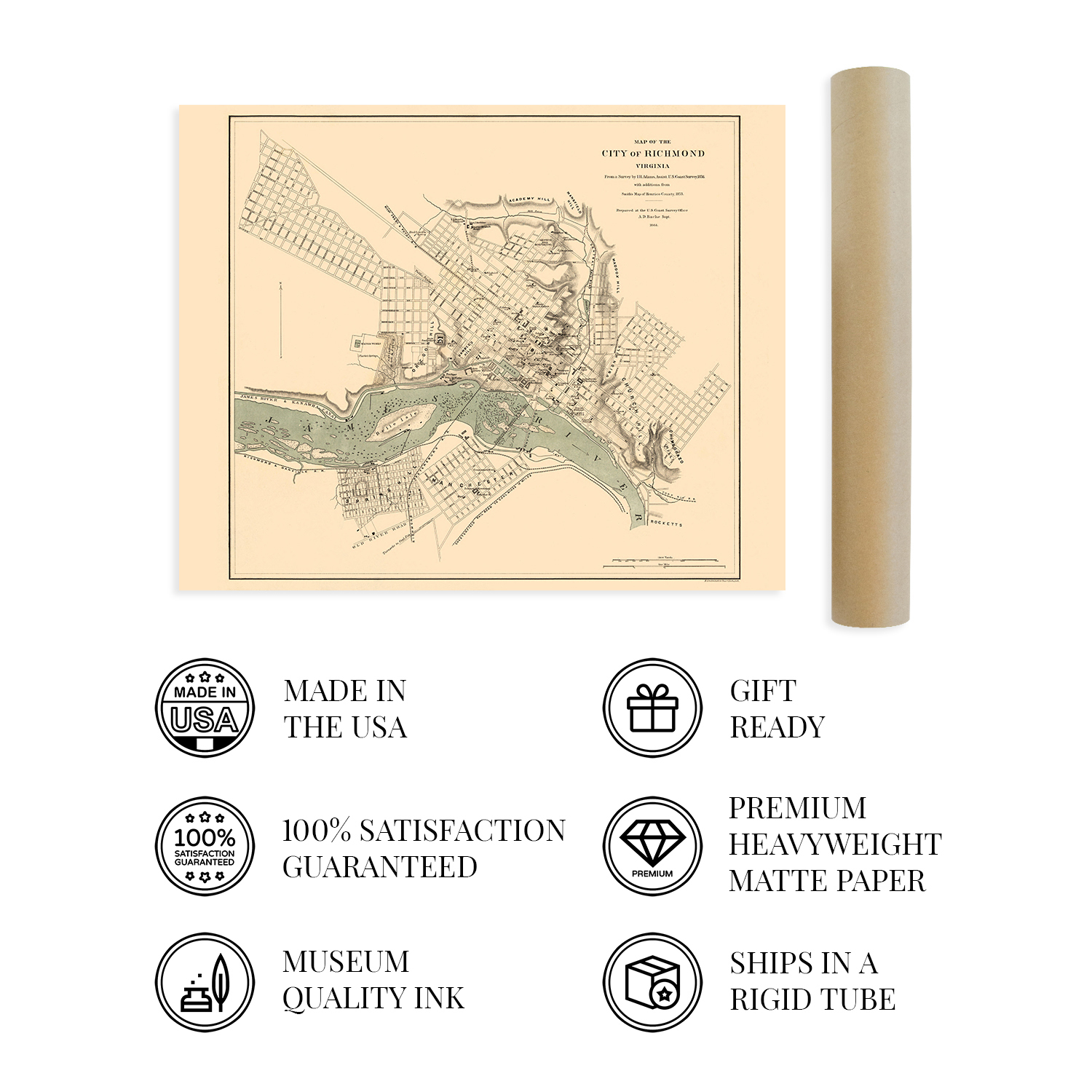
A LOOK BACK AT HISTORY: This is an impressive, historic reproduction of 1864 Richmond Virginia Map. This print is from an original found in the maps and geography division of the US Library of Congress. A true piece of history. See our product description section for more fascinating information about this historic map and its significance.
READY TO FRAME: This print includes a 0.2 inch border for a perfect frame fit and look. Our maps are designed to fit easy-to-find standard frame sizes, saving you money from having to pay for a custom frame. Each map is inspected for quality and shipped in a rigid tube.
HISTORIX: We love history and art. Sometimes old maps have tears, folds, separations and other blemishes. We digitally restore and enhance maps while keeping its historical character. All our maps are proudly made in the USA. Customers all over the world love our vintage maps and we know you will too.
Additional Information
Published one year before the conclusion of the American Civil War, this unique depiction of the State Capital of Virginia shows it in a tumultuous period as the Capital of the Confederacy under siege by Union Forces. Produced by the United States Coast Survey, this would have been a critical tool for Union Generals looking to break the Confederate stronghold and regain control of the Southern States. The iconic American cities' location on the James River provided thriving mill and manufacturing industries that attracted immigrants from Western Europe, Ireland, and England. These immigrant communities established thriving neighborhoods along cultural lines, many of which exist to this day.
As the terminus of five railroads, Richmond had become a critical transportation hub providing access to the Chesapeake Bay and the Atlantic Ocean. The city was incorporated in 1742 and is one of the oldest in the nation. Its rich history and status as a cultural center in the South cannot be underestimated, and Richmond has maintained a rich history since its foundation. Richmond would again become an important manufacturing and milling center in the years following the end of the Civil War. By 1850 some 200 tons of cargo flowed through the city north to Baltimore and Philadelphia.
This detailed illustration immediately transports the viewer back in time and creates an indelible link between the past and present. The US Coast Survey was a critical resource for military campaigns throughout the Civil War, and this is an authentic piece of American cartographical history.
Our museum quality giclee print comes printed with archival ink on premium heavyweight matte paper. Shipped in a sturdy cardboard tube your print will arrive ready to be framed. This eye-catching vintage map reproduction print makes the perfect gift for anyone that loves history and imagery.