Rendered at 01:16:06 05/30/25


1778 Antonio Zatta Colonial America Virginia North Caroline Cherokee Harrods COA

Shipping options
Offer policy
OBO - Seller accepts offers on this item.
Details
Return policy
Full refund available within 30 days
Purchase protection
Payment options
PayPal accepted
PayPal Credit accepted
Venmo accepted
PayPal, MasterCard, Visa, Discover, and American Express accepted
Maestro accepted
Amazon Pay accepted
Nuvei accepted
Item traits
| Category: | |
|---|---|
| Quantity Available: |
Only one in stock, order soon |
| Condition: |
Unspecified by seller, may be new. |
| Type: |
Geological Map |
| Original/Reproduction: |
Antique Original |
| Date Range: |
1700-1799 |
| Year: |
1778 |
| Country/Region: |
United States of America |
| US State: |
North Carolina |
| Format: |
Sheet Map |
| Cartographer/Publisher: |
Antonio Zatta |
Listing details
| Seller policies: | |
|---|---|
| Shipping discount: |
Shipping weights of all items added together for savings. | Free shipping on orders over $300.00 |
| Price discount: |
10% off w/ $200.00 spent |
| Posted for sale: |
More than a week ago |
| Item number: |
1707694810 |
Item description
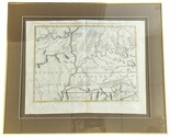
1778 Antonio Zatta Colonial America Virginia North Caroline Cherokee Regions, plus a 1979 Harrods Certificate of Authenticity. Italian text. Hand colored. Antique original, custom framed, double matted.
Actual map measures about 16 x 13".
Framed and matted artwork measures 25" x 21".
Framed Certificate from Harrod's measures 9-1/2" by 11-1/2".
Certificate signed and dated 1979 from Harrods Collectors Treasures Ltd, Harrods Department Store, England, Antique Maps and Print Decorative Art, Hogarth House High Street Wendover, Bucks HP22 6 DU England and Harrods Ltd. Knightsbridge London SW1. Signed by Keith H. Oliver on 11/8/79.
Official Title:
Il Paese de Cherachesi, con la Parte Occidentale della Carolina Settentriondale e Della Virginia.
1778 Zatta Map of Southern States - Virginia, Carolinas, Kentucky, Tennessee Region.
Map Maker: Antonio Zatta
Hand Colored
Publication Date: 1778
Publication Place: Venice, Italy
Mapmaker Antonio Zatta was a Venetian map publisher known for his late 18th and early 19th century maps. He published maps of North and South America, including the four volume Atlante Novissima published from 1775 to 1789. That work incorporated the latest travel accounts and exploration, including the first representation of the new islands explored by Captain Cook in an Italian atlas.
This map pre-dates the American Revolution and shows an area including what is now Virginia, the Carolinas, Kentucky and Tennessee. Some of the areas are designated with the name of the original indigenous peoples that still lived in those areas the Cherakesi (Cherokee), the Chicachesi (Chickasaw), the Mohican, and the Shawnees plus others. Territory west of the Mississippi was labeled Spanish Louisiana.
The map is of part of twelve sheets that joined to form Antonio Zatta's version of John Mitchell's 1755 landmark map of North America, published first in 1778. This is for the single framed sheet pictured (the entire 12 sheet joined map is quite rare and expensive.) Zatta is one of the mapmakers credited with the 18th eighteenth-century revival of fine printing in Italy. In January of 1971, the Metropolitan Museum of Art Bulletin, New Series, Vol. 29, No. 5, described Zatta's printing and design as harmonious in composition with ornament unified by style, quality of line, and tone of printing.
Condition: Not examined outside of frame, map appears to be in very good condition. Slightly darkened on one edge of matte. Map is glass fronted, sorry for the reflections off of the glass is some of the photos.
Item Location: Back Warehouse, Left, Rear Art Bay, Large Lower Bay Small Upper Bay.
Shipping quote includes cost of professional packing and boxing service for artwork. Local pickup available, or we can drop off at a local shipping company if buyer prefers to contract for his or her own shipping.
Added to your wish list!
- 1778 Antonio Zatta Colonial America Virginia North Caroline Cherokee Harrods COA
- 1 in stock
- Price negotiable
- Handling time 1 day. Estimated delivery: Wed, Jun 11th
- Returns/refunds accepted
Get an item reminder
We'll email you a link to your item now and follow up with a single reminder (if you'd like one). That's it! No spam, no hassle.
Already have an account?
Log in and add this item to your wish list.