HISTORIX Vintage 1734 Philippines Map Canvas and 12 similar items


Free Shipping
HISTORIX Vintage 1734 Philippines Map Canvas Art - 20x24x1.5 Inch Canvas Wrap Vi
$254.99 - $275.99
View full item details »

Shipping options
Seller handling time is 1 business day Details
FREE via to United States
Return policy
Full refund available for DOAs
Details
Purchase protection
Payment options
PayPal accepted
PayPal Credit accepted
Venmo accepted
PayPal, MasterCard, Visa, Discover, and American Express accepted
Maestro accepted
Amazon Pay accepted
Nuvei accepted
View full item details »
Shipping options
Seller handling time is 1 business day Details
FREE via to United States
Return policy
Full refund available for DOAs
Details
Purchase protection
Payment options
PayPal accepted
PayPal Credit accepted
Venmo accepted
PayPal, MasterCard, Visa, Discover, and American Express accepted
Maestro accepted
Amazon Pay accepted
Nuvei accepted
Item traits
| Category: | |
|---|---|
| Quantity Available: |
16 in stock |
| Condition: |
Brand New |
| ASIN: |
B09DXXY7CP |
| Item Name: |
1734 Philippines Map |
| Item Type Keyword: |
prints |
| Unspsc Code: |
55101501 |
| sizes: |
Listing details
| Seller policies: | |
|---|---|
| Shipping discount: |
Seller pays shipping for this item. |
| Posted for sale: |
April 13 |
| Item number: |
1738903684 |
Item description
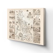
One of the most historically significant maps ever published of the Philippines, this depiction of the islands while under Spanish Colonial rule, is referred to as the "Mother of all Philippine Maps." The map was the result of a collaboration between Spanish Jesuit cartographer and missionary Pedro Murillo Velarde and two native Filipinos, engraver Nicolas de la Cruz Bagay and artist Francisco Suarez. These culturally significant engravings were seized by the British during their occupation of Manila from 1762 to 1764. The engravings were sent back to Britain, where multiple printings of the map were produced before their eventual destruction. The map was created after a direct order from Spanish King Philip V.
This depiction illustrated maritime routes from Manila to Spain and modern-day Latin America. This production was widely reprinted and was the first and most crucial scientific map of the Philippines. The Islands had been discovered two centuries prior by Portuguese explorer Ferdinand Magellan who claimed the archipelago for Spain. Under Spanish rule, the islands were unified under one government, and Catholic missionaries established churches and colonies throughout the region. These missionaries also founded schools, hospitals, and even a university. Spain would maintain colonial rule of the region until 1898.
The Philippines harbored a diverse range of indigenous people, and the map illustrates eight ethnic groups that inhabited the islands with four depictions of significant cities and islands. The distinctive aesthetic and historical significance make this map an authentic piece of cartographical history and immediately transport the viewer back in time.
Our ready-to-hang canvas wall art prints are made in the USA using the highest quality materials with professional craftsmanship. This beautiful artwork is a perfect addition to your themed decor. Historic prints look great in the home, study or office.
|
Why are we showing these items?
Booth
Historic Prints |

|


-
Refine your browsing experience
We can show you more items that are exactly like the original item, or we can show you items that are similar in spirit. By default we show you a mix.
This item has been added to your cart
 HISTORIX Vintage 1734 Philippines Map Canvas Art - 20x24x1.5 Inch Canvas Wrap Vi added to cart.
16 available in stock
HISTORIX Vintage 1734 Philippines Map Canvas Art - 20x24x1.5 Inch Canvas Wrap Vi added to cart.
16 available in stock
View Cart or continue shopping.
 Please wait while we finish adding this item to your cart.
Get an item reminder
We'll email you a link to your item now and follow up with a single reminder (if you'd like one). That's it! No spam, no hassle.
Already have an account?
Log in and add this item to your wish list.