HISTORIX Vintage 1886 Arkansas State Map and 50 similar items


Free Shipping
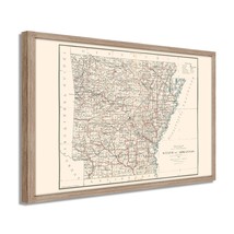
HISTORIX Vintage 1886 Arkansas State Map Poster - 19x25 Inch White Framed Vintag
$275.99 - $382.99
View full item details »

Shipping options
Seller handling time is 1 business day Details
FREE via to United States
Return policy
Full refund available for DOAs
Details
Purchase protection
Payment options
PayPal accepted
PayPal Credit accepted
Venmo accepted
PayPal, MasterCard, Visa, Discover, and American Express accepted
Maestro accepted
Amazon Pay accepted
Nuvei accepted
View full item details »
Shipping options
Seller handling time is 1 business day Details
FREE via to United States
Return policy
Full refund available for DOAs
Details
Purchase protection
Payment options
PayPal accepted
PayPal Credit accepted
Venmo accepted
PayPal, MasterCard, Visa, Discover, and American Express accepted
Maestro accepted
Amazon Pay accepted
Nuvei accepted
Item traits
| Category: | |
|---|---|
| Quantity Available: |
16 in stock |
| Condition: |
New |
| ASIN: |
B09G2Q6M92 |
| Item Name: |
1886 State of Arkansas |
| Item Type Keyword: |
prints |
| Product Site Launch Date: |
2021-09-16T02:24:48.468Z |
| Unspsc Code: |
60121013 |
| colors: | |
| sizes: |
Listing details
| Seller policies: | |
|---|---|
| Shipping discount: |
Seller pays shipping for this item. |
| Posted for sale: |
April 13 |
| Item number: |
1738901268 |
Item description
Produced under the direction of prolific General Land Office surveyor AF Dinsmore, this detailed illustration shows Arkansas in a time of economic growth and development. The American Civil War had ravaged the land in Arkansas, and farmers were still recovering from the financial devastation wrested upon them during the conflict. As the so-called cotton belt expanded into Oklahoma and Texas, railroad expansion had increased access and allowed farmers to gain momentum heading to the turn of the century.
Arkansas had achieved Statehood in 1836, and the later decades of the 19th century saw the state experiencing rapid growth and industrialization. This transformation from a mostly agricultural economy drew immigrants to the state and saw the establishment of many communities. In the 1880s, mining industries also found a foothold in the state, expanding economic opportunity and diversity.
These maps were critical in the westward expansion of America and, by this time, were primarily re-written to reflect growing rail line construction following destruction during the Civil War. However, the state had initially voted to remain loyal to the Union, following the outbreak of the war in 1861 they chose secession. The state's proximity to the Mississippi River proved critical to Confederate efforts during the conflict. The Union took control of the Northern region following their decisive victory at the Battle of Pea Ridge, which proved crucial for Union control of the Trans-Mississippi Theater. With an unmistakable aesthetic and stunning detail, this is truly an authentic piece of American cartographical history.
Our ready-to-hang wall art are printed and framed in the USA using the highest quality materials with professional craftsmanship. This beautiful artwork is a perfect addition to your themed decor. Historic prints look great in the home, study or office. They also make an unforgettable gift.
|
Why are we showing these items?
Booth
Historic Prints |

|


-
Refine your browsing experience
We can show you more items that are exactly like the original item, or we can show you items that are similar in spirit. By default we show you a mix.


This item has been added to your cart
 HISTORIX Vintage 1886 Arkansas State Map Poster - 19x25 Inch White Framed Vintag added to cart.
16 available in stock
HISTORIX Vintage 1886 Arkansas State Map Poster - 19x25 Inch White Framed Vintag added to cart.
16 available in stock
View Cart or continue shopping.
 Please wait while we finish adding this item to your cart.
Get an item reminder
We'll email you a link to your item now and follow up with a single reminder (if you'd like one). That's it! No spam, no hassle.
Already have an account?
Log in and add this item to your wish list.