1734 Philippines Map - Framed Vintage and 50 similar items


Free Shipping
1734 Philippines Map - Framed Vintage Philippines Wall Art Poster Print
$279.99 - $326.99
View full item details »

Shipping options
Estimated to arrive by Mon, Jun 2nd.
Details
FREE via UPS Ground (1 to 5 business days) to United States
Return policy
Full refund available for DOAs
Details
Purchase protection
Payment options
PayPal accepted
PayPal Credit accepted
Venmo accepted
PayPal, MasterCard, Visa, Discover, and American Express accepted
Maestro accepted
Amazon Pay accepted
Nuvei accepted
View full item details »
Shipping options
Estimated to arrive by Mon, Jun 2nd.
Details
FREE via UPS Ground (1 to 5 business days) to United States
Return policy
Full refund available for DOAs
Details
Purchase protection
Payment options
PayPal accepted
PayPal Credit accepted
Venmo accepted
PayPal, MasterCard, Visa, Discover, and American Express accepted
Maestro accepted
Amazon Pay accepted
Nuvei accepted
Item traits
| Category: | |
|---|---|
| Quantity Available: |
64 in stock |
| Condition: |
New |
| Subject: |
Maps |
| Style: |
Vintage |
| Type: |
Wall Art |
| Features: |
Museum Quality |
| Theme: |
History |
| Artist: |
Various |
| Region of Origin: |
Made in the USA |
| Framing: |
Framed |
| Brand: |
HISTORIX |
| Sizes: | |
| Colors: |
Listing details
| Seller policies: | |
|---|---|
| Shipping discount: |
Seller pays shipping for this item. |
| Posted for sale: |
More than a week ago |
| Item number: |
1738792622 |
Item description
Feature Points
VINTAGE MAP FRAMED: You?ll love this high-quality framed historic reproduction of 1734 Philippines Map Poster. Our ready-to-hang maps are printed and framed in the USA by professional art framers using the highest quality materials. Each order is inspected for quality. This beautiful artwork is a perfect addition to your themed decor. Vintage maps look great in the home, study or office. They also make an unforgettable gift.
A LOOK BACK AT HISTORY: This is an impressive, historic reproduction of 1734 Philippines Wall Map. A true piece of history. Historic prints beautifully link the past with the present. You may find yourself staring at your historic wall art for hours in amazement. See our product description section for more fascinating information about this historic map and its significance.
PREMIUM QUALITY: To display this amazing piece of history, we use museum-quality heavyweight (230gsm), fine art print matte paper. Our paper is acid-free which allows the print to retain its color quality for generations. Our paper displays vintage map art with accurate color reproduction. This high quality print will be a wonderful addition to your vintage-themed wall.
READY TO HANG: This high-quality frame displays art beautifully in almost any environment. The frame is made out of poplar wood (for black and white) and pine wood (for walnut and natural) with a matte finish. The frame profile is 1.5 inches high and 0.75 (for size 24x20) and 1.125 (for size 30x24 inches wide. To protect artwork, we use high-quality, lightweight, shatter-resistant frame-grade acrylic. Frames arrive ready-to-hang, preinstalled with hanging hardware.
HISTORIC PRINTS: We love history and art. Sometimes old maps have tears, folds, stamps, separations and other blemishes. We digitally restore and enhance maps while keeping its historical character. Our framed prints are made-to-order in the USA by professional art framers. Customers all over the world love our historic prints and we know you will too.
Additional Information
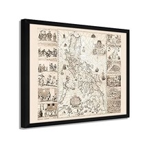
One of the most historically significant maps ever published of the Philippines, this depiction of the islands while under Spanish Colonial rule, is referred to as the "Mother of all Philippine Maps." The map was the result of a collaboration between Spanish Jesuit cartographer and missionary Pedro Murillo Velarde and two native Filipinos, engraver Nicolas de la Cruz Bagay and artist Francisco Suarez. These culturally significant engravings were seized by the British during their occupation of Manila from 1762 to 1764. The engravings were sent back to Britain, where multiple printings of the map were produced before their eventual destruction. The map was created after a direct order from Spanish King Philip V.
This depiction illustrated maritime routes from Manila to Spain and modern-day Latin America. This production was widely reprinted and was the first and most crucial scientific map of the Philippines. The Islands had been discovered two centuries prior by Portuguese explorer Ferdinand Magellan who claimed the archipelago for Spain. Under Spanish rule, the islands were unified under one government, and Catholic missionaries established churches and colonies throughout the region. These missionaries also founded schools, hospitals, and even a university. Spain would maintain colonial rule of the region until 1898.
The Philippines harbored a diverse range of indigenous people, and the map illustrates eight ethnic groups that inhabited the islands with four depictions of significant cities and islands. The distinctive aesthetic and historical significance make this map an authentic piece of cartographical history and immediately transport the viewer back in time.
Our ready-to-hang wall art are printed and framed in the USA using the highest quality materials with professional craftsmanship. This beautiful artwork is a perfect addition to your themed decor. Historic prints look great in the home, study or office.


 - $15.00")


-
Refine your browsing experience
We can show you more items that are exactly like the original item, or we can show you items that are similar in spirit. By default we show you a mix.


 *Francine De... - $75.00")


 - $12.00")


This item has been added to your cart
 1734 Philippines Map - Framed Vintage Philippines Wall Art Poster Print added to cart.
64 available in stock
1734 Philippines Map - Framed Vintage Philippines Wall Art Poster Print added to cart.
64 available in stock
View Cart or continue shopping.
 Please wait while we finish adding this item to your cart.
Get an item reminder
We'll email you a link to your item now and follow up with a single reminder (if you'd like one). That's it! No spam, no hassle.
Already have an account?
Log in and add this item to your wish list.