HISTORIX Vintage 1916 Egypt Map Poster Print and similar items


Free Shipping
HISTORIX Vintage 1916 Egypt Map Poster Print - 18x24 Inch Vintage Excelsior Map
$39.99
View full item details »

Shipping options
Seller handling time is 2 business days Details
FREE via to United States
Return policy
Full refund available for DOAs
Details
Purchase protection
Payment options
PayPal accepted
PayPal Credit accepted
Venmo accepted
PayPal, MasterCard, Visa, Discover, and American Express accepted
Maestro accepted
Amazon Pay accepted
Nuvei accepted
View full item details »
Shipping options
Seller handling time is 2 business days Details
FREE via to United States
Return policy
Full refund available for DOAs
Details
Purchase protection
Payment options
PayPal accepted
PayPal Credit accepted
Venmo accepted
PayPal, MasterCard, Visa, Discover, and American Express accepted
Maestro accepted
Amazon Pay accepted
Nuvei accepted
Item traits
| Category: | |
|---|---|
| Quantity Available: |
8 in stock |
| Condition: |
New |
| UPC: |
705514888990 |
| MPN: |
ENMAP06621824 |
| EAN: |
0705514888990 |
| Color: |
Natural |
| binding: |
unbound |
| format: |
unbound |
| language: |
english |
| manufacturer: |
HISTORIX |
| Externally Assigned Product Identifier: |
0705514888990 |
| Bullet Point: | |
| Publication Date: |
1916T |
| Product Description: | |
| Brand: |
HISTORIX |
| Unspsc Code: |
55101500 |
| Paper Finish: |
matte |
| Map Scale: |
1000 |
| Item Name: | |
| Item Type Keyword: |
prints |
| Product Site Launch Date: |
2023-08-28T08:40:42.969Z |
| Part Number: |
ENMAP06621824 |
Listing details
| Seller policies: | |
|---|---|
| Shipping discount: |
Seller pays shipping for this item. |
| Posted for sale: |
More than a week ago |
| Item number: |
1736374871 |
Item description
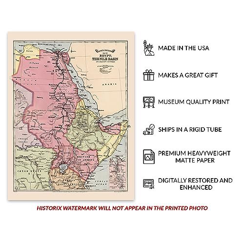
Produced by prominent American cartographer George Washington Bacon in 1916, this depiction of the Nile Basin shows the region in a period of significant transformation as modern technology entered the area and created new economic opportunities for some 238 million residents of the Nile Basin. Bacon started producing maps of London before branching out and creating works that focused on other parts of the globe. Bacon produced maps based on engravings made by English-born artist and lithographer Edward Weller, who was an early adopter of plate-based prints that could be utilized multiple times to mass-produce maps and increase productivity.
The Nile Basin remains one of the most notable drainage basins in the world and is among the most iconic places for exploration due to its vast size. The source was not identified until the discovery of the Blue Nile by Scottish Explorer James Bruce in 1870 though the head of the White Nile remains disputed to this day. The Nile River drains into the Mediterranean Sea and is considered the longest river in the world, though there continue to be claims that the Amazon is longer. The Nile River supports the region economically, providing fertile lands for agriculture as well as fishing and tourism.
This map bears a distinctive aesthetic that makes it immediately recognizable with bold colors and crisp lines that are characteristic of the early twentieth century. This is an authentic piece of international cartographical history that creates a link between the present and the past.
Additional Details
------------------------------
Bullet point: VINTAGE MAP REPRODUCTION: You?ll love this high quality historic reproduction of 1916 Egypt Map Poster Print. Our museum quality prints are archival grade, which means it will look great and last without fading for over 100 years. Our print to order maps are made in the USA and each map is inspected for quality. This beautiful artwork is a perfect addition to your themed decor. Vintage maps look great in the home, study or office. They make a perfect gift as well.
Product description:
Produced by prominent American cartographer George Washington Bacon in 1916, this depiction of the Nile Basin shows the region in a period of significant transformation as modern technology entered the area and created new economic opportunities for some 238 million residents of the Nile Basin. Bacon started producing maps of London before branching out and creating works that focused on other parts of the globe. Bacon produced maps based on engravings made by English-born artist and lithographer Edward Weller, who was an early adopter of plate-based prints that could be utilized multiple times to mass-produce maps and increase productivity.
The Nile Basin remains one of the most notable drainage basins in the world and is among the most iconic places for exploration due to its vast size. The source was not identified until the discovery of the Blue Nile by Scottish Explorer James Bruce in 1870 though the head of the White Nile remains disputed to this day. The Nile River drains into the Mediterranean Sea and is considered the longest river in the world, though there continue to be claims that the Amazon is longer. The Nile River supports the region economically, providing fertile lands for agriculture as well as fishing and tourism.
This map bears a distinctive aesthetic that makes it immediately recognizable with bold colors and crisp lines that are characteristic of the early twentieth century. This is an authentic piece of international cartographical history that creates a link between the present and the past.
Format: wall_map
Loading
This item has been added to your cart
 HISTORIX Vintage 1916 Egypt Map Poster Print - 18x24 Inch Vintage Excelsior Map added to cart.
8 available in stock
HISTORIX Vintage 1916 Egypt Map Poster Print - 18x24 Inch Vintage Excelsior Map added to cart.
8 available in stock
View Cart or continue shopping.
 Please wait while we finish adding this item to your cart.
Get an item reminder
We'll email you a link to your item now and follow up with a single reminder (if you'd like one). That's it! No spam, no hassle.
Already have an account?
Log in and add this item to your wish list.