HISTORIX Vintage 1776 New York City Map and similar items


Free Shipping
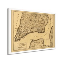
HISTORIX Vintage 1776 New York City Map Print - 25x33 Inch White Framed Vintage
$315.99
View full item details »

Shipping options
Seller handling time is 2 business days Details
FREE via to United States
Return policy
Full refund available for DOAs
Details
Purchase protection
Payment options
PayPal accepted
PayPal Credit accepted
Venmo accepted
PayPal, MasterCard, Visa, Discover, and American Express accepted
Maestro accepted
Amazon Pay accepted
Nuvei accepted
View full item details »
Shipping options
Seller handling time is 2 business days Details
FREE via to United States
Return policy
Full refund available for DOAs
Details
Purchase protection
Payment options
PayPal accepted
PayPal Credit accepted
Venmo accepted
PayPal, MasterCard, Visa, Discover, and American Express accepted
Maestro accepted
Amazon Pay accepted
Nuvei accepted
Item traits
| Category: | |
|---|---|
| Quantity Available: |
8 in stock |
| Condition: |
New |
| ASIN: |
B0982G2KQ6 |
| EAN: |
0723592010591 |
| UPC: |
723592010591 |
| color: |
White Frame |
| Map Type: |
Road |
| Externally Assigned Product Identifier: |
0723592010591 |
| Item Shape: |
Rectangular |
| Bullet Point: | |
| Product Description: | |
| brand: |
HISTORIX |
| Unspsc Code: |
44103112 |
| Paper Finish: |
matte |
| Item Name: | |
| Item Type Keyword: |
artwork |
| Product Site Launch Date: |
2021-06-27T19:29:51.638Z |
| material: |
Acrylic |
| size: |
25x33 Inch |
| style: |
Retro |
Listing details
| Seller policies: | |
|---|---|
| Shipping discount: |
Seller pays shipping for this item. |
| Posted for sale: |
More than a week ago |
| Item number: |
1736292204 |
Item description
Published in 1776, this depiction of the iconic New York City was created at a time of great upheaval in the colonies. These years marked the New York and New Jersey Campaigns where skirmishes between colonials fed up with British rule and taxation had taken up arms and were fighting troops throughout the eastern seaboard. The Continental Army under General George Washington had been pushed out of New York City. It was posted in New Jersey, where they successfully contained British General Sir William Howe back into New York. This success, however, did not keep the British from maintaining control of New York’s port until their eventual defeat in 1873.
This map shows the Road to Kings Bridge, where the Rebels mean to make a stand and is a truly authentic piece of cartographical history. This map was published in the same year, but before, The Great Fire of New York ravaged the city, destroying some twenty-five percent of the city. This destruction was blamed on residents by the British troops, with civilians blaming the soldiers themselves. The fire had a significant effect on the British occupation as they seized private property and churches to create makeshift barracks and prisons. Crime and poor sanitation would mar the city until the eventual defeat of the British in 1873.
New York City has always been tolerant of immigrants, and the port remained the busiest in the world until 1984, its importance as the cultural and financial capital of the United States cannot be underestimated.
Our ready-to-hang wall art are printed and framed in the USA using the highest quality materials with professional craftsmanship. This beautiful artwork is a perfect addition to your themed decor. Historic prints look great in the home, study or office. They also make an unforgettable gift.
Additional Details
------------------------------
Bullet point: VINTAGE MAP FRAMED: You?ll love this high-quality white framed historic reproduction of 1776 New York City Map . Our ready-to-hang maps are printed and framed in the USA by professional art framers using the highest quality materials. Each order is inspected for quality. This beautiful artwork is a perfect addition to your themed decor. Vintage maps look great in the home, study or office. They also make an unforgettable gift.
Product description:
Published in 1776, this depiction of the iconic New York City was created at a time of great upheaval in the colonies. These years marked the New York and New Jersey Campaigns where skirmishes between colonials fed up with British rule and taxation had taken up arms and were fighting troops throughout the eastern seaboard. The Continental Army under General George Washington had been pushed out of New York City. It was posted in New Jersey, where they successfully contained British General Sir William Howe back into New York. This success, however, did not keep the British from maintaining control of New York’s port until their eventual defeat in 1873.
This map shows the Road to Kings Bridge, where the Rebels mean to make a stand and is a truly authentic piece of cartographical history. This map was published in the same year, but before, The Great Fire of New York ravaged the city, destroying some twenty-five percent of the city. This destruction was blamed on residents by the British troops, with civilians blaming the soldiers themselves. The fire had a significant effect on the British occupation as they seized private property and churches to create makeshift barracks and prisons. Crime and poor sanitation would mar the city until the eventual defeat of the British in 1873.
New York City has always been tolerant of immigrants, and the port remained the busiest in the world until 1984, its importance as the cultural and financial capital of the United States cannot be underestimated.
Our ready-to-hang wall art are printed and framed in the USA using the highest quality materials with professional craftsmanship. This beautiful artwork is a perfect addition to your themed decor. Historic prints look great in the home, study or office. They also make an unforgettable gift.
Loading
This item has been added to your cart
 HISTORIX Vintage 1776 New York City Map Print - 25x33 Inch White Framed Vintage added to cart.
8 available in stock
HISTORIX Vintage 1776 New York City Map Print - 25x33 Inch White Framed Vintage added to cart.
8 available in stock
View Cart or continue shopping.
 Please wait while we finish adding this item to your cart.
Get an item reminder
We'll email you a link to your item now and follow up with a single reminder (if you'd like one). That's it! No spam, no hassle.
Already have an account?
Log in and add this item to your wish list.