HISTORIX Vintage 1883 Watertown South Dakota and similar items


Free Shipping
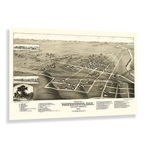
HISTORIX Vintage 1883 Watertown South Dakota Map Poster - 24x36 Inch Old Bird's
$59.99
View full item details »

Shipping options
Seller handling time is 2 business days Details
FREE via to United States
Return policy
Full refund available for DOAs
Details
Purchase protection
Payment options
PayPal accepted
PayPal Credit accepted
Venmo accepted
PayPal, MasterCard, Visa, Discover, and American Express accepted
Maestro accepted
Amazon Pay accepted
Nuvei accepted
View full item details »
Shipping options
Seller handling time is 2 business days Details
FREE via to United States
Return policy
Full refund available for DOAs
Details
Purchase protection
Payment options
PayPal accepted
PayPal Credit accepted
Venmo accepted
PayPal, MasterCard, Visa, Discover, and American Express accepted
Maestro accepted
Amazon Pay accepted
Nuvei accepted
Item traits
| Category: | |
|---|---|
| Quantity Available: |
8 in stock |
| Condition: |
New |
| UPC: |
705514886217 |
| MPN: |
ENMAP0620_2436 |
| Style: |
Vintage/Retro |
| ASIN: |
B0C4D7PKVT |
| EAN: |
0705514886217 |
| Color: |
Natural |
| binding: |
map |
| format: |
map |
| manufacturer: |
historix |
| Externally Assigned Product Identifier: |
0705514886217 |
| Bullet Point: | |
| theme: |
Book |
| Product Description: | |
| Brand: |
HISTORIX |
| Unspsc Code: |
55101500 |
| Special Feature: |
Unframed |
| Item Name: | |
| Item Type Keyword: |
prints |
| Paper Size: |
24 x 36 |
| Part Number: |
ENMAP0620_2436 |
Listing details
| Seller policies: | |
|---|---|
| Shipping discount: |
Seller pays shipping for this item. |
| Posted for sale: |
More than a week ago |
| Item number: |
1735819520 |
Item description
Produced and published during a period of significant prosperity, Watertown became a transportation hub for the region as the expansion of rail lines across the American West opened access and allowed for numerous towns and communities to be established throughout the latter portion of the nineteenth century. In the years following the conclusion of the American Civil War, westward expansion was flourishing, and Watertown was considered to be named the State Capital when South Dakota achieved statehood in 1889, only six years after this map's publication. Watertown is located on the banks of the Big Sioux River, a tributary of the Mississippi River that allowed for early traders to move goods into the area from larger markets on the Mississippi.
This bird's eye perspective was produced by the prominent cartographer Joseph John Stoner in partnership with his frequent collaborators, Beck Pauli, whose lithography firm was based in Milwaukee. This trio created numerous panoramic maps of various towns and cities across the United States designed as marketing materials to entice residents and merchants alike by promoting notable civic features, natural attractions, and economic opportunities that brought immigrants from across America, Eastern, and Western Europe that established neighborhoods and communities based on cultural lines, many of which exist to this day.
In the years following the conclusion of the American Civil War, the region continued to o and expand. This is a unique piece of American cartographical history with a distinct style that transports the viewer back in time.
Additional Details
------------------------------
Bullet point: VINTAGE MAP REPRODUCTION: You?ll love this high quality historic reproduction of 1883 Watertown South Dakota Map Poster. Our museum quality prints are archival grade, which means it will look great and last without fading for over 100 years. Our print to order maps are made in the USA and each map is inspected for quality. This beautiful artwork is a perfect addition to your themed decor. Vintage maps look great in the home, study or office. They make a perfect gift as well.
Product description:
Produced and published during a period of significant prosperity, Watertown became a transportation hub for the region as the expansion of rail lines across the American West opened access and allowed for numerous towns and communities to be established throughout the latter portion of the nineteenth century. In the years following the conclusion of the American Civil War, westward expansion was flourishing, and Watertown was considered to be named the State Capital when South Dakota achieved statehood in 1889, only six years after this map's publication. Watertown is located on the banks of the Big Sioux River, a tributary of the Mississippi River that allowed for early traders to move goods into the area from larger markets on the Mississippi.
This bird's eye perspective was produced by the prominent cartographer Joseph John Stoner in partnership with his frequent collaborators, Beck Pauli, whose lithography firm was based in Milwaukee. This trio created numerous panoramic maps of various towns and cities across the United States designed as marketing materials to entice residents and merchants alike by promoting notable civic features, natural attractions, and economic opportunities that brought immigrants from across America, Eastern, and Western Europe that established neighborhoods and communities based on cultural lines, many of which exist to this day.
In the years following the conclusion of the American Civil War, the region continued to o and expand. This is a unique piece of American cartographical history with a distinct style that transports the viewer back in time.
Style: Vintage
Loading
This item has been added to your cart
 HISTORIX Vintage 1883 Watertown South Dakota Map Poster - 24x36 Inch Old Bird's added to cart.
8 available in stock
HISTORIX Vintage 1883 Watertown South Dakota Map Poster - 24x36 Inch Old Bird's added to cart.
8 available in stock
View Cart or continue shopping.
 Please wait while we finish adding this item to your cart.
Get an item reminder
We'll email you a link to your item now and follow up with a single reminder (if you'd like one). That's it! No spam, no hassle.
Already have an account?
Log in and add this item to your wish list.