HISTORIX Vintage 1852 York Pennsylvania Map and similar items


Free Shipping
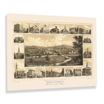
HISTORIX Vintage 1852 York Pennsylvania Map Print - 18x24 Inch Old View of York
$39.99
View full item details »

Shipping options
Seller handling time is 2 business days Details
FREE via to United States
Return policy
Full refund available for DOAs
Details
Purchase protection
Payment options
PayPal accepted
PayPal Credit accepted
Venmo accepted
PayPal, MasterCard, Visa, Discover, and American Express accepted
Maestro accepted
Amazon Pay accepted
Nuvei accepted
View full item details »
Shipping options
Seller handling time is 2 business days Details
FREE via to United States
Return policy
Full refund available for DOAs
Details
Purchase protection
Payment options
PayPal accepted
PayPal Credit accepted
Venmo accepted
PayPal, MasterCard, Visa, Discover, and American Express accepted
Maestro accepted
Amazon Pay accepted
Nuvei accepted
Item traits
| Category: | |
|---|---|
| Quantity Available: |
8 in stock |
| Condition: |
New |
| UPC: |
705514893147 |
| MPN: |
ENMAP06021824A |
| EAN: |
0705514893147 |
| Paint Type: |
Watercolor |
| Color: |
Natural |
| manufacturer: |
HISTORIX |
| Externally Assigned Product Identifier: |
0705514893147 |
| Item Shape: |
Rectangular |
| Age Range Description: |
Adult |
| Bullet Point: | |
| Product Description: | |
| Brand: |
HISTORIX |
| Unspsc Code: |
55101500 |
| orientation: |
Landscape |
| Item Name: | |
| Item Type Keyword: |
prints |
| Mounting Type: |
Wall Mount |
| Part Number: |
ENMAP06021824A |
| Wall Art Form: |
poster |
| Target Gender: |
unisex |
Listing details
| Seller policies: | |
|---|---|
| Shipping discount: |
Seller pays shipping for this item. |
| Posted for sale: |
More than a week ago |
| Item number: |
1735817478 |
Item description
The rich and storied history of York, Pennsylvania dates back to its founding in 1741 by residents of Philadelphia and immigrants from the town's namesake in England. York was the Capital of the Continental Congress from 1877 to 1878 and is where the Articles of Confederation were drafted and adopted, leading to the American Revolution. This depiction was published by German-born lithographer Edward Sachse who was one of the early pioneers of the bird's eye perspective style and was based out of Baltimore. This depiction includes noted buildings, including churches and civic buildings highlighted in the border, which is indicative of the early panoramic maps and sets this publication apart.
As York developed during the nineteenth century, it attracted large numbers of Eastern and Western European immigrants who established neighborhoods and communities along cultural lines, many of which exist to this day. The city claims to be the first Capital of the United States. However, there is a dispute among historians regarding which document between the Articles of Confederation and the Declaration of Independence is the first true legal document stating freedom from British colonial rule. Sachse's work is characterized by his detail and crisp lines, which give a classic aesthetic and distinctive style that is immediately recognizable.
The American Civil War loomed as York, and the rest of the Nation grew during the mid-nineteenth century. York became the northernmost city to come under Confederate control during the conflict. This remains a unique piece of American cartographical history.
Additional Details
------------------------------
Bullet point: VINTAGE MAP REPRODUCTION: You?ll love this high quality historic reproduction of 1852 York Pennsylvania Map Poster. Our museum quality prints are archival grade, which means it will look great and last without fading for over 100 years. Our print to order maps are made in the USA and each map is inspected for quality. This beautiful artwork is a perfect addition to your themed decor. Vintage maps look great in the home, study or office. They make a perfect gift as well.
Product description:
The rich and storied history of York, Pennsylvania dates back to its founding in 1741 by residents of Philadelphia and immigrants from the town's namesake in England. York was the Capital of the Continental Congress from 1877 to 1878 and is where the Articles of Confederation were drafted and adopted, leading to the American Revolution. This depiction was published by German-born lithographer Edward Sachse who was one of the early pioneers of the bird's eye perspective style and was based out of Baltimore. This depiction includes noted buildings, including churches and civic buildings highlighted in the border, which is indicative of the early panoramic maps and sets this publication apart.
As York developed during the nineteenth century, it attracted large numbers of Eastern and Western European immigrants who established neighborhoods and communities along cultural lines, many of which exist to this day. The city claims to be the first Capital of the United States. However, there is a dispute among historians regarding which document between the Articles of Confederation and the Declaration of Independence is the first true legal document stating freedom from British colonial rule. Sachse's work is characterized by his detail and crisp lines, which give a classic aesthetic and distinctive style that is immediately recognizable.
The American Civil War loomed as York, and the rest of the Nation grew during the mid-nineteenth century. York became the northernmost city to come under Confederate control during the conflict. This remains a unique piece of American cartographical history.
Loading
This item has been added to your cart
 HISTORIX Vintage 1852 York Pennsylvania Map Print - 18x24 Inch Old View of York added to cart.
8 available in stock
HISTORIX Vintage 1852 York Pennsylvania Map Print - 18x24 Inch Old View of York added to cart.
8 available in stock
View Cart or continue shopping.
 Please wait while we finish adding this item to your cart.
Get an item reminder
We'll email you a link to your item now and follow up with a single reminder (if you'd like one). That's it! No spam, no hassle.
Already have an account?
Log in and add this item to your wish list.