HISTORIX Vintage 1869 Decatur Illinois Map and similar items


Free Shipping
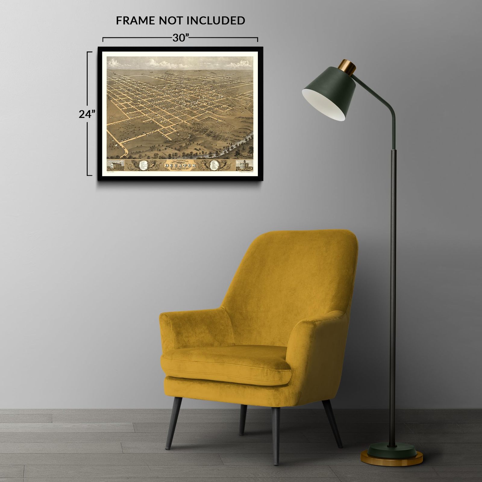
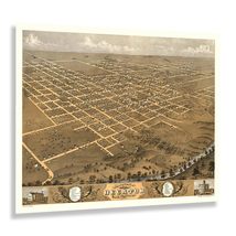
HISTORIX Vintage 1869 Decatur Illinois Map Poster - 24x30 Inch Vintage Bird's Ey
$54.99
View full item details »

Shipping options
Seller handling time is 2 business days Details
FREE via to United States
Return policy
Full refund available for DOAs
Details
Purchase protection
Payment options
PayPal accepted
PayPal Credit accepted
Venmo accepted
PayPal, MasterCard, Visa, Discover, and American Express accepted
Maestro accepted
Amazon Pay accepted
Nuvei accepted
View full item details »
Shipping options
Seller handling time is 2 business days Details
FREE via to United States
Return policy
Full refund available for DOAs
Details
Purchase protection
Payment options
PayPal accepted
PayPal Credit accepted
Venmo accepted
PayPal, MasterCard, Visa, Discover, and American Express accepted
Maestro accepted
Amazon Pay accepted
Nuvei accepted
Item traits
| Category: | |
|---|---|
| Quantity Available: |
8 in stock |
| Condition: |
New |
| UPC: |
705514888945 |
| MPN: |
ENMAP06592430 |
| EAN: |
0705514888945 |
| Color: |
Natural |
| binding: |
unbound |
| format: |
unbound |
| language: |
english |
| manufacturer: |
HISTORIX |
| Externally Assigned Product Identifier: |
0705514888945 |
| Bullet Point: | |
| Publication Date: |
1869T |
| Product Description: | |
| Brand: |
HISTORIX |
| Unspsc Code: |
55101500 |
| Paper Finish: |
matte |
| Map Scale: |
1000 |
| Item Name: | |
| Item Type Keyword: |
prints |
| Product Site Launch Date: |
2023-08-19T21:17:07.473Z |
| Part Number: |
ENMAP06592430 |
Listing details
| Seller policies: | |
|---|---|
| Shipping discount: |
Seller pays shipping for this item. |
| Posted for sale: |
More than a week ago |
| Item number: |
1735808328 |
Item description
Founded in 1829 on the banks of the Sangamon River and Lake Decatur in central Illinois, Decatur is the seventeenth largest city in the state and an important agricultural hub for the region. Decatur is home to the Edward P. Irving House, designed by iconic American Architect Frank Lloyd Wright. Decatur was also the first home of legendary American President Abraham Lincoln, who would go on to become one of the most celebrated Presidents and known for ending slavery in the United States and leading the Union Army during the American Civil War. Decatur has an economy based primarily on industrial manufacturing and agriculture.
Produced by noted Prussian-born Albert Ruger, cartographer and lithographer, this bird's eye perspective captures Decatur in a period of significant growth and transformation following the conclusion of the civil war. The region experienced tremendous growth as Southern Americans flocked to the region, eager for economic opportunities in the farms, mills, and manufacturing facilities found in the region. Decatur features a historic downtown and was awarded the All-America City Award in 1960 for its classic American small-town culture. Decatur features seventy-one distinct neighborhoods, many of which date back to this period of expansion during reconstruction.
Ruger's bird's eye perspectives bear a distinctive style and unique aesthetic that immediately transport the viewer back in time, creating a link between the present and the past while providing insight into how towns and communities have grown and evolved throughout their history and the influence they have on the region.
Additional Details
------------------------------
Bullet point: VINTAGE MAP REPRODUCTION: You?ll love this high quality historic reproduction of 1869 Decatur Illinois Map Poster. Our museum quality prints are archival grade, which means it will look great and last without fading for over 100 years. Our print to order maps are made in the USA and each map is inspected for quality. This beautiful artwork is a perfect addition to your themed decor. Vintage maps look great in the home, study or office. They make a perfect gift as well.
Product description:
Founded in 1829 on the banks of the Sangamon River and Lake Decatur in central Illinois, Decatur is the seventeenth largest city in the state and an important agricultural hub for the region. Decatur is home to the Edward P. Irving House, designed by iconic American Architect Frank Lloyd Wright. Decatur was also the first home of legendary American President Abraham Lincoln, who would go on to become one of the most celebrated Presidents and known for ending slavery in the United States and leading the Union Army during the American Civil War. Decatur has an economy based primarily on industrial manufacturing and agriculture.
Produced by noted Prussian-born Albert Ruger, cartographer and lithographer, this bird's eye perspective captures Decatur in a period of significant growth and transformation following the conclusion of the civil war. The region experienced tremendous growth as Southern Americans flocked to the region, eager for economic opportunities in the farms, mills, and manufacturing facilities found in the region. Decatur features a historic downtown and was awarded the All-America City Award in 1960 for its classic American small-town culture. Decatur features seventy-one distinct neighborhoods, many of which date back to this period of expansion during reconstruction.
Ruger's bird's eye perspectives bear a distinctive style and unique aesthetic that immediately transport the viewer back in time, creating a link between the present and the past while providing insight into how towns and communities have grown and evolved throughout their history and the influence they have on the region.
Format: wall_map
Loading
This item has been added to your cart
 HISTORIX Vintage 1869 Decatur Illinois Map Poster - 24x30 Inch Vintage Bird's Ey added to cart.
8 available in stock
HISTORIX Vintage 1869 Decatur Illinois Map Poster - 24x30 Inch Vintage Bird's Ey added to cart.
8 available in stock
View Cart or continue shopping.
 Please wait while we finish adding this item to your cart.
Get an item reminder
We'll email you a link to your item now and follow up with a single reminder (if you'd like one). That's it! No spam, no hassle.
Already have an account?
Log in and add this item to your wish list.