HISTORIX Vintage 1877 Portsmouth New and similar items


Free Shipping
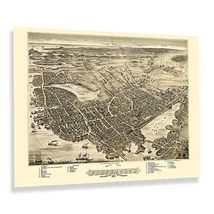
HISTORIX Vintage 1877 Portsmouth New Hampshire Map Print - 18x24 Inch Vintage Bi
$39.99
View full item details »

Shipping options
Seller handling time is 2 business days Details
FREE via to United States
Return policy
Full refund available for DOAs
Details
Purchase protection
Payment options
PayPal accepted
PayPal Credit accepted
Venmo accepted
PayPal, MasterCard, Visa, Discover, and American Express accepted
Maestro accepted
Amazon Pay accepted
Nuvei accepted
View full item details »
Shipping options
Seller handling time is 2 business days Details
FREE via to United States
Return policy
Full refund available for DOAs
Details
Purchase protection
Payment options
PayPal accepted
PayPal Credit accepted
Venmo accepted
PayPal, MasterCard, Visa, Discover, and American Express accepted
Maestro accepted
Amazon Pay accepted
Nuvei accepted
Item traits
| Category: | |
|---|---|
| Quantity Available: |
8 in stock |
| Condition: |
New |
| UPC: |
705514885975 |
| MPN: |
ENMAP0614_1824 |
| ASIN: |
B0C3CLTP85 |
| EAN: |
0705514885975 |
| Color: |
Natural |
| binding: |
wall_chart |
| format: |
wall_chart |
| language: |
english |
| manufacturer: |
historix |
| Map Type: |
Historical |
| Externally Assigned Product Identifier: |
0705514885975 |
| Publication Date: |
2023-04-24T00:00:00.000-07:00 |
| Product Description: | |
| Brand: |
HISTORIX |
| Unspsc Code: |
55101500 |
| Paper Finish: |
matte |
| Map Scale: |
18x24 |
| Item Name: | |
| Item Type Keyword: |
artwork |
| Product Site Launch Date: |
2023-04-24T07:02:59.559Z |
| Paper Size: |
18 x 24 |
| Part Number: |
ENMAP0614_1824 |
Listing details
| Seller policies: | |
|---|---|
| Shipping discount: |
Seller pays shipping for this item. |
| Posted for sale: |
More than a week ago |
| Item number: |
1735806837 |
Item description
Produced and published by one of the early pioneers of the form Albert Ruger, this bird's eye perspective of Portsmouth, New Hampshire, shows the town in a period of considerable growth and transition as the nation rebounded from the American Civil War. The industrial revolution drew residents to the region, eager for work in the numerous manufacturing facilities that were flourishing in the late nineteenth century. The first European settlement was established in 1630 on the banks of the Piscataqua River. The area would continue to grow throughout the following centuries as a thriving trade for upstream markets developed.
Ruger's work served as marketing materials to attract residents and merchants alike, and panoramic maps were widely popular during the late nineteenth and early twentieth centuries. They bear a distinctive aesthetic, and because they were not illustrated for navigation purposes, they often feature unique artistic flourishes not common with other pieces of cartographical history. The city's location on the Piscataqua across from Kittery, Maine, made it the home of a thriving shipbuilding industry from its early days. It remained a critical part of the Continental Army's Naval Fleet during the American Revolution aiding in the transportation of gunpowder, artillery, and other crucial support like tents and blankets.
Bird's eye perspectives immediately transport the viewer back in time, creating a link between the past and present while providing a snapshot of the town's history, evolution, and development. This is a rare piece of late nineteenth-century American cartographical history.
Additional Details
------------------------------
Product description:
Produced and published by one of the early pioneers of the form Albert Ruger, this bird's eye perspective of Portsmouth, New Hampshire, shows the town in a period of considerable growth and transition as the nation rebounded from the American Civil War. The industrial revolution drew residents to the region, eager for work in the numerous manufacturing facilities that were flourishing in the late nineteenth century. The first European settlement was established in 1630 on the banks of the Piscataqua River. The area would continue to grow throughout the following centuries as a thriving trade for upstream markets developed.
Ruger's work served as marketing materials to attract residents and merchants alike, and panoramic maps were widely popular during the late nineteenth and early twentieth centuries. They bear a distinctive aesthetic, and because they were not illustrated for navigation purposes, they often feature unique artistic flourishes not common with other pieces of cartographical history. The city's location on the Piscataqua across from Kittery, Maine, made it the home of a thriving shipbuilding industry from its early days. It remained a critical part of the Continental Army's Naval Fleet during the American Revolution aiding in the transportation of gunpowder, artillery, and other crucial support like tents and blankets.
Bird's eye perspectives immediately transport the viewer back in time, creating a link between the past and present while providing a snapshot of the town's history, evolution, and development. This is a rare piece of late nineteenth-century American cartographical history.
Format: wall_map
Loading
This item has been added to your cart
 HISTORIX Vintage 1877 Portsmouth New Hampshire Map Print - 18x24 Inch Vintage Bi added to cart.
8 available in stock
HISTORIX Vintage 1877 Portsmouth New Hampshire Map Print - 18x24 Inch Vintage Bi added to cart.
8 available in stock
View Cart or continue shopping.
 Please wait while we finish adding this item to your cart.
Get an item reminder
We'll email you a link to your item now and follow up with a single reminder (if you'd like one). That's it! No spam, no hassle.
Already have an account?
Log in and add this item to your wish list.