HISTORIX Vintage 1878 Gardiner & Pittston and similar items


Free Shipping
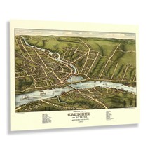
HISTORIX Vintage 1878 Gardiner & Pittston Maine Map Poster - 18x24 Inch Vintage
$39.99
View full item details »

Shipping options
Seller handling time is 2 business days Details
FREE via to United States
Return policy
Full refund available for DOAs
Details
Purchase protection
Payment options
PayPal accepted
PayPal Credit accepted
Venmo accepted
PayPal, MasterCard, Visa, Discover, and American Express accepted
Maestro accepted
Amazon Pay accepted
Nuvei accepted
View full item details »
Shipping options
Seller handling time is 2 business days Details
FREE via to United States
Return policy
Full refund available for DOAs
Details
Purchase protection
Payment options
PayPal accepted
PayPal Credit accepted
Venmo accepted
PayPal, MasterCard, Visa, Discover, and American Express accepted
Maestro accepted
Amazon Pay accepted
Nuvei accepted
Item traits
| Category: | |
|---|---|
| Quantity Available: |
8 in stock |
| Condition: |
New |
| UPC: |
705514894328 |
| MPN: |
ENMAP07071824 |
| EAN: |
0705514894328 |
| Color: |
Natural |
| binding: |
unbound |
| format: |
unbound |
| language: |
english |
| manufacturer: |
HISTORIX |
| Externally Assigned Product Identifier: |
0705514894328 |
| Item Shape: |
Rectangular |
| Bullet Point: | |
| Publication Date: |
1878T |
| Product Description: | |
| Brand: |
HISTORIX |
| Unspsc Code: |
55101500 |
| Map Scale: |
1000 |
| Item Name: | |
| Item Type Keyword: |
prints |
| Product Site Launch Date: |
2024-07-11T22:46:27.592Z |
| Part Number: |
ENMAP07071824 |
| Style: |
Classic |
Listing details
| Seller policies: | |
|---|---|
| Shipping discount: |
Seller pays shipping for this item. |
| Posted for sale: |
More than a week ago |
| Item number: |
1735174225 |
Item description
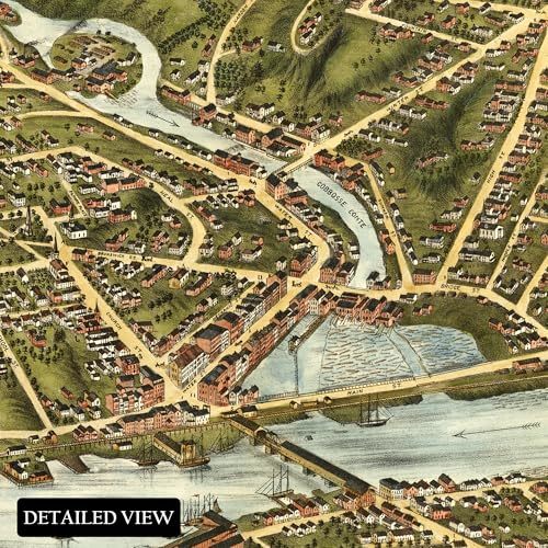
Located at the head of the navigable waters of the Kennebec River in southern Maine, Gardiner and Pittston stand as living testaments to history. Their classic architecture and distinct culture, which have been attracting tourists for centuries, are steeped in rich historical significance. The city was founded by the influential Boston physician Sylvester Gardiner in 1754. His vision and promotion led to the towns blooming to over one hundred thousand acres with a bustling local economy that attracted residents from Western Europe and other North American colonies in the years leading up to the American Revolution.
The towns' location at the confluence of the Cobbosseecontee and Kennebec Rivers was recognized by Gardiner as an ideal site for millworks, spurring the early growth of Pittston and Gardiner as the colonies continued to expand. Bird's-eye perspectives were created during the eighteenth and nineteenth centuries to promote towns and villages nationwide by featuring prominent local attractions, including civic buildings, religious institutions, educational opportunities, and other notable natural features, to entice residents from different regions. Panoramic maps were not used for navigation and often feature unique scales that give them their incredibly distinctive style, which immediately transports the viewer back in time, creating an indelible link between the past and present.
This bird's eye perspective captures Gardiner and Pittston in a period of significant transformation as the nation neared the turn of the century and a new era of modernity.
Additional Details
------------------------------
Bullet point: VINTAGE MAP REPRODUCTION: You?ll love this high quality historic reproduction of 1878 Gardiner Pittston Maine Map Poster. Our museum quality prints are archival grade, which means it will look great and last without fading for over 100 years. Our print to order maps are made in the USA and each map is inspected for quality. This beautiful artwork is a perfect addition to your themed decor. Vintage maps look great in the home, study or office. They make a perfect gift as well.
Product description:
Located at the head of the navigable waters of the Kennebec River in southern Maine, Gardiner and Pittston stand as living testaments to history. Their classic architecture and distinct culture, which have been attracting tourists for centuries, are steeped in rich historical significance. The city was founded by the influential Boston physician Sylvester Gardiner in 1754. His vision and promotion led to the towns blooming to over one hundred thousand acres with a bustling local economy that attracted residents from Western Europe and other North American colonies in the years leading up to the American Revolution.
The towns' location at the confluence of the Cobbosseecontee and Kennebec Rivers was recognized by Gardiner as an ideal site for millworks, spurring the early growth of Pittston and Gardiner as the colonies continued to expand. Bird's-eye perspectives were created during the eighteenth and nineteenth centuries to promote towns and villages nationwide by featuring prominent local attractions, including civic buildings, religious institutions, educational opportunities, and other notable natural features, to entice residents from different regions. Panoramic maps were not used for navigation and often feature unique scales that give them their incredibly distinctive style, which immediately transports the viewer back in time, creating an indelible link between the past and present.
This bird's eye perspective captures Gardiner and Pittston in a period of significant transformation as the nation neared the turn of the century and a new era of modernity.
Format: wall_map
Loading
This item has been added to your cart
 HISTORIX Vintage 1878 Gardiner & Pittston Maine Map Poster - 18x24 Inch Vintage added to cart.
8 available in stock
HISTORIX Vintage 1878 Gardiner & Pittston Maine Map Poster - 18x24 Inch Vintage added to cart.
8 available in stock
View Cart or continue shopping.
 Please wait while we finish adding this item to your cart.
Get an item reminder
We'll email you a link to your item now and follow up with a single reminder (if you'd like one). That's it! No spam, no hassle.
Already have an account?
Log in and add this item to your wish list.