Rendered at 10:28:50 08/13/25

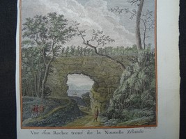


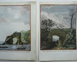
New Zealand, two views, Tolaga Bay, Thomas Cook, 1774, Vue d'un Rocher troue d
$119.00
Ships from
Spain

Shipping options
Estimated to arrive by Tue, Aug 19th.
Details
$15.00 via Standard shipping (1 to 5 business days) to United States
Ships from
Spain
Offer policy
OBO - Seller accepts offers on this item.
Details
Return policy
Full refund available within 30 days
Purchase protection
Payment options
PayPal accepted
PayPal Credit accepted
Venmo accepted
PayPal, MasterCard, Visa, Discover, and American Express accepted
Maestro accepted
Amazon Pay accepted
Nuvei accepted
Item traits
| Category: | |
|---|---|
| Quantity Available: |
Only one in stock, order soon |
| Condition: |
Unspecified by seller, may be new. |
| Type: |
Pictorial/Bird's Eye |
| Original/Reproduction: |
Antique Original |
| Year: |
1774 |
| Country/Region: |
New Zealand |
| Format: |
Atlas Map |
| Printing Technique: |
Copper Plate |
| Cartographer/Publisher: |
Thomas Cook |
Listing details
| Seller policies: | |
|---|---|
| Shipping discount: |
No combined shipping offered |
| Posted for sale: |
More than a week ago |
| Item number: |
1757185275 |
Item description
Genuine
old maps and engravings
New
Zealand, two views, Tolaga Bay,
Thomas
Cook, 1774, Vue d'un Rocher troue de la Nouvelle Zelande / Village
fortifie bati fur un Rocher troue de la Nouvelle Zelande
Cartographer / Cartografo
Thomas
Cook / Benard
Title / Título
Vue
d'un Rocher troue de la Nouvelle Zelande / Village fortifie bati
fur un Rocher troue de la Nouvelle Zelande
Year / Año
1774
Size / Tamaño
Images
20x18cm,
pages
25,5x19cm
Description / Descripcion
Two
views of the coast of New Zealand as seen from the ship of Thomas
Cook. From the first French edition of the Official Account of
Cook's voyage to Australia, Paris, 1774.
1.
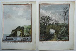
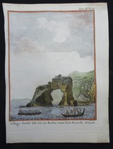
Vue d'un Rocher troue de la Nouvelle Zelande
Rare
engraving from the French edition of the accounts of Cook's first
voyage, published (1774) the year after the English edition
(1773). The title in the English versions was: [A view of a
perforated rock in Tolaga Bay in New Zealand]. View of Arched
Rock, Tolaga Bay, on New Zealand's north-east coast of the North
Island. Cook visited the area in 1769. Sporing, the artist, has
depicted the Endeavours' pinnance, which was moving about the bay
on the same day in the process of wooding and watering the ship.
The discovery of the view was recorded We saw an extraordinary
natural curiosity. In pursuing a valley bounded on each side by
steep hills we on a sudden saw a most noble arch or Cavern through
the face of a rock leading directly to the sea, so that through it
we had not only a view of the bay and hills on the other side but
an opportunity of imagining a ship or any other grand object
opposite it. It was certainly the most magnificent surprize. I
have ever met with so much is pure nature superior to art in these
cases' Banks, Jornal I, 419, 419, 24 October 1769.
Reference:
Beddie 660, p.124, Joppien 1.113B ill. pp. 173 (English edition)
2.
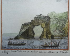
Village fortifie bati fur un Rocher troue de la Nouvelle Zelande
[English
title: A fortified town or village called a Hippah, built on a
perforated rock at Tolaga, New Zealand]. View of Arched Rock,
Tolaga Bay. 'After breakfast we all went ashore to see an Indian
Fort or Eppah.. We went to a bay where were two, we landed first
near a small one the most beautifuly romantick thing I ever saw.
It was built on a small rock detached from the main and surroundd
at high water, the top of this was fencd round with rails after
their manner but was not large enough to contain above 5 or 6
houses; the whole appeared totally inaccessible to any animal who
was not furnished with wings.' Banks, Journal I, 431-1, 12
November 1769. Reference: Joppien 1.122B ill. pp. 180
Both
views were engraved by Robert Benard for the 1774 French edition
of Hawkesworth's 1773 account of Cook's voyages. It follows the
1772-1773 English edition engraved by William Whitchurch and
published in 1773.
Condition / Estado
Very
good, some
small
repairs
margin, not
affecting the images.
Remarks / Comentarios
Please
read the part about the condition of the map and study the
pictures carefully before buying. I sell original maps, often
several centuries old, and they therefore will have signs of
age and use.
Por
favor, estudie atentamente las fotos y el texto para conocer el
estado del mapa antes de adquirirlo. Se trata de un mapa original
que tiene unos siglos de antigüedad, razon por la que presenta
ciertas marcas de uso.
Payment
and shipment / Pago y envío
Payment / Pago
With
bank transfer to bank account or with PayPal (the seller prefers a
bank transfer).
Pago
por transferencia bancaria o con PayPal (el vendedor prefiere
transferencia).
Shipment / Envío
In
case you choose to have the item shipped without certified/insured
mail, the seller will not be responsible for safe arrival of the
shipment. If
needed, a proof of shipment can be provided.
En
caso de que usted no elija correo certificado, el vendedor no se
hara responsable si su paquete no llega bien. Si
lo desea, recibira un comprobante de envío.
Return policy / devolucion
In
case you do not like the map, you can return it to the seller
within 10 days after receiving it. You are responsible for the
costs for return shipment/insurance. You will receive a full
refund of the purchase amount (excl. shipping costs) after the
seller has the map.
En
caso de que al final no le guste el mapa, puede devolverlo en un
plazo de 10 días tras recibirlo. Los gastos de envío
(certificado) corren de su cargo. Cuando el vendedor reciba el
mapa, le sera devuelto el importe completo de la compra
(excluidos los gastos de envío).
SHIPMENT
CAN BE COMBINED
PUEDEN
MANDARSE VARIOS MAPAS EN UN SOLO ENVÍO
24
31 AL
Added to your wish list!
- New Zealand, two views, Tolaga Bay, Thomas Cook, 1774, Vue d'un Rocher troue d
- 1 in stock
- Price negotiable
- Handling time 1 day. Estimated delivery: Tue, Aug 19th
- Returns/refunds accepted
Get an item reminder
We'll email you a link to your item now and follow up with a single reminder (if you'd like one). That's it! No spam, no hassle.
Already have an account?
Log in and add this item to your wish list.