HISTORIX Vintage 1888 Indiana State Map - and similar items


Free Shipping
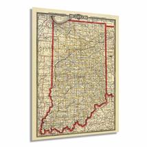
HISTORIX Vintage 1888 Indiana State Map - 18x24 Inch Vintage Map of Indiana Wall
$39.99 - $59.99
View full item details »

Shipping options
Seller handling time is 1 business day Details
FREE via to United States
Return policy
Full refund available for DOAs
Details
Purchase protection
Payment options
PayPal accepted
PayPal Credit accepted
Venmo accepted
PayPal, MasterCard, Visa, Discover, and American Express accepted
Maestro accepted
Amazon Pay accepted
Nuvei accepted
View full item details »
Shipping options
Seller handling time is 1 business day Details
FREE via to United States
Return policy
Full refund available for DOAs
Details
Purchase protection
Payment options
PayPal accepted
PayPal Credit accepted
Venmo accepted
PayPal, MasterCard, Visa, Discover, and American Express accepted
Maestro accepted
Amazon Pay accepted
Nuvei accepted
Item traits
| Category: | |
|---|---|
| Quantity Available: |
16 in stock |
| Condition: |
New |
| ASIN: |
B086GKQN6G |
| Item Name: |
HISTORIX 1888 Map of Indiana |
| manufacturer: |
Historix |
| Item Type Keyword: |
prints |
| Brand: |
HISTORIX |
| Unspsc Code: |
52140000 |
| sizes: |
Listing details
| Seller policies: | |
|---|---|
| Shipping discount: |
Seller pays shipping for this item. |
| Posted for sale: |
April 23 |
| Item number: |
1741849226 |
Item description
Initially published in 1888, this Railway map was produced by one of the most well-known 19th-century map makers George Cram. Crams company went on to become the first American company to release a World Atlas in 1901. This incredibly detailed illustration provided a wealth of information for merchants and residents alike and is a unique link to life as an American in the mid-1800s.
Before the Railway system was completed in 1865, the Mississippi River was the primary form of transit for exporting goods out of Indiana via the Wabash and Ohio River. The Railways became necessary for the northern regions of Indiana, especially in the 1880s, when a natural gas boom transformed the economy and spurred massive growth and population expansions. At the time, the Indiana Gas Field was the largest in the world. By allowing east-west transport, the Railways were Indianas connection to the rest of the nation, and the links permitted the state economy to thrive.
The rails carried a romance of the time, and in the mid-1850s, Indiana was rapidly building tracks with young men enamored with a life outside of the agrarian establishment. Indianapolis became known as The City of Railroads, with seven railroads converging in the city. Following the conclusion of the Civil War, the rail line became a useful tool for passengers as well as freight and interurban travel. This map was published the same year as the completion of the new Union Station in Indianapolis.
Our museum quality Indiana Map Art comes printed with archival ink on premium heavyweight matte paper. Shipped in a sturdy cardboard tube your Indiana Poster will arrive ready to be framed. This eye-catching print makes the perfect gift for anyone that loves history and imagery.
Loading
This item has been added to your cart
 HISTORIX Vintage 1888 Indiana State Map - 18x24 Inch Vintage Map of Indiana Wall added to cart.
16 available in stock
HISTORIX Vintage 1888 Indiana State Map - 18x24 Inch Vintage Map of Indiana Wall added to cart.
16 available in stock
View Cart or continue shopping.
 Please wait while we finish adding this item to your cart.
Get an item reminder
We'll email you a link to your item now and follow up with a single reminder (if you'd like one). That's it! No spam, no hassle.
Already have an account?
Log in and add this item to your wish list.