HISTORIX Vintage 1865 Puget Sound Map Poster and similar items


Free Shipping
HISTORIX Vintage 1865 Puget Sound Map Poster - 18x24 Inch Vintage Map of Puget S
$39.99 - $59.99
View full item details »

Shipping options
Seller handling time is 1 business day Details
FREE via to United States
Return policy
Full refund available for DOAs
Details
Purchase protection
Payment options
PayPal accepted
PayPal Credit accepted
Venmo accepted
PayPal, MasterCard, Visa, Discover, and American Express accepted
Maestro accepted
Amazon Pay accepted
Nuvei accepted
View full item details »
Shipping options
Seller handling time is 1 business day Details
FREE via to United States
Return policy
Full refund available for DOAs
Details
Purchase protection
Payment options
PayPal accepted
PayPal Credit accepted
Venmo accepted
PayPal, MasterCard, Visa, Discover, and American Express accepted
Maestro accepted
Amazon Pay accepted
Nuvei accepted
Item traits
| Category: | |
|---|---|
| Quantity Available: |
16 in stock |
| Condition: |
New |
| UPC: |
737214972778 |
| Item Name: |
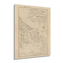
1865 Puget Sound Haro and Rosario Straits |
| Item Type Keyword: |
prints |
| Product Site Launch Date: |
2021-10-13T04:56:44.792Z |
| Unspsc Code: |
60121013 |
| sizes: |
Listing details
| Seller policies: | |
|---|---|
| Shipping discount: |
Seller pays shipping for this item. |
| Posted for sale: |
April 13 |
| Item number: |
1738906780 |
Item description
Published during a period of significant growth for the region, this depiction of Puget Sound and the Rosario Straits bears a unique aesthetic and distinctive style that immediately transports the viewer back in time. The mid-nineteenth century saw the region grow from a remote fur-trapping outpost to a thriving port with international importing and exporting driving a prosperous economy and attracting immigrants from America, Canada, Western Europe, and Asia. The completion of the Lake Superior and Puget Sound Rail lines in 1865 further increased access and expansion.
The Rosario Straits are a critical shipping lane discovered by Spanish sailors in 1790 and allowed access to the Northwest only sixteen years before the overland discovery by Lewis and Clark. President Thomas Jefferson commissioned the expedition following the completion of the Louisiana Purchase in 1803 to establish an American presence in the Northwest before European settlers could arrive.
Puget Sound extends more than one hundred miles from Deception Pass in the North to Olympia in the South. The inlet of the Pacific Ocean is part of the Salish Sea and refers to the body of water itself and the cities and towns located on its banks, including Seattle, Tacoma, and Everett. The Sound was discovered in 1792 by British Royal Navy Captain George Vancouver in an attempt to locate the fabled Northwest Passage. This is truly an authentic piece of cartographical and maritime history. As the region’s ports grew and railroads increased access, the region became one of the most iconic in the Northwest.
Our museum quality giclee print comes printed with archival ink on premium heavyweight matte paper. Shipped in a sturdy cardboard tube your print will arrive ready to be framed. This eye-catching vintage map reproduction print makes the perfect gift for anyone that loves history and imagery.
Loading
This item has been added to your cart
 HISTORIX Vintage 1865 Puget Sound Map Poster - 18x24 Inch Vintage Map of Puget S added to cart.
16 available in stock
HISTORIX Vintage 1865 Puget Sound Map Poster - 18x24 Inch Vintage Map of Puget S added to cart.
16 available in stock
View Cart or continue shopping.
 Please wait while we finish adding this item to your cart.
Get an item reminder
We'll email you a link to your item now and follow up with a single reminder (if you'd like one). That's it! No spam, no hassle.
Already have an account?
Log in and add this item to your wish list.