HISTORIX Vintage 1889 Puget Sound Art Canvas and similar items


Free Shipping
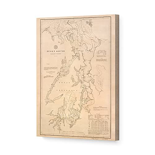
HISTORIX Vintage 1889 Puget Sound Art Canvas - 16x24x1.5 Inch Canvas Wrap Vintag
$251.99 - $280.99
View full item details »

Shipping options
Seller handling time is 1 business day Details
FREE via to United States
Return policy
Full refund available for DOAs
Details
Purchase protection
Payment options
PayPal accepted
PayPal Credit accepted
Venmo accepted
PayPal, MasterCard, Visa, Discover, and American Express accepted
Maestro accepted
Amazon Pay accepted
Nuvei accepted
View full item details »
Shipping options
Seller handling time is 1 business day Details
FREE via to United States
Return policy
Full refund available for DOAs
Details
Purchase protection
Payment options
PayPal accepted
PayPal Credit accepted
Venmo accepted
PayPal, MasterCard, Visa, Discover, and American Express accepted
Maestro accepted
Amazon Pay accepted
Nuvei accepted
Item traits
| Category: | |
|---|---|
| Quantity Available: |
16 in stock |
| Condition: |
New |
| ASIN: |
B094QTT97F |
| Item Name: |
1889 Puget Sound Map |
| Item Type Keyword: |
artwork |
| Product Site Launch Date: |
2021-05-12T08:42:50.402Z |
| Unspsc Code: |
60121013 |
| sizes: |
Listing details
| Seller policies: | |
|---|---|
| Shipping discount: |
Seller pays shipping for this item. |
| Posted for sale: |
April 13 |
| Item number: |
1738879109 |
Item description
Created in 1889 and depicting relief heights and nautical charts, this map of Puget Sound is a historical document of a region rich with history and culture. Named in 1792 after Huguenot Lieutenant Peter Puget, the Puget Sound refers to both the waters and surrounding land. This map followed the completion of the Northern Pacific railroad line in 1888 which connected the entire region to the eastern United States. Active trading and the rich waters provided ample opportunity for commercial fishing, and these made up the primary economic drivers. The diverse flora and fauna of the area have drawn recreational fisherman here for decades as well in hunt of steelhead trout and sockeye salmon.
Digitally restored and enhanced to correct colors, alignment and with minor blemishes removed, this unique piece of nautical history is sure to interest any lover of American or nautical history. The map also details the many lighthouses of the region as well as the safe channels for vessels to navigate, tides and buoy locations. This is an uncommon piece of cartographical history and would make the perfect gift for anyone that appreciates the rich history of the region, or maritime antiquities.
This striking reproduction is printed on heavy matte stock with museum quality archival ink, your print will come shipped in a sturdy cardboard tube to ensure 100% satisfaction. Our reproductions make an ideal piece of decor for any study, classroom, office or home.
Our ready-to-hang canvas wall art prints are made in the USA using the highest quality materials with professional craftsmanship. This beautiful artwork is a perfect addition to your themed decor. Historic prints look great in the home, study or office. They also make an unforgettable gift.
Loading
This item has been added to your cart
 HISTORIX Vintage 1889 Puget Sound Art Canvas - 16x24x1.5 Inch Canvas Wrap Vintag added to cart.
16 available in stock
HISTORIX Vintage 1889 Puget Sound Art Canvas - 16x24x1.5 Inch Canvas Wrap Vintag added to cart.
16 available in stock
View Cart or continue shopping.
 Please wait while we finish adding this item to your cart.
Get an item reminder
We'll email you a link to your item now and follow up with a single reminder (if you'd like one). That's it! No spam, no hassle.
Already have an account?
Log in and add this item to your wish list.