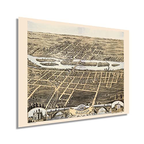
1869 Batavia Illinois Map - Old Batavia City and 50 similar items


Free Shipping
1869 Batavia Illinois Map - Old Batavia City Kane County State of IL Map History
$59.99 - $82.99
View full item details »

Shipping options
Seller handling time is 1 business day Details
FREE in United States
Return policy
Full refund available for DOAs
Details
Purchase protection
Payment options
PayPal accepted
PayPal Credit accepted
Venmo accepted
PayPal, MasterCard, Visa, Discover, and American Express accepted
Maestro accepted
Amazon Pay accepted
Nuvei accepted
View full item details »
Shipping options
Seller handling time is 1 business day Details
FREE in United States
Return policy
Full refund available for DOAs
Details
Purchase protection
Payment options
PayPal accepted
PayPal Credit accepted
Venmo accepted
PayPal, MasterCard, Visa, Discover, and American Express accepted
Maestro accepted
Amazon Pay accepted
Nuvei accepted
Item traits
| Category: | |
|---|---|
| Quantity Available: |
16 in stock |
| Condition: |
New |
| Subject: |
Maps |
| Style: |
Vintage |
| Type: |
Wall Art |
| Features: |
Museum Quality |
| Theme: |
Vintage |
| Artist: |
Various |
| Region of Origin: |
Made in the USA |
| Brand: |
HISTORIX |
| Sizes: |
Listing details
| Seller policies: | |
|---|---|
| Shipping discount: |
Seller pays shipping for this item. |
| Posted for sale: |
April 13 |
| Item number: |
1738798425 |
Item description
Feature Points
VINTAGE MAP REPRODUCTION: You?ll love this high quality historic reproduction of 1869 Batavia Illinois Map Poster. Our museum quality prints are archival grade, which means it will look great and last without fading for over 100 years. Our print to order maps are made in the USA and each map is inspected for quality. This beautiful artwork is a perfect addition to your themed decor. Vintage maps look great in the home, study or office. They make a perfect gift as well.
MUSEUM QUALITY: This high quality map print will be a great addition to your vintage-themed wall. Don't waste money on cheap-looking, thin paper posters. We use thick, fine art print quality matte paper. Our professional?s choice matte paper displays artwork in high detail without glare. The color is vibrant and text is easy to read. When framed, this map looks absolutely stunning.
A LOOK BACK AT HISTORY: This is an impressive, historic reproduction of 1869 Batavia Map of Illinois Poster. A true piece of history. See our product description section for more fascinating information about this historic map and its significance.
READY TO FRAME: This print includes a 0.2 inch border for a perfect frame fit and look. Our maps are designed to fit easy-to-find standard frame sizes, saving you money from having to pay for a custom frame. Each map is inspected for quality and shipped in a rigid tube.
HISTORIX: We love history and art. Sometimes old maps have tears, folds, separations and other blemishes. We digitally restore and enhance maps while keeping its historical character. All our maps are proudly made in the USA. Customers all over the world love our vintage maps and we know you will too.
Additional Information
Batavia is the oldest city in Kane County, one of the collar counties of Chicago, and is part of the Tri-City area. First settled in 1833, Batavia would not be officially incorporated until 1872 and was experiencing a period of significant growth at the time of this publication. As a suburb of Chicago, Batavia enjoyed a period of tremendous prosperity during the mid-nineteenth century as economic expansion spurred population growth across the North, particularly in major cities like Chicago. Its location on the Fox River allowed numerous windmills to be installed and led to the town becoming known as the Windmill City in the late nineteenth century.
Produced and published by Albert Ruger, this birds eye perspective bears a remarkable style and distinctive aesthetic. Ruger was an early pioneer of the form in the United States and would go on to produce panoramic maps of cities and towns across America. Ruger?s maps bear characteristic flourishes and served as marketing materials to attract residents and merchants alike, featuring prominent civic buildings and economic opportunities. Birds eye perspectives were widely popular during the mid-nineteenth and early twentieth centuries, and they are immediately recognizable and transport the viewer back in time, creating an indelible bond between the past and present.
This is an authentic piece of American cartographical history that captures a distinct moment in Batavia?s rich history as the nation rebuilt in the years following the conclusion of the American Civil War and approached the turn of the twentieth century.
Our museum quality giclee print comes printed with archival ink on premium heavyweight matte paper. Shipped in a sturdy cardboard tube your print will arrive ready to be framed. This eye-catching vintage map reproduction print makes the perfect gift for anyone that loves history and imagery.


 - $15.00")


-
Refine your browsing experience
We can show you more items that are exactly like the original item, or we can show you items that are similar in spirit. By default we show you a mix.


 *Francine De... - $75.00")


 Edition Lithograph on Paper- Las... - $1,695.00")
This item has been added to your cart
 1869 Batavia Illinois Map - Old Batavia City Kane County State of IL Map History added to cart.
16 available in stock
1869 Batavia Illinois Map - Old Batavia City Kane County State of IL Map History added to cart.
16 available in stock
View Cart or continue shopping.
 Please wait while we finish adding this item to your cart.
Get an item reminder
We'll email you a link to your item now and follow up with a single reminder (if you'd like one). That's it! No spam, no hassle.
Already have an account?
Log in and add this item to your wish list.